THIS AVALANCHE FORECAST EXPIRED ON February 5, 2018 @ 6:58 am
Avalanche Forecast published on February 4, 2018 @ 6:58 am
Issued by Andy Anderson - Tahoe National Forest - Sierra Avalanche Center

The avalanche danger will remain LOW today. Some small loose wet avalanche problems may still form on some isolated terrain features as the day warms up. Slab avalanches remain unlikely.

1. Low

?

Above Treeline
Generally safe avalanche conditions. Watch for unstable snow on isolated terrain features.

1. Low

?

Near Treeline
Generally safe avalanche conditions. Watch for unstable snow on isolated terrain features.

1. Low

?

Below Treeline
Generally safe avalanche conditions. Watch for unstable snow on isolated terrain features.
    Generally safe avalanche conditions. Watch for unstable snow on isolated terrain features.
Avalanche Problem 1: Loose Wet
  • Type ?
  • Aspect/Elevation ?
  • Likelihood ?
    Certain
    Very Likely
    Likely
    Possible
    Unlikely
  • Size ?
    Historic
    Very Large
    Large
    Small

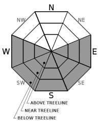
Today's warming should melt through last night's refreeze allowing wet snow to form on sun-exposed E-SE-S-SW-W aspects. In most places, this wet snow should not get very deep due to a combination of limited snow cover on S-SW-W aspects, well-established drainage channels in the existing snowpack, and the potential for some afternoon clouds. Some small loose wet snow instabilities like roller balls, pinwheels, or loose wet avalanches that do not entrain enough snow to bury a person (D1 in size) may form on isolated terrain features. Steep E-SE aspects where more snow exists and/or where the recent snow has not fully transitioned to melt-freeze snow represent the best places to trigger a small, isolated loose wet avalanche.

recent observations

* Spring-like corn snow formed on SE-S-SW aspects where snow cover existed on Red Lake Peak and in the Bear Valley backcountry above 8400 ft. yesterday. Ski cuts on E aspects on Red Lake Peak triggered small roller balls around midday.

* Little to no snow cover exists on the sun-exposed SE-S-SW aspects below 8400 ft. in the Bear Valley backcountry. 

* Large cornice collapses had occurred in the last week along exposed ridgelines above Underwood Bowl (Bear Valley backcountry).

* Snowpit data and observations on northerly aspects above 8100 ft. in the Bear Valley backcountry showed a well-consolidated snowpack with cold unconsolidated surface snow on some open true N facing slopes and wet sticky snow/breakable crusts on tree covered slopes or on more sun-exposed NW and ENE aspects

Weather and CURRENT CONDITIONS
weather summary

Temperatures at the upper elevations remained in the mid to upper 30's overnight. In the valleys, some areas dipped below freezing due to cold air pooling at the lower elevations. These inversion conditions should lift and give way to another warm spring-like day. The winds and cloud cover may start to increase this afternoon and tomorrow due to a weak system passing near the region. The strong high-pressure ridge parked over the area will keep the weather warm and dry for the foreseeable future.

CONDITIONS ALONG THE SIERRA CREST BETWEEN 8200 FT. AND 9200 FT. IN THE LAST 24 HOURS
6am temperature: 33 to 39 deg. F.
Max. temperature: 46 to 54 deg. F.
Average ridgetop wind direction: E to NE
Average ridgetop wind speed: 20 to 25 mph
Maximum ridgetop wind gust: 48 mph
New snowfall: 0 inches
Total snow depth: 28 to 50 inches
Two-Day Mountain Weather Forecast Produced in partnership with the Reno NWS
For 7000 ft. to 8000 ft.
Sunday Sunday Night Monday
Weather: Sunny becoming partly cloudy in the afternoon Partly cloudy Partly cloudy
Temperatures: 50 to 56 deg. F. 31 to 37 deg. F. 53 to 58 deg. F.
Mid Slope Winds: Variable Variable Variable
Wind Speed: Light Light Light
Expected snowfall: 0 0 0
For 8000 ft. to 9000 ft.
Sunday Sunday Night Monday
Weather: Sunny becoming partly cloudy this afternoon Partly cloudy Partly cloudy
Temperatures: 47 to 52 deg. F. 32 to 37 deg. F. 49 to 54 deg. F.
Ridge Top Winds: Northwest Northwest West
Wind Speed: 10 mph 10 to 15 mph with gusts to 35 mph after midnight 15 to 25 mph with gusts to 40 mph
Expected snowfall: 0 0 0
Disclaimer

This avalanche advisory is provided through a partnership between the Tahoe National Forest and the Sierra Avalanche Center. This advisory covers the Central Sierra Nevada Mountains between Yuba Pass on the north and Ebbetts Pass on the south. Click here for a map of the forecast area. This advisory applies only to backcountry areas outside established ski area boundaries. This advisory describes general avalanche conditions and local variations always occur. This advisory expires 24 hours after the posted time unless otherwise noted. The information in this advisory is provided by the USDA Forest Service who is solely responsible for its content.

For a recorded version of the Avalanche Advisory call (530) 587-3558 x258