THIS AVALANCHE FORECAST EXPIRED ON February 6, 2018 @ 6:58 am
Avalanche Forecast published on February 5, 2018 @ 6:58 am
Issued by Andy Anderson - Tahoe National Forest - Sierra Avalanche Center

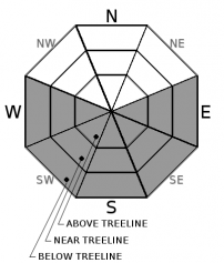
LOW avalanche danger will exist at all elevations today. Daytime warming may allow some small loose wet avalanche problems to form on some isolated sun-exposed terrain features where snow coverage exists.

1. Low

?

Above Treeline
Generally safe avalanche conditions. Watch for unstable snow on isolated terrain features.

1. Low

?

Near Treeline
Generally safe avalanche conditions. Watch for unstable snow on isolated terrain features.

1. Low

?

Below Treeline
Generally safe avalanche conditions. Watch for unstable snow on isolated terrain features.
    Generally safe avalanche conditions. Watch for unstable snow on isolated terrain features.
Avalanche Problem 1: Loose Wet
  • Type ?
  • Aspect/Elevation ?
  • Likelihood ?
    Certain
    Very Likely
    Likely
    Possible
    Unlikely
  • Size ?
    Historic
    Very Large
    Large
    Small

Some thin high clouds and increased winds may slow down today's melting, but warm temperatures and sunshine should still allow wet snow to form on sun-exposed E-SE-S-SW-W aspects. Since limited snow cover exists on the SE-S-SW-W aspects and the snowpack has already been through several melt-freeze cycles, this wet snow should remain shallow keeping wet snow instabilities small and isolated as well. Small roller balls, pinwheels, or loose wet avalanches that do not entrain enough snow to bury a person (D1 in size) may form on some isolated terrain features. Steep E-SE aspects where more snow exists and/or where the recent snow has not fully transitioned to melt-freeze snow represent the best places to trigger a small, isolated loose wet avalanche.

recent observations

* Spring-like corn snow formed on SE-S-SW aspects where snow cover existed in the Bear Valley backcountry yesterday by 10 am. Ski cuts on S facing test slopes on Incline Lake Peak triggered small roller balls and pinwheels at that time as well.

* Little to no snow cover existed on the sun-exposed SE-S-SW aspects below 8500 ft. in the Bear Valley backcountry and on Incline Lake Peak.  

* Snowpit data and observations on northerly aspects in the Bear Valley backcountry and on Incline Lake Peak showed a well-consolidated snowpack with cold unconsolidated surface snow on some open true N facing slopes. Wet sticky snow/breakable crusts existed on tree covered slopes or on more sun-exposed NW and ENE aspects in the Bear Valley backcountry. Below 7800 ft. coverage on north aspects decreased in the Bear Valley backcountry.

Weather and CURRENT CONDITIONS
weather summary

Inversion conditions exist again this morning with colder temperatures in the valleys than at the upper elevations. The inversion should lift as the day warms up. The forecast calls for some thin cloud cover and increased winds today due to a small system passing by north of the area. Dry weather with April-like temperatures should continue as long as the high-pressure ridge remains parked over the west coast. 

CONDITIONS ALONG THE SIERRA CREST BETWEEN 8200 FT. AND 9200 FT. IN THE LAST 24 HOURS
6am temperature: 35 to 42 deg. F.
Max. temperature: 51 to 55 deg. F.
Average ridgetop wind direction: West and northeast
Average ridgetop wind speed: 10 to 15 mph
Maximum ridgetop wind gust: 42 mph
New snowfall: 0 inches
Total snow depth: 27 to 50 inches
Two-Day Mountain Weather Forecast Produced in partnership with the Reno NWS
For 7000 ft. to 8000 ft.
Monday Monday Night Tuesday
Weather: Partly cloudy to mostly sunny Clear Sunny
Temperatures: 53 to 58 deg. F. 28 to 34 deg. F. 48 to 53 deg. F.
Mid Slope Winds: Northwest Northwest Variable
Wind Speed: Light increasing to 10 to 15 mph with gusts to 25 mph in the afternoon 10 to 15 mph Light
Expected snowfall: 0 0 0
For 8000 ft. to 9000 ft.
Monday Monday Night Tuesday
Weather: Partly cloudy to mostly sunny Clear Sunny
Temperatures: 49 to 54 deg. F. 28 to 33 deg. F. 45 to 50 deg. F.
Ridge Top Winds: West North Northeast
Wind Speed: 15 to 20 mph with gusts to 40 mph 15 to 25 mph with gusts to 40 mph 15 to 25 mph with gusts to 35 mph
Expected snowfall: 0 0 0
Disclaimer

This avalanche advisory is provided through a partnership between the Tahoe National Forest and the Sierra Avalanche Center. This advisory covers the Central Sierra Nevada Mountains between Yuba Pass on the north and Ebbetts Pass on the south. Click here for a map of the forecast area. This advisory applies only to backcountry areas outside established ski area boundaries. This advisory describes general avalanche conditions and local variations always occur. This advisory expires 24 hours after the posted time unless otherwise noted. The information in this advisory is provided by the USDA Forest Service who is solely responsible for its content.

For a recorded version of the Avalanche Advisory call (530) 587-3558 x258