THIS AVALANCHE FORECAST EXPIRED ON January 15, 2018 @ 6:55 am
Avalanche Forecast published on January 14, 2018 @ 6:55 am
Issued by Andy Anderson - Tahoe National Forest - Sierra Avalanche Center

Triggering an avalanche has become unlikely on a regional scale; however, some unstable snow may still exist in isolated areas due to lingering persistent slab issues.  Avalanche danger is LOW for all elevations. Investigate the snowpack and determine if the area you want to travel in is one of those isolated places where the persistent slab problem may still linger. If so or if you don't have enough data for a clear answer, chose a different area. 

1. Low

?

Above Treeline
Generally safe avalanche conditions. Watch for unstable snow on isolated terrain features.

1. Low

?

Near Treeline
Generally safe avalanche conditions. Watch for unstable snow on isolated terrain features.

1. Low

?

Below Treeline
Generally safe avalanche conditions. Watch for unstable snow on isolated terrain features.
    Generally safe avalanche conditions. Watch for unstable snow on isolated terrain features.
Avalanche Problem 1: Persistent Slab
  • Type ?
  • Aspect/Elevation ?
  • Likelihood ?
    Certain
    Very Likely
    Likely
    Possible
    Unlikely
  • Size ?
    Historic
    Very Large
    Large
    Small

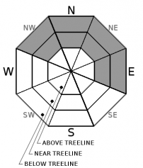
Triggering a persistent slab avalanche has become unlikely in most areas. While this weak layer may still exist on some NW-N-NE aspects and maybe some E aspects in near and below treeline terrain, observations indicate that it seems to be gaining strength. In areas where it was wet it is slowly refreezing and in other areas where it remained dry, it is slowly adjusting to the current load above it. Just because persistent slabs have become unlikely in most areas does not mean that triggering a persistent slab avalanche is impossible. Unstable persistent slabs that the additional weight of a person could trigger could still exist on some isolated terrain features. Open slopes sheltered from this winter's NE winds represent the best places to find lingering instability. More complex terrain like sheltered, shady couloirs, steep rocky slopes, or slopes with steep convex roll-overs where the persistent weak layer remains weak could also be suspect. 

Tools like quick snowpit tests, handpits, and probing can help identify those isolated areas where the persistent weak layer may still exist. Avoiding those isolated areas where instability may linger and slopes connected to those areas still remains a prudent choice. If one of these isolated areas were to release, it could release above the person who triggers it and it may not release until that trigger fully commits to the slope. This weak layer is more likely to exist in the mid to lower part of a slope and so evaluating the slope from the traditional start zone at the top of a slope may not provide a meaningful or accurate assessment. 

recent observations

* Snowpit tests from the Elephants Back area yesterday revealed unstable results on 2 isolated true north aspects where the old facet layer still remained weak. Data and observations from other aspects and a variety of elevations did not reveal any other signs of instability. Other isolated unstable test results have occurred near Slab Cliffs (Mount Rose area) and on Castle Peak (Donner Summit area) earlier this week. 

* Observations earlier this week targeting the persistent weak layer of loose weak snow on Red Lake Peak (Carson Pass area) and on Rubicon Peak and Peak 9,269' (West Shore Tahoe area) indicated that this layer and the overall snowpack continue to gain strength.

* NW-N-NE aspects above 8,000' in the Mt. Rose area and along the Sierra Crest north of Emerald Bay hold the best coverage at 2 to 4+ feet. Overall less snow cover exists south of Emerald Bay. Areas of decent coverage exist above 8,300' on NW-N-NE aspects in the Carson Pass area.  Coverage decreases dramatically on all other aspects.

Weather and CURRENT CONDITIONS
weather summary

Calm weather has allowed cold air to pool in the valleys overnight while the upper elevations remain warmer. A high-pressure ridge over the region should keep the weather dry and warm through Monday. The forecast calls for daytime highs in the upper 40's and low 50's above 7000 ft. Winds should start increasing tomorrow ahead of a storm system that is expected to move into the area Monday night and Tuesday. Check in with the Reno NWS for more details.

CONDITIONS ALONG THE SIERRA CREST BETWEEN 8200 FT. AND 9200 FT. IN THE LAST 24 HOURS
6am temperature: 36 to 41 deg. F.
Max. temperature: 45 to 47 deg. F.
Average ridgetop wind direction: East to south
Average ridgetop wind speed: 10 to 15 mph
Maximum ridgetop wind gust: 36 mph
New snowfall: 0 inches
Total snow depth: 21 to 38 inches
Two-Day Mountain Weather Forecast Produced in partnership with the Reno NWS
For 7000 ft. to 8000 ft.
Sunday Sunday Night Monday
Weather: Partly cloudy Mostly cloudy Mostly cloudy
Temperatures: 50 to 55 deg. F. 32 to 37 deg. F. 47 to 52 deg. F.
Mid Slope Winds: Variable Variable South
Wind Speed: Light Light with gusts to 25 mph after midnight Light in the morning increasing to 10 to 15 mph with gusts to 40 mph in the afternoon
Expected snowfall: 0 0 0
For 8000 ft. to 9000 ft.
Sunday Sunday Night Monday
Weather: Partly cloudy Mostly cloudy Mostly cloudy
Temperatures: 47 to 52 deg. F. 33 to 38 deg. F. 44 to 49 deg. F.
Ridge Top Winds: Variable Southwest South
Wind Speed: Light 15 to 20 mph with gusts to 25 mph increasing to 45 mph after midnight 20 to 30 mph with gusts to 60 mph
Expected snowfall: 0 0 0
Disclaimer

This avalanche advisory is provided through a partnership between the Tahoe National Forest and the Sierra Avalanche Center. This advisory covers the Central Sierra Nevada Mountains between Yuba Pass on the north and Ebbetts Pass on the south. Click here for a map of the forecast area. This advisory applies only to backcountry areas outside established ski area boundaries. This advisory describes general avalanche conditions and local variations always occur. This advisory expires 24 hours after the posted time unless otherwise noted. The information in this advisory is provided by the USDA Forest Service who is solely responsible for its content.

For a recorded version of the Avalanche Advisory call (530) 587-3558 x258