THIS AVALANCHE FORECAST EXPIRED ON January 17, 2018 @ 6:58 am
Avalanche Forecast published on January 16, 2018 @ 6:58 am
Issued by Andy Anderson - Tahoe National Forest - Sierra Avalanche Center

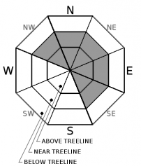
While the avalanche danger should remain LOW today due to the minimal snow accumulation expected, unstable snow may still exist in isolated areas due to lingering persistent slabs or very small pockets of newly formed wind slabs. If observations indicate that an isolated area of unstable snow may exist, choose different terrain. If more snow falls than forecasted, larger avalanche problems could exist and the avalanche danger could increase to MODERATE.

1. Low

?

Above Treeline
Generally safe avalanche conditions. Watch for unstable snow on isolated terrain features.

1. Low

?

Near Treeline
Generally safe avalanche conditions. Watch for unstable snow on isolated terrain features.

1. Low

?

Below Treeline
Generally safe avalanche conditions. Watch for unstable snow on isolated terrain features.
    Generally safe avalanche conditions. Watch for unstable snow on isolated terrain features.
Avalanche Problem 1: Persistent Slab
  • Type ?
  • Aspect/Elevation ?
  • Likelihood ?
    Certain
    Very Likely
    Likely
    Possible
    Unlikely
  • Size ?
    Historic
    Very Large
    Large
    Small

The 1 to 2 inches of snow expected today should not provide enough additional weight to make persistent slabs a more widespread problem. In most areas triggering a persistent slab avalanche will remain unlikely because the persistent weak layer has either become wet and mostly refrozen or it has become denser and adjusted to the weight of the current snowpack above it. However, this layer still lingers on some NW-N-NE aspects and triggering a persistent slab avalanche is not impossible on some isolated terrain features. Open slopes sheltered from this winter's NE winds at elevations above 8000 ft. represent the best places to find lingering instability. More complex terrain like sheltered, shady couloirs, steep rocky slopes, or slopes with steep convex roll-overs where the persistent weak layer remains weak could also be suspect. If more snow falls than forecasted, persistent slabs could become more widespread and easier to trigger

Tools like quick snowpit tests, handpits, and probing can help identify those isolated areas where the persistent weak layer may still exist. Avoiding those isolated areas where instability may linger and slopes connected to those areas still remains a prudent choice. If one of these isolated areas were to release, it could release above the person who triggers it and it may not release until that trigger fully commits to the slope. This weak layer is more likely to exist in the mid to lower part of a slope and so evaluating the slope from the traditional start zone at the top of a slope may not provide a meaningful or accurate assessment. 

Avalanche Problem 2: Wind Slab
  • Type ?
  • Aspect/Elevation ?
  • Likelihood ?
    Certain
    Very Likely
    Likely
    Possible
    Unlikely
  • Size ?
    Historic
    Very Large
    Large
    Small

While consequential wind slabs will remain unlikely today in most areas due to the paltry amounts of new snow expected from this storm, some small isolated wind slabs may start to form in the most wind-loaded areas. Wind-loading can magnify snow accumulation amounts significantly. These wind slabs should remain shallow and not extend very far away from ridgelines. It is unlikely that they would become large enough to bury a person or even pose much of a threat to backcountry travelers in most areas. However, in some isolated areas, they may be able to knock a person off balance. If more snow falls than forecasted, wind slabs could become larger, more widespread, and more consequential.

recent observations

* Snowpit tests from Castle Peak yesterday yielded slightly harder (more difficult to trigger) results in an area where tests from Friday yielded consistent unstable results. Recently other data and observations from Tamarack Peak (Mt. Rose backcountry), Elephants Back area (Carson Pass area), Castle Peak (Donner Summit area), and Slab Cliffs (Mount Rose area) indicated persistent slab instability may still linger in some isolated areas. 

* Observations earlier this week targeting the persistent weak layer of loose weak snow on Red Lake Peak (Carson Pass area) and on Rubicon Peak and Peak 9,269' (West Shore Tahoe area) indicated that this layer and the overall snowpack continue to gain strength.

* No human triggered persistent slab avalanches have been reported. 

* NW-N-NE aspects above 8,000' in the Mt. Rose area and along the Sierra Crest north of Emerald Bay hold the best coverage at 2 to 4+ feet. Overall less snow cover exists south of Emerald Bay. Areas of decent coverage exist above 8,300' on NW-N-NE aspects in the Carson Pass area.  Coverage decreases dramatically on all other aspects.

Weather and CURRENT CONDITIONS
weather summary

Some light precipitation started to fall across the region early this morning with snow levels in the 7500 to 8000 ft. range. So far only a trace to 1 inch of snow has accumulated above 7500 with light rain below 7500 ft. Southwest winds picked up overnight last night and should continue through the day. This small teaser storm should end today with only up to 2 more inches of snow accumulating above 7500 ft. The forecast does mention an unlikely but possible scenario with 2 to 5 inches of snow accumulation today. The forecast calls for one more warm dry day tomorrow before a strong winter storm arrives over the region on Thursday. Check in with the Reno NWS for more details. 

CONDITIONS ALONG THE SIERRA CREST BETWEEN 8200 FT. AND 9200 FT. IN THE LAST 24 HOURS
6am temperature: 32 to 37 deg. F.
Max. temperature: 47 to 49 deg. F.
Average ridgetop wind direction: Southwest
Average ridgetop wind speed: 20 to 30 mph
Maximum ridgetop wind gust: 64 mph
New snowfall: Trace to 1 inches
Total snow depth: 21 to 38 inches
Two-Day Mountain Weather Forecast Produced in partnership with the Reno NWS
For 7000 ft. to 8000 ft.
Tuesday Tuesday Night Wednesday
Weather: Mostly cloudy with scattered showers that are a mix of rain and snow throughout the day. Snow level 7500 ft. Mostly cloudy Mostly cloudy
Temperatures: 40 to 45 deg. F. 30 to 35 deg. F. 46 to 51 deg. F.
Mid Slope Winds: Southwest Southwest Southwest
Wind Speed: 10 to 15 mph with gusts to 45 mph decreasing to 30 mph in the afternoon Light increasing to 10 to 15 mph with gusts to 30 mph after midnight 10 to 15 mph with gusts to 30 mph
Expected snowfall: Rain: up to .1 in. | Snow up to 2 0 0
For 8000 ft. to 9000 ft.
Tuesday Tuesday Night Wednesday
Weather: Mostly cloudy with scattered snow showers throughout the day. Snow level 7500 ft. Mostly cloudy Mostly cloudy
Temperatures: 37 to 43 deg. F. 29 to 34 deg. F. 43 to 48 deg. F.
Ridge Top Winds: Southwest Southwest Southwest
Wind Speed: 20 to 35 mph with gusts to 70 mph decreasing to 50 mph in the afternoon 15 to 25 mph with gusts to 35 mph increasing to 50 mph after midnight 15 to 25 mph with gusts to 45 mph
Expected snowfall: up to 2 0 0
Disclaimer

This avalanche advisory is provided through a partnership between the Tahoe National Forest and the Sierra Avalanche Center. This advisory covers the Central Sierra Nevada Mountains between Yuba Pass on the north and Ebbetts Pass on the south. Click here for a map of the forecast area. This advisory applies only to backcountry areas outside established ski area boundaries. This advisory describes general avalanche conditions and local variations always occur. This advisory expires 24 hours after the posted time unless otherwise noted. The information in this advisory is provided by the USDA Forest Service who is solely responsible for its content.

For a recorded version of the Avalanche Advisory call (530) 587-3558 x258