THIS AVALANCHE FORECAST EXPIRED ON January 22, 2018 @ 7:00 am
Avalanche Forecast published on January 21, 2018 @ 7:00 am
Issued by Andy Anderson - Tahoe National Forest - Sierra Avalanche Center

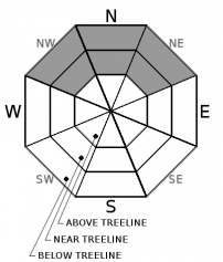
Lingering isolated areas of persistent slab avalanche problems will keep the avalanche danger at MODERATE in near and below treeline terrain. If an isolated human triggered persistent slab avalanche does occur, it could be large with significant consequences. Above treeline, avalanche danger is LOW.

1. Low

?

Above Treeline
Generally safe avalanche conditions. Watch for unstable snow on isolated terrain features.

2. Moderate

?

Near Treeline
Heightened avalanche conditions on specific terrain features. Evaluate snow and terrain carefully; identify features of concern.

2. Moderate

?

Below Treeline
Heightened avalanche conditions on specific terrain features. Evaluate snow and terrain carefully; identify features of concern.
    Heightened avalanche conditions on specific terrain features. Evaluate snow and terrain carefully; identify features of concern.
Avalanche Problem 1: Persistent Slab
  • Type ?
  • Aspect/Elevation ?
  • Likelihood ?
    Certain
    Very Likely
    Likely
    Possible
    Unlikely
  • Size ?
    Historic
    Very Large
    Large
    Small

Evidence of a lingering persistent slab problem continues in the form of some unstable snowpit tests on isolated near and below treeline NW-N-NE aspects. Observations and data indicate that breaking the persistent weak layer and triggering a persistent slab would be difficult to do, but that if it does break, the resulting avalanche could be large (up to D2 or D3) and destructive. Significant uncertainty and variability exist concerning where the persistent slab problem may or may not linger. Data and observations have not provided a clear explanation for the variations in stability between similar terrain at different locations.

Due to the uncertainty, variability, and potential high consequences of this difficult to trigger (low probability) avalanche problem, avoiding terrain where persistent slabs may exist represents a prudent choice. Near and below treeline NW-N-NE aspects sheltered from the NE winds hold the best potential for a lingering persistent slab problem. Collapsing and whumpfing, unstable snowpit test results, and handpits/probing into the snowpack to feel for a loose layer of weak snow under frim slab layers can help identify where persistent slab problems may still exist. Keep in mind that snowpits dug high on the slope may miss evidence of this problem since it is more likely in the mid to lower portions of the slope.


recent observations

* Some snowpit tests on near and below treeline N-NE aspects on Elephant's Hump (Carson Pass) yesterday and Upper Blue Lake and Twin Lake areas (South of Carson Pass) and Cold Stream Drainage (Donner Summit area) on Friday indicated that despite being difficult to trigger, some lingering persistent slab instability may remain.

* Observations from Andesite Peak (Donner Summit) and National Geographic Bowl (Granite Chief Wilderness) did not reveal any signs of instability associated with the persistent weak layer and snowpit tests indicated a well-consolidated snowpack.

* Small minor cracking occurred on a wind-loaded test slope on Granite Chief, but no larger wind slab instabilities were noted. 

* Skiers triggered some small loose dry sluffs on steep slopes in National Geographic Bowl.

Weather and CURRENT CONDITIONS
weather summary

Clouds and southwest winds should start to increase today ahead of a weak disturbance approaching the region. This small storm should arrive tonight and bring with it some light snow showers that last through tomorrow. The forecast only calls for up to 2 inches of new snow by the end of the day tomorrow. Winds should start to decrease tomorrow afternoon as the disturbance exists the area. 

CONDITIONS ALONG THE SIERRA CREST BETWEEN 8200 FT. AND 9200 FT. IN THE LAST 24 HOURS
6am temperature: 11 to 20 deg. F.
Max. temperature: 23 to 29 deg. F.
Average ridgetop wind direction: N and NW
Average ridgetop wind speed: 5 to 10 mph
Maximum ridgetop wind gust: 28 mph
New snowfall: 0 inches
Total snow depth: 25 to 47 inches
Two-Day Mountain Weather Forecast Produced in partnership with the Reno NWS
For 7000 ft. to 8000 ft.
Sunday Sunday Night Monday
Weather: Mostly cloudy with a slight chance of snow showers in the afternoon Cloudy with a chance of snow showers Mostly cloudy with a chance of snow showers throughout the day
Temperatures: 30 to 35 deg. F. 22 to 27 deg. F. 34 to 39 deg. F.
Mid Slope Winds: Southwest Southwest Southwest
Wind Speed: Light in the morning increasing to 10 to 15 mph with gusts to 35 mph in the afternoon 15 to 20 mph with gusts to 45 mph 15 to 20 mph with gusts to 45 mph
Expected snowfall: 0 up to 1 up to 1
For 8000 ft. to 9000 ft.
Sunday Sunday Night Monday
Weather: Mostly cloudy with a slight chance of snow showers in the afternoon Cloudy with a chance of snow showers Mostly cloudy with a chance of snow showers throughout the day
Temperatures: 26 to 31 deg. F. 19 to 24 deg. F. 29 to 34 deg. F.
Ridge Top Winds: West and southwest Southwest Southwest
Wind Speed: 15 to 25 mph with gusts to 30 mph increasing to 40 mph in the afternoon 20 to 35 mph with gusts to 55 mph increasing to 65 mph after midnight 25 to 35 mph with gusts to 70 mph decreasing to 15 to 25 mph with gusts to 50 mph in the afternoon
Expected snowfall: 0 up to 1 up to 1
Disclaimer

This avalanche advisory is provided through a partnership between the Tahoe National Forest and the Sierra Avalanche Center. This advisory covers the Central Sierra Nevada Mountains between Yuba Pass on the north and Ebbetts Pass on the south. Click here for a map of the forecast area. This advisory applies only to backcountry areas outside established ski area boundaries. This advisory describes general avalanche conditions and local variations always occur. This advisory expires 24 hours after the posted time unless otherwise noted. The information in this advisory is provided by the USDA Forest Service who is solely responsible for its content.

For a recorded version of the Avalanche Advisory call (530) 587-3558 x258