THIS AVALANCHE FORECAST EXPIRED ON January 28, 2018 @ 6:56 am
Avalanche Forecast published on January 27, 2018 @ 6:56 am
Issued by Brandon Schwartz - Tahoe National Forest

Avalanche danger is MODERATE near treeline and above treeline where another round of wind slab formation is expected to have occurred last night. Below treeline avalanche danger is LOW where triggering an avalanche on a regional scale is unlikely but not impossible. Persistent slab and loose wet avalanche problems have a high degree of uncertainty today.


2. Moderate

?

Above Treeline
Heightened avalanche conditions on specific terrain features. Evaluate snow and terrain carefully; identify features of concern.

2. Moderate

?

Near Treeline
Heightened avalanche conditions on specific terrain features. Evaluate snow and terrain carefully; identify features of concern.

1. Low

?

Below Treeline
Generally safe avalanche conditions. Watch for unstable snow on isolated terrain features.
    Heightened avalanche conditions on specific terrain features. Evaluate snow and terrain carefully; identify features of concern.
Avalanche Problem 1: Wind Slab
  • Type ?
  • Aspect/Elevation ?
  • Likelihood ?
    Certain
    Very Likely
    Likely
    Possible
    Unlikely
  • Size ?
    Historic
    Very Large
    Large
    Small

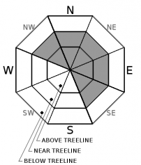
Last night brought a third round of potential new wind slab formation as SW winds increased late yesterday through last night. Ridgetop areas observed yesterday held a foot or more of recent storm snow that was available for wind transport. Last nights winds are expected to have redistributed this snow on the ground creating new wind slabs in near treeline and above treeline areas on NW-N-NE-E-SE aspects. Avalanche size up to D2 is possible (large enough to bury or injure a person).

Human triggered and naturally occurring wind slab avalanches were reported on Thursday and Friday. Look for signs of recently wind drifted snow in the form of cornices, wind pillows, and wind sculpted snow surfaces. Use these clues to identify and avoid areas of potentially unstable wind slab.

Avalanche Problem 2: Persistent Slab
  • Type ?
  • Aspect/Elevation ?
  • Likelihood ?
    Certain
    Very Likely
    Likely
    Possible
    Unlikely
  • Size ?
    Historic
    Very Large
    Large
    Small

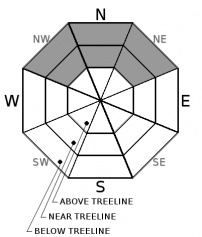
Hang in there and continue to pay attention to the changing details of this avalanche problem despite prolonged messaging. Continued concern is focused on a near crust facet layer that was observed 8 to 12 inches below the old snow/storm snow interface in the Carson Pass area. This weak layer was observed pre storm at Crater Lake, Meiss Meadows, Elephants Hump, and Squaw Ridge. Limited data as to the stability of this old snow weak layer following new snow loading is leading to increased uncertainty. Near treeline and below treeline areas on NW-N-NE aspects is were this avalanche problem may exist. Avalanche size to D2 is anticipated with isolated possibility to size D3.

Look for and avoid avalanche terrain in any areas where snow surface cracking, snowpack collapse with a possible whumpfing sound, and/or unstable snowpit test results are occurring.

Concern for this avalanche problem continues to decrease on a regional scale as the deeply buried facet layer from December and the now unreactive buried surface hoar are no longer the main focus of this avalanche problem. Concern remains elevated for the Carson Pass area and for any yet to be observed areas where this same near crust facet layer exists.


Avalanche Problem 3: Loose Wet
  • Type ?
  • Aspect/Elevation ?
  • Likelihood ?
    Certain
    Very Likely
    Likely
    Possible
    Unlikely
  • Size ?
    Historic
    Very Large
    Large
    Small

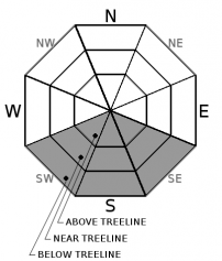
As air temperatures at the mid and upper elevations climb above freezing today, loose wet avalanche activity will become possible on SW-S-SE aspects. Natural roller balls may occur as snow falls off of rocks and trees onto steeper slopes. Small (size D1) human triggered loose wet avalanches will become possible as daytime warming progresses. If warming today is not quite sufficient to get this avalanche problem going, additional warming on Sunday will likely get it started.

recent observations

* A skier or snowboarder triggered wind slab avalanche occurred Friday in the Bronco Chutes of Relay Peak (Mount Rose area) This avalanche occurred in response to a ski cut in complex above treeline terrain on a NW aspect with an approximate slope angle of 45 degrees. The crown was reported as 12 to 16 inches deep. Avalanche size was reported at D2 (large enough to bury or injure a person).

* A second potential wind slab avalanche was noted Friday in the Bronco Chutes area but lighting and distance made discerning details difficult.

* Natural wind slab avalanches were reported Thursday from The Far East Ridge of Tamarack Peak (Mount Rose area) and from the south end of Andesite Ridge (Donner Summit area). In both cases, cornice fall may have been the trigger. Debris were covered with new snow indicating that the avalanches had occurred either Wednesday night or very early Thursday morning.

* Snowpit data targeting buried surface hoar was collected Friday from sites where it was confirmed to exist pre storm on Silver Peak (Pole Creek area) and on Castle Pass (Donner Summit area). In both areas the surface hoar was bonded into the snowpack and no longer produced failures in snowpit tests.

Weather and CURRENT CONDITIONS
weather summary

A weather system passing by to the north of the forecast area increased SW winds and cloud cover last night. Ridgetop winds are decreasing this morning with decreasing cloud cover expected by this afternoon. Air temperatures are forecast to climb above freezing today for areas above 7,000'. A weak NE winds event is expected for tonight. Additional air temperature warming above 7,000' is forecast for Sunday as high pressure builds.

CONDITIONS ALONG THE SIERRA CREST BETWEEN 8200 FT. AND 9200 FT. IN THE LAST 24 HOURS
6am temperature: 18 to 24 deg. F.
Max. temperature: 21 to 31 deg. F.
Average ridgetop wind direction: SW
Average ridgetop wind speed: 29 mph
Maximum ridgetop wind gust: 51 mph
New snowfall: 0 inches
Total snow depth: 32 to 60 inches
Two-Day Mountain Weather Forecast Produced in partnership with the Reno NWS
For 7000 ft. to 8000 ft.
Saturday Saturday Night Sunday
Weather: Mostly cloudy to partly cloudy skies. Partly cloudy skies. Partly cloudy skies, becoming sunny.
Temperatures: 40 to 45 deg. F. 26 to 35 deg. F. 48 to 53 deg. F.
Mid Slope Winds: SW NE Variable
Wind Speed: 10 to 15 mph in the morning, becoming light. Gusts up to 35 mph. Light winds Light winds
Expected snowfall: 0 0 0
For 8000 ft. to 9000 ft.
Saturday Saturday Night Sunday
Weather: Mostly cloudy to partly cloudy skies. Partly cloudy skies. Partly cloudy skies, becoming sunny.
Temperatures: 36 to 41 deg. F. 26 to 31 deg. F. 44 to 49 deg. F.
Ridge Top Winds: SW NE Variable
Wind Speed: 20 to 30 mph. Gusts to 55 mph decreasing to 45 mph in the afternoon. 10 to 15 mph in the evening, becoming light. Gusts up to 35 mph. Light winds. Gust up to 30 mph in the morning.
Expected snowfall: 0 0 0
Disclaimer

This avalanche advisory is provided through a partnership between the Tahoe National Forest and the Sierra Avalanche Center. This advisory covers the Central Sierra Nevada Mountains between Yuba Pass on the north and Ebbetts Pass on the south. Click here for a map of the forecast area. This advisory applies only to backcountry areas outside established ski area boundaries. This advisory describes general avalanche conditions and local variations always occur. This advisory expires 24 hours after the posted time unless otherwise noted. The information in this advisory is provided by the USDA Forest Service who is solely responsible for its content.

For a recorded version of the Avalanche Advisory call (530) 587-3558 x258