


For 7000 ft. to 8000 ft.
| Monday | Monday Night | Tuesday | |
|---|---|---|---|
| Weather: | Partly sunny this morning becoming mostly cloudy by this afternoon | Mostly cloudy with clouds starting to decrease after midnight | Partly cloudy becoming mostly sunny |
| Temperatures: | 48 to 54 deg. F. | 30 to 35 deg. F. | 49 to 55 deg. F. |
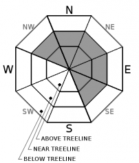
| Mid Slope Winds: | Variable | Southwest | Southwest |
| Wind Speed: | Light with gusts to 25 mph in the afternoon | Light increasing to 10 to 15 mph with gusts to 30 after midnight | 15 to 20 mph with gusts to 40 mph |
| Expected snowfall: | 0 | 0 | 0 |
For 8000 ft. to 9000 ft.
| Monday | Monday Night | Tuesday | |
|---|---|---|---|
| Weather: | Partly sunny this morning becoming mostly cloudy by this afternoon | Mostly cloudy with clouds starting to decrease after midnight | Partly cloudy becoming mostly sunny |
| Temperatures: | 46 to 51 deg. F. | 30 to 35 deg. F. | 44 to 50 deg. F. |
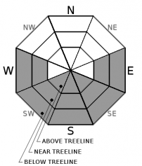
| Ridge Top Winds: | Southwest | Southwest | Southwest |
| Wind Speed: | 15 to 25 mph with gusts to 35 mph in the afternoon | 20 to 30 mph with gusts to 40 mph increasing to 55 mph after midnight | 20 to 35 mph with gusts to 60 mph |
| Expected snowfall: | 0 | 0 | 0 |


