THIS AVALANCHE FORECAST EXPIRED ON March 2, 2018 @ 6:50 am
Avalanche Forecast published on March 1, 2018 @ 6:50 am
Issued by Brandon Schwartz - Tahoe National Forest

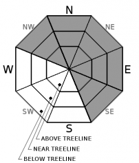
HIGH avalanche danger will occur today for all elevations. An avalanche warning is in effect through 7 am Friday. Travel in or below avalanche terrain is not recommended. If you choose to go out into the backcountry today, please create and closely follow a clear and detailed plan to travel only on slopes less than 30 degrees in slope angle without any exposure to steeper terrain above. Poor visibility may make navigation and terrain recognition very difficult.

4. High

?

Above Treeline
Very dangerous avalanche conditions. Travel in avalanche terrain not recommended.

4. High

?

Near Treeline
Very dangerous avalanche conditions. Travel in avalanche terrain not recommended.

4. High

?

Below Treeline
Very dangerous avalanche conditions. Travel in avalanche terrain not recommended.
    Very dangerous avalanche conditions. Travel in avalanche terrain not recommended.
Avalanche Problem 1: Wind Slab
  • Type ?
  • Aspect/Elevation ?
  • Likelihood ?
    Certain
    Very Likely
    Likely
    Possible
    Unlikely
  • Size ?
    Historic
    Very Large
    Large
    Small

Feet of new snow combined with wind transport today and tonight will create widespread areas of large unstable wind slabs mainly near and above treeline on NW-N-NE-E-SE aspects. In more isolated areas wind slabs could form below treeline due to the strong to gale force winds and the duration of this storm event. Potential avalanche size is expected to quickly reach D2 to D3 today with isolated size D4 possible as the storm progresses*.

Avalanches could be long running and move through mature stands of trees on the valley floor. Travel in or below avalanche terrain is not recommended. Identify and avoid avalanche terrain. Poor visibility may not allow for the proximity to avalanche terrain to be recognized without the proper use of map and compass, gps, etc.

*Avalanche size D2 could bury, injure, or kill a person. Avalanche size D3 could bury and destroy a car, damage a truck, destroy a wood frame house, or break a few trees. Avalanche size D4 could destroy a railway car, large truck, several buildings, or a substantial amount of forest.

Avalanche Problem 2: Storm Slab
  • Type ?
  • Aspect/Elevation ?
  • Likelihood ?
    Certain
    Very Likely
    Likely
    Possible
    Unlikely
  • Size ?
    Historic
    Very Large
    Large
    Small

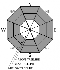
High intensity snowfall with accumulation rates of 2+ inches per hour will cause rapid loading in wind protected areas. This will lead to storm slab development in near treeline and below treeline areas on all aspects. Potential avalanche size is expected to reach D2 to D3.

Travel in avalanche terrain is not recommended. Avalanches initiating in open areas below treeline or in areas of widely spaced trees could run significant distances through forested terrain. In order to anchor the snowpack in place, trees will need to be too closely spaced to travel thorough on skis or a snowmobile. Simply "staying in the trees" may not be a successful tactic for avoiding avalanches today. Slope angle is the critical factor.


Avalanche Problem 3: Deep Slab
  • Type ?
  • Aspect/Elevation ?
  • Likelihood ?
    Certain
    Very Likely
    Likely
    Possible
    Unlikely
  • Size ?
    Historic
    Very Large
    Large
    Small

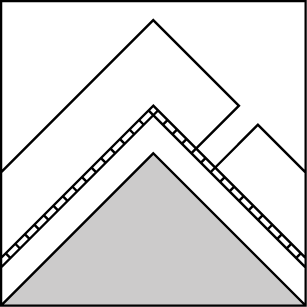
Throughout the forecast area on near treeline and below treeline NW-N-NE aspects, a layer of faceted snow was observed around 1 foot below the snow surface prior to the start of the current snowfall event. In isolated areas, snowpits tests have clearly indicated that this layer will not respond well to rapid new snow loading. Failure of this layer will lead to deep slab avalanches.

As this storm progresses and wind slabs and possibly storm slabs will exceed 3 feet in slab thickness, these avalanche problems could take on deep slab characteristics (failing deeper, wider, and more destructive than typically anticipated) and not necessarily triggered by the first person on the slope. Travel in avalanche terrain is not recommended.

recent observations

* Several wind slabs avalanches were reported this past week from around the forecast area. More details are available in the specific observations section of this website.

* A potentially problematic layer of old near surface facets and/or near crust facets has been observed throughout the forecast area near treeline and below treeline on NW-N-NE aspects. This layer had around 1 foot of snow on top of it prior to the start of this storm. In isolated areas, snowpit tests have indicated that this layer will react poorly to rapid new snow loading.

Weather and CURRENT CONDITIONS
weather summary

A powerful storm system is moving into the forecast area this morning. Snowfall began last night and is expected to increase in intensity this morning. New snowfall amount of 1.5 to 4 feet are expected ever the next 24 hours for areas above 7,000'. Strong to gale force S to SW winds are forecast for the ridgetops today with gusts to 125 mph. Snowfall intensity is expected to decrease on Friday with ongoing accumulating snowfall and strong SW winds.

CONDITIONS ALONG THE SIERRA CREST BETWEEN 8200 FT. AND 9200 FT. IN THE LAST 24 HOURS
6am temperature: 19 to 24 deg. F.
Max. temperature: 21 to 33 deg. F.
Average ridgetop wind direction: SW
Average ridgetop wind speed: 46 mph
Maximum ridgetop wind gust: 81 mph
New snowfall: 4 to 6 inches
Total snow depth: 39 to 66 inches
Two-Day Mountain Weather Forecast Produced in partnership with the Reno NWS
For 7000 ft. to 8000 ft.
Thursday Thursday Night Friday
Weather: Cloudy skies with high intensity snowfall. Cloudy skies with high intensity snowfall. Cloudy skies with snow.
Temperatures: 30 to 35 deg. F. 16 to 21 deg. F. 21 to 26 deg. F.
Mid Slope Winds: S to SW SW SW
Wind Speed: 25 to 40 mph. Gusts to 70 mph increasing to 85 mph in the afternoon. 25 to 35 mph with gusts to 75 mph. 15 to 25 mph with gusts to 50 mph.
Expected snowfall: LIkely 10 to 18 in. | Small chance 18 to 24 Likely 12 to 20 in. | Small chance 6 to 12 4 to 8
For 8000 ft. to 9000 ft.
Thursday Thursday Night Friday
Weather: Cloudy skies with high intensity snowfall. Cloudy skies with high intensity snowfall. Cloudy skies with snow.
Temperatures: 26 to 31 deg. F. 12 to 18 deg. F. 17 to 23 deg. F.
Ridge Top Winds: S to SW SW SW
Wind Speed: 40 to 60 mph. Gusts to 105 mph increasing to 125 mph in the afternoon. 35 to 55 mph with gusts to 115 mph. 30 to 45 mph. Gusts to 85 mph decreasing to 75 mph in the afternoon.
Expected snowfall: Likely 11 to 19 in. Small chance 19 to 26 Likely 13 to 21 in. | Small chance 7 to 13 4 to 10
Disclaimer

This avalanche advisory is provided through a partnership between the Tahoe National Forest and the Sierra Avalanche Center. This advisory covers the Central Sierra Nevada Mountains between Yuba Pass on the north and Ebbetts Pass on the south. Click here for a map of the forecast area. This advisory applies only to backcountry areas outside established ski area boundaries. This advisory describes general avalanche conditions and local variations always occur. This advisory expires 24 hours after the posted time unless otherwise noted. The information in this advisory is provided by the USDA Forest Service who is solely responsible for its content.

For a recorded version of the Avalanche Advisory call (530) 587-3558 x258