


For 7000 ft. to 8000 ft.
| Friday | Friday Night | Saturday | |
|---|---|---|---|
| Weather: | Snow with a slight chance of thunderstorms in the afternoon | Snow with a slight chance of thunderstorms in the evening. | Mostly cloudy with snow showers likely |
| Temperatures: | 23 to 28 deg. F. | 12 to 17 deg. F. | 26 to 31 deg. F. |
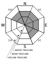
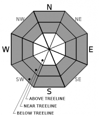
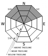
| Mid Slope Winds: | Southwest | Southwest | Southwest |
| Wind Speed: | 15 to 25 mph with gusts to 50 mph | 10 to 15 mph with gusts to 30 mph becoming light overnight | 10 to 15 mph with gusts to 35 in the morning becoming light in the afternoon |
| Expected snowfall: | 5 to 12 | 2 to 6 | 1 to 3 |
For 8000 ft. to 9000 ft.
| Friday | Friday Night | Saturday | |
|---|---|---|---|
| Weather: | Snow with a slight chance of thunderstorms in the afternoon | Snow with a slight chance of thunderstorms in the evening. | Mostly cloudy with snow showers likely |
| Temperatures: | 19 to 24 deg. F. | 10 to 16 deg. F. | 21 to 27 deg. F. |
| Ridge Top Winds: | Southwest | Southwest | Southwest |
| Wind Speed: | 25 to 40 mph with gusts to 85 mph decreasing to 20 to 30 mph with gusts to 75 mph in the afternoon | 15 to 25 mph with gusts to 55 mph decreasing to 45 mph after midnight | 20 to 30 mph with gusts to 50 mph in the morning becoming light in the afternoon |
| Expected snowfall: | 8 to 15 | 2 to 7 | 1 to 4 |


