


For 7000 ft. to 8000 ft.
| Sunday | Sunday Night | Monday | |
|---|---|---|---|
| Weather: | Sunny skies, becoming partly cloudy. | Mostly cloudy skies. | Mostly cloudy skies, becoming partly cloudy. |
| Temperatures: | 31 to 36 deg. F. | 15 to 20 deg. F. | 36 to 41 deg. F. |
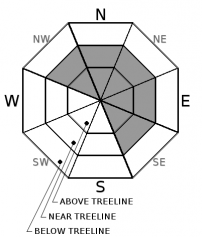
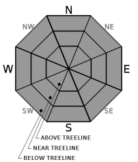
| Mid Slope Winds: | Variable | Variable | S |
| Wind Speed: | Light winds | Light winds | Light winds |
| Expected snowfall: | 0 | 0 | 0 |
For 8000 ft. to 9000 ft.
| Sunday | Sunday Night | Monday | |
|---|---|---|---|
| Weather: | Sunny skies, becoming partly cloudy. | Mostly cloudy skies. | Mostly cloudy skies, becoming partly cloudy. |
| Temperatures: | 26 to 32 deg. F. | 14 to 19 deg. F. | 32 to 38 deg. F. |
| Ridge Top Winds: | Variable | S | S |
| Wind Speed: | Light winds | Light winds becoming 10 to 15 mph with gusts to 30 mph after midnight. | 10 to 15 mph with gusts to 25 mph. |
| Expected snowfall: | 0 | 0 | 0 |


