


For 7000 ft. to 8000 ft.
| Friday | Friday Night | Saturday | |
|---|---|---|---|
| Weather: | Mostly sunny this morning with snow in the afternoon | Snow | Cloudy with snow showers likely |
| Temperatures: | 22 to 27 deg. F. | 13 to 18 deg. F. | 20 to 25 deg. F. |
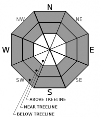
| Mid Slope Winds: | Southwest | Southwest | Southwest |
| Wind Speed: | 20 to 30 mph with gusts to 60 mph decreasing to 50 mph in the afternoon | 15 to 25 mph with gusts to 45 mph | Light in the morning increasing to 10 to 15 mph in the afternoon |
| Expected snowfall: | 4 to 10 | 7 to 13 | 1 to 3 |
For 8000 ft. to 9000 ft.
| Friday | Friday Night | Saturday | |
|---|---|---|---|
| Weather: | Mostly sunny this morning with snow in the afternoon | Snow | Cloudy with snow showers likely |
| Temperatures: | 17 to 23 deg. F. | 9 to 15 deg. F. | 15 to 21 deg. F. |
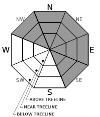
| Ridge Top Winds: | Southwest | Southwest | Southwest |
| Wind Speed: | 30 to 50 mph with gusts to 115 mph decreasing to 95 mph in the afternoon | 25 to 40 mph with gusts to 80 mph decreasing to 70 mph after midnight | 15 to 25 mph with gusts to 55 mph decreasing to 35 mph in the afternoon |
| Expected snowfall: | 5 to 11 | 8 to 14 | 1 to 4 |


