


For 7000 ft. to 8000 ft.
| Tuesday | Tuesday Night | Wednesday | |
|---|---|---|---|
| Weather: | Mostly cloudy. Slight chance of snow in the afternoon. | Cloudy. Rain and snow likely. | Cloudy. Rain and snow likely in the morning then rain and snow in the afternoon. |
| Temperatures: | 40 to 46 deg. F. | 32 to 37 deg. F. | 38 to 43 deg. F. |
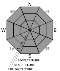
| Mid Slope Winds: | SW | SW | SW |
| Wind Speed: | 10 to 15mph in the morning becoming light. Gusts up to 35mph. | 10 to 15mph with gusts to 30mph increasing to 20 to 30mph with gusts to 50mph after midnight. | 20 to 30mph with gusts to 50mph. |
| Expected snowfall: | Up to 1 | 2 to 5 | 1 to 3 |
For 8000 ft. to 9000 ft.
| Tuesday | Tuesday Night | Wednesday | |
|---|---|---|---|
| Weather: | Mostly cloudy. Chance of snow in the afternoon. | Cloudy. Snow and rain likely. | Cloudy. Snow and rain likely in the morning then snow and rain in the afternoon. |
| Temperatures: | 36 to 42 deg. F. | 30 to 36 deg. F. | 34 to 39 deg. F. |
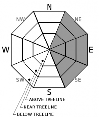
| Ridge Top Winds: | SW | SW | SW |
| Wind Speed: | 20 to 30mph. Gusts to 60mph decreasing to 50mph in the afternoon. | 25 to 40mph with gusts to 70mph increasing to 35 to 55mph with gusts to 95mph after midnight. | 30 to 50mph with gusts to 85mph. |
| Expected snowfall: | Up to 1 | 2 to 5 | 1 to 5 |


