


For 7000 ft. to 8000 ft.
| Wednesday | Wednesday Night | Thursday | |
|---|---|---|---|
| Weather: | Cloudy. Chance of snow. Rain likely through the day. | Cloudy. Rain and snow. | Cloudy. Rain and snow. |
| Temperatures: | 40 to 45 deg. F. | 32 to 37 deg. F. | 34 to 39 deg. F. |
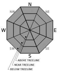
| Mid Slope Winds: | SW | S | SW |
| Wind Speed: | 15 to 25mph with gusts to 45mph. | 15 to 30mph with gusts to 50mph. | 15 to 25mph with gusts to 45mph. |
| Expected snowfall: | .25 to .50 | .60 to 1.10'' liquid | Possible 3 to 9 | 7 to 15 |
For 8000 ft. to 9000 ft.
| Wednesday | Wednesday Night | Thursday | |
|---|---|---|---|
| Weather: | Cloudy. Rain and snow likely. | Cloudy. Snow and rain. | Cloudy. Rain in the morning, snow through the day. |
| Temperatures: | 36 to 41 deg. F. | 29 to 35 deg. F. | 31 to 36 deg. F. |
| Ridge Top Winds: | SW | SW | S |
| Wind Speed: | 30 to 45mph with gusts to 85mph. | 35 to 55mph. Gusts to 90mph increasing to 100mph after midnight. | 35 to 55mph with gusts to 115mph, shifting to the SW 45 to 60mph with gusts to 100mph in the afternoon. |
| Expected snowfall: | 2 to 6 | 5 to 11 | 12 to 20 |


