


For 7000 ft. to 8000 ft.
| Friday | Friday Night | Saturday | |
|---|---|---|---|
| Weather: | Sunny in the morning becoming partly cloudy during the day. | Partly cloudy becoming mostly cloudy with scattered snow showers in the evening and widespread snow showers after midnight. | Mostly cloudy with widespread snow showers |
| Temperatures: | 33 to 39 deg. F. | 21 to 26 deg. F. | 27 to 32 deg. F. |
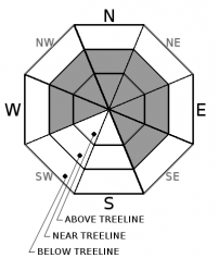
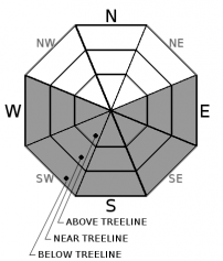
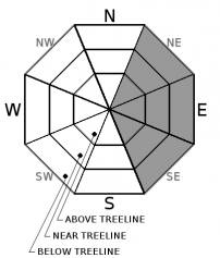
| Mid Slope Winds: | Southwest | Southwest | Southwest |
| Wind Speed: | 15 to 25 mph with gusts to 35 mph | 20 to 30 mph with gusts to 45 mph | 15 to 25 mph with gusts to 40 mph |
| Expected snowfall: | 0 | 1 to 3 | 1 to 3 |
For 8000 ft. to 9000 ft.
| Friday | Friday Night | Saturday | |
|---|---|---|---|
| Weather: | Sunny in the morning becoming partly cloudy during the day. | Partly cloudy becoming mostly cloudy with scattered snow showers in the evening and widespread snow showers after midnight. | Mostly cloudy with widespread snow showers |
| Temperatures: | 27 to 35 deg. F. | 17 to 23 deg. F. | 22 to 28 deg. F. |
| Ridge Top Winds: | Southwest | Southwest | Southwest |
| Wind Speed: | 30 to 45 mph with gusts to 55 mph increasing to 65 mph in the afternoon | 30 to 45 mph with gusts to 70 mph | 20 to 35 mph with gusts to 55 mph |
| Expected snowfall: | 0 | 2 to 4 | 2 to 5 |


