


For 7000 ft. to 8000 ft.
| Sunday | Sunday Night | Monday | |
|---|---|---|---|
| Weather: | Mostly cloudy skies, becoming partly cloudy. Scattered snow showers. | Mostly cloudy skies, becoming clear. Isolated snow showers in the evening. | Sunny skies, becoming partly cloudy. |
| Temperatures: | 26 to 31 deg. F. | 10 to 15 deg. F. | 30 to 35 deg. F. |
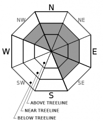
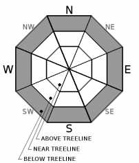
| Mid Slope Winds: | SW to W | Variable | NE |
| Wind Speed: | 10 to 20 mph with gusts to 30 mph in the morning, decreasing to around 10 mph. | Light winds | Up to 10 mph. |
| Expected snowfall: | 0 to trace | 0 to trace | 0 |
For 8000 ft. to 9000 ft.
| Sunday | Sunday Night | Monday | |
|---|---|---|---|
| Weather: | Mostly cloudy skies, becoming partly cloudy. Scattered snow showers. | Mostly cloudy skies, becoming clear. Isolated snow showers in the evening. | Sunny skies, becoming partly cloudy. |
| Temperatures: | 21 to 27 deg. F. | 8 to 13 deg. F. | 24 to 30 deg. F. |
| Ridge Top Winds: | SW | NE | NE |
| Wind Speed: | 20 to 35 mph with gusts to 55 mph, decreasing to 10 to 15 mph with gusts to 30 mph in the afternoon. | Light winds, becoming 10 to 15 mph with gust to 30 mph. | 10 to 20 mph. Gusts up to 30 mph in the afternoon. |
| Expected snowfall: | 0 to trace | 0 to trace | 0 |


