THIS AVALANCHE FORECAST EXPIRED ON March 29, 2018 @ 6:50 am
Avalanche Forecast published on March 28, 2018 @ 6:50 am
Issued by Steve Reynaud - Tahoe National Forest

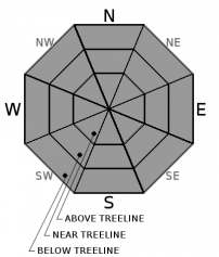
MODERATE avalanche danger will continue today due to a loose wet avalanche problem at all elevations.  Wind slabs have become unlikely but not impossible today in isolated areas in near treeline and above treeline terrain.  Identify areas of unstable snow and avoid specific terrain features. 

2. Moderate

?

Above Treeline
Heightened avalanche conditions on specific terrain features. Evaluate snow and terrain carefully; identify features of concern.

2. Moderate

?

Near Treeline
Heightened avalanche conditions on specific terrain features. Evaluate snow and terrain carefully; identify features of concern.

2. Moderate

?

Below Treeline
Heightened avalanche conditions on specific terrain features. Evaluate snow and terrain carefully; identify features of concern.
    Heightened avalanche conditions on specific terrain features. Evaluate snow and terrain carefully; identify features of concern.
Avalanche Problem 1: Loose Wet
  • Type ?
  • Aspect/Elevation ?
  • Likelihood ?
    Certain
    Very Likely
    Likely
    Possible
    Unlikely
  • Size ?
    Historic
    Very Large
    Large
    Small

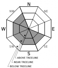
As daytime warming occurs today, loose wet avalanches will become possible on all aspects and elevations.  An additional 5 to 10 degrees of warming today with decreasing winds will make loose wet activity more widespread.  Roller balls and pinwheels are expected on all aspects, with the possibility of larger loose wet avalanches that could injure or bury an backcountry user-size D2.

As the surface snow in your area becomes wet and heavy, it's time to change aspects or move on.  Roller balls will be an indication that the surface snow is loosing strength and that larger loose wet avalanches could occur.

Avalanche Problem 2: Wind Slab
  • Type ?
  • Aspect/Elevation ?
  • Likelihood ?
    Certain
    Very Likely
    Likely
    Possible
    Unlikely
  • Size ?
    Historic
    Very Large
    Large
    Small

Wind slabs have become unlikely but not impossible on SE-S-SW-W-NW aspects in near and above treeline terrain.  NE winds are forecasted to decrease over the next couple days into the light to moderate range.  Small wind slabs could still exist in steep complex terrain features and have either soft or hard slab characteristics.

Look for signs of past blowing snow, snow surface clues, cornice formation, or wind pillows.  Avoid steep wind loaded terrain.

recent observations

* Observations from yesterday on Mt. Tallac (Desolation Wilderness) showed a developing loose wet avalanche problem.  NE winds were keeping it cool above 9000' with wet snow on all aspects below 8000'.  Roller balls and larger loose wet avalanches were observed in steep sun exposed terrain.  New wind slab development was limited in this area. 

* A widespread deep slab avalanche cycle occurred during the March 20 - 22 storm cycle on N-NE-E aspects both above and below treeline in the 7,000' to 10,000' elevation range throughout the forecast region. No reports of post storm deep slab avalanches have been received.  Check out the observation page for more details and photos. 

Weather and CURRENT CONDITIONS
weather summary

Warming temperatures will continue in our area with a ridge of high pressure over California.  Some high cloud cover will be possible especially as we near the weekend.  NE winds will decrease with gusts up to 30mph over the higher peaks and ridges.  Temperatures are expected to be 10 to 15 degrees above average by Friday.

CONDITIONS ALONG THE SIERRA CREST BETWEEN 8200 FT. AND 9200 FT. IN THE LAST 24 HOURS
6am temperature: 30 to 36 deg. F.
Max. temperature: 43 deg. F.
Average ridgetop wind direction: NE
Average ridgetop wind speed: 10 to 35 mph
Maximum ridgetop wind gust: 53 mph
New snowfall: 0 inches
Total snow depth: 77 to 111 inches
Two-Day Mountain Weather Forecast Produced in partnership with the Reno NWS
For 7000 ft. to 8000 ft.
Wednesday Wednesday Night Thursday
Weather: Sunny Clear Sunny
Temperatures: 49 to 54 deg. F. 27 to 32 deg. F. 52 to 57 deg. F.
Mid Slope Winds: E
Wind Speed: Up to 10mph. Light winds Light winds
Expected snowfall: 0 0 0
For 8000 ft. to 9000 ft.
Wednesday Wednesday Night Thursday
Weather: Sunny Clear Sunny
Temperatures: 44 to 50 deg. F. 26 to 31 deg. F. 47 to 53 deg. F.
Ridge Top Winds: NE NE E
Wind Speed: 15 to 25mph with gusts to 35mph in the morning decreasing to 10 to 15mph. 10 to 15mph with gusts to 30mph. 10 to 15mph. Gusts up to 30mph in the morning.
Expected snowfall: 0 0 0
Disclaimer

This avalanche advisory is provided through a partnership between the Tahoe National Forest and the Sierra Avalanche Center. This advisory covers the Central Sierra Nevada Mountains between Yuba Pass on the north and Ebbetts Pass on the south. Click here for a map of the forecast area. This advisory applies only to backcountry areas outside established ski area boundaries. This advisory describes general avalanche conditions and local variations always occur. This advisory expires 24 hours after the posted time unless otherwise noted. The information in this advisory is provided by the USDA Forest Service who is solely responsible for its content.

For a recorded version of the Avalanche Advisory call (530) 587-3558 x258