THIS AVALANCHE FORECAST EXPIRED ON March 9, 2018 @ 6:59 am
Avalanche Forecast published on March 8, 2018 @ 6:59 am
Issued by Andy Anderson - Tahoe National Forest - Sierra Avalanche Center

Even though deep slab avalanches have become more difficult to trigger and are now unlikely in most areas, they may remain possible in some specific terrain. The consequences of such an avalanche would still be dire. Some loose wet avalanche problems may also become possible today. These issues will keep the avalanche danger at MODERATE

2. Moderate

?

Above Treeline
Heightened avalanche conditions on specific terrain features. Evaluate snow and terrain carefully; identify features of concern.

2. Moderate

?

Near Treeline
Heightened avalanche conditions on specific terrain features. Evaluate snow and terrain carefully; identify features of concern.

2. Moderate

?

Below Treeline
Heightened avalanche conditions on specific terrain features. Evaluate snow and terrain carefully; identify features of concern.
    Heightened avalanche conditions on specific terrain features. Evaluate snow and terrain carefully; identify features of concern.
Avalanche Problem 1: Deep Slab
  • Type ?
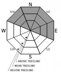
  • Aspect/Elevation ?
  • Likelihood ?
    Certain
    Very Likely
    Likely
    Possible
    Unlikely
  • Size ?
    Historic
    Very Large
    Large
    Small

As the snow above the persistent weak layer has become stronger and as the persistent weak layer has started to adjust to the load above it, deep slab avalanches have become more difficult to trigger and are now unlikely in most areas. In some specific areas where the weak layer remains closer to the surface, triggering one of the avalanches may remain possible. These areas could include places where a shallower overall snowpack exists or areas where trigger points like rocks, cliffy areas, single trees, stumps, etc exist on slopes with a deeper snowpack. On these slopes, several tracks could exist before a person finds the trigger point that would release the entire slope. While the possibility of triggering one of these avalanches has decreased, the consequences of these deep slabs would still be very serious.

Typical signs of instability do not usually accompany deep slabs. Often triggering a large avalanche represents the first sign of instability. Due to the uncertainty surrounding deep slab avalanches and the high consequences associated with them, making travel plans that focus on slopes where this problem is least likely to exist still represents a prudent choice. Lower angle northerly aspects still offer good recreation conditions.  

Avalanche Problem 2: Loose Wet
  • Type ?
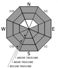
  • Aspect/Elevation ?
  • Likelihood ?
    Certain
    Very Likely
    Likely
    Possible
    Unlikely
  • Size ?
    Historic
    Very Large
    Large
    Small

Loose wet instabilities will become possible on sun-exposed E-SE-S-SW-W aspects as the day warms up. Some loose wet instabilities could also form on northerly aspects if any rain falls on the existing snowpack or if cloud cover allows those aspects to warm up. Rollerballs, pinwheels, and small loose wet point releases should comprise most of the loose wet instabilities today, but a few larger loose wet avalanches may be possible. The amount of loose wet instability that forms today will depend on the mix of sun, cloud cover, wind, and precipitation that actually occurs.

recent observations

* Snowpit tests targetting the facet layer buried 1 to 1.5 m deep in the snowpack yesterday on Silver Peak (north of Squaw) and Donner Peak (Donner Summit) indicated that triggering this layer has become more difficult, but that if it does break the resulting fracture could still propagate along the persistent weak layer. A snowpit on Waterhouse Peak (Luther Pass) also revealed this layer about 1 m below the surface.

* Other snowpit tests from across the forecast area earlier in the week showed more unstable results on this layer. Several natural and human-triggered deep slab avalanches occurred during and after the storm. 

* Loose wet instabilities including roller balls and pinwheels started occurring on sun-exposed slopes below 7500 ft. on Donner Peak and Silver Peak yesterday afternoon. Snow surfaces on all but the true north aspects above 7500 ft. started to become wet and sticky. 

Weather and CURRENT CONDITIONS
weather summary

A low-pressure system focused on the Pacific NW has brought stronger southwest winds and increased cloud cover to the forecast area. These clouds and winds should remain over the region through tomorrow. This system also brings a small chance of some snow and rain showers to the area this morning and tomorrow with snow levels between 6000 and 7000 ft. If any precipitation does fall, accumulation should remain limited to less than .1 inches of water or less than 1 inch of snow. 

CONDITIONS ALONG THE SIERRA CREST BETWEEN 8200 FT. AND 9200 FT. IN THE LAST 24 HOURS
6am temperature: 26 to 33 deg. F.
Max. temperature: 40 to 45 deg. F.
Average ridgetop wind direction: Southwest
Average ridgetop wind speed: 25 to 45 mph
Maximum ridgetop wind gust: 71 mph
New snowfall: 0 inches
Total snow depth: 52 to 82 inches
Two-Day Mountain Weather Forecast Produced in partnership with the Reno NWS
For 7000 ft. to 8000 ft.
Thursday Thursday Night Friday
Weather: Partly cloudy with a slight (10%) chance of snow showers in the morning. Snow level starting at 6000 ft and increasing to 7000 ft. + during the day. Partly cloudy becoming mostly cloudy Mostly cloudy with a chance of showers. Snow level starting at 6000 ft and increasing to 6500 ft. + during the day.
Temperatures: 42 to 48 deg. F. 26 to 31 deg. F. 40 to 45 deg. F.
Mid Slope Winds: Southwest Southwest Southwest
Wind Speed: 15 to 25 mph with gusts to 50 mph 10 to 20 mph with gusts to 40 mph 10 to 20 mph with gusts to 40 mph
Expected snowfall: trace 0 trace
For 8000 ft. to 9000 ft.
Thursday Thursday Night Friday
Weather: Partly cloudy with a slight (10%) chance of snow showers in the morning. Partly cloudy becoming mostly cloudy Mostly cloudy with a chance of showers.
Temperatures: 30 to 40 deg. F. 24 to 29 deg. F. 30 to 40 deg. F.
Ridge Top Winds: Southwest Southwest Southwest
Wind Speed: 40 to 65 mph with gusts to 90 mph 25 to 35 mph with gusts to 60 mph 20 to 30 mph with gusts to 60 mph
Expected snowfall: trace 0 trace
Disclaimer

This avalanche advisory is provided through a partnership between the Tahoe National Forest and the Sierra Avalanche Center. This advisory covers the Central Sierra Nevada Mountains between Yuba Pass on the north and Ebbetts Pass on the south. Click here for a map of the forecast area. This advisory applies only to backcountry areas outside established ski area boundaries. This advisory describes general avalanche conditions and local variations always occur. This advisory expires 24 hours after the posted time unless otherwise noted. The information in this advisory is provided by the USDA Forest Service who is solely responsible for its content.

For a recorded version of the Avalanche Advisory call (530) 587-3558 x258