THIS AVALANCHE FORECAST EXPIRED ON April 2, 2019 @ 6:46 am
Avalanche Forecast published on April 1, 2019 @ 6:46 am
Issued by Brandon Schwartz - Tahoe National Forest

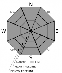
LOW avalanche danger exists for all elevations. Isolated loose wet avalanches may occur today.

1. Low

?

Above Treeline
Generally safe avalanche conditions. Watch for unstable snow on isolated terrain features.

1. Low

?

Near Treeline
Generally safe avalanche conditions. Watch for unstable snow on isolated terrain features.

1. Low

?

Below Treeline
Generally safe avalanche conditions. Watch for unstable snow on isolated terrain features.
    Generally safe avalanche conditions. Watch for unstable snow on isolated terrain features.
Avalanche Problem 1: Loose Wet
  • Type ?
  • Aspect/Elevation ?
  • Likelihood ?
    Certain
    Very Likely
    Likely
    Possible
    Unlikely
  • Size ?
    Historic
    Very Large
    Large
    Small

Loose wet avalanche activity is unlikely today in most areas, but there are issues to keep an eye out for that could lead to isolated instability. Conditions were not ideal for snow surface refreeze last night with above freezing air temperatures and some cloud cover. The snow surface in heavily treed areas may have a refreeze that is weak to nonexistent. Open slopes may have a weak to moderate strength superficial refreeze. Increasing cloud cover today is expected to limit snow surface warming from solar radiation, but light rain on snow below 8,500' will provide a small amount of melt and free water. Use caution if encountering surface wet snow in avalanche terrain. Steep NW-N-NE aspects that receive rain on lingering unconsolidated recent storm snow may be where the most problematic instability occurs today.

Move to low angle terrain if encountering roller balls, pinwheels, or unsupportable wet snow.

Forecast discussion

Forecast new snow amounts today above 8,500' are insufficient to create new problematic wind slabs. If forecast snowfall amounts are exceeded today, consider the presence of this problem in lee areas along ridgelines and below cornice features. This avalanche problem may form by sunrise tomorrow.

recent observations

* Unconsolidated recent storm snow, yet to be affected by melt lingers on steeper N aspects at the mid and upper elevations.

* Breakable to supportable melt-freeze crust exists on the snow surface in sun exposed areas, including on low angle northerly aspects.

* The deeper snowpack remains well bonded with instabilities occurring relatively close to the snow surface.

* No new avalanche activity was reported during the last 24 hours.

Weather and CURRENT CONDITIONS
weather summary

The first in a series of weak to moderate strength storm systems arrives across the forecast area today. Air temperatures are at to above freezing at nearly all locations this morning. Cloud cover is increasing over the region. Light rain and snow are expected to begin sometime late morning to this afternoon with snow levels around 8,500'. Moderate speed SW ridgetop winds are forecast for today, with strong gusts expected tonight. Snow levels are forecast to lower to around 7,000' by sunrise Tuesday with continued precipitation and a slight chance of lightning through the afternoon. After a break in the weather on Wednesday, additional periods of precipitation are forecast to continue into the weekend.

CONDITIONS ALONG THE SIERRA CREST BETWEEN 8200 FT. AND 9200 FT. IN THE LAST 24 HOURS
6am temperature: 32 to 38 deg. F.
Max. temperature: 37 to 50 deg. F.
Average ridgetop wind direction: E shifting to SSW
Average ridgetop wind speed: 19 mph
Maximum ridgetop wind gust: 31 mph
New snowfall: 0 inches
Total snow depth: 110 to 160 inches
Two-Day Mountain Weather Forecast Produced in partnership with the Reno NWS
For 7000 ft. to 8000 ft.
Monday Monday Night Tuesday
Weather: Cloudy. Showers likely in the afternoon. Snow levels 8500 feet. Chance of precipitation is 55%. Cloudy. Showers likely. Snow levels 8500 feet decreasing to 7500 feet after midnight. Chance of precipitation is 70%. Cloudy. Showers through the day. Slight chance of thunderstorms in the afternoon. Snow levels 7000 feet. Chance of precipitation is 80%.
Temperatures: 45 to 51 deg. F. 29 to 34 deg. F. 38 to 44 deg. F.
Mid Slope Winds: Light winds becoming southwest around 15 mph with gusts to 30 mph in the afternoon. Southwest 15 to 20 mph with gusts to 30 mph. Southwest 15 to 25 mph. Gusts up to 35 mph.
Expected snowfall: No accumulation. | SWE = less than 0.10 inch. 70% probability up to 2 inches. 30% probability of 2 to 4 inches. | SWE = up to 0.20 inch. 80% probability up to 2 inches. 20% probability up to 4 inches. | SWE = 0.15-0.40 inch.
For 8000 ft. to 9000 ft.
Monday Monday Night Tuesday
Weather: Cloudy. Showers likely in the afternoon. Snow levels 8500 feet. Chance of precipitation is 55%. Cloudy. Showers likely. Snow levels 8500 feet decreasing to 7500 feet after midnight. Chance of precipitation is 70%. Cloudy. Snow showers through the day. Slight chance of thunderstorms in the afternoon. Snow levels 7000 feet. Chance of precipitation is 80%.
Temperatures: 39 to 47 deg. F. 25 to 30 deg. F. 32 to 40 deg. F.
Ridge Top Winds: Southwest 15 to 25 mph. Gusts up to 30 mph increasing to 45 mph in the afternoon. Southwest 25 to 40 mph with gusts to 70 mph. Southwest 20 to 35 mph with gusts to 60 mph.
Expected snowfall: 60% probability 1 to 2 inches. 40% probability no accumulation. | SWE = less than 0.10 inch. 60% probability up to 3 inches. 40% probability of 2 to 4 inches. | SWE = up to 0.25 inch. 80% probability of up to 3 inches. 20% probability up to 5 inches. | SWE = 0.20-0.45 inch.
Disclaimer

This avalanche forecast is provided through a partnership between the Tahoe National Forest and the Sierra Avalanche Center. This forecast covers the Central Sierra Nevada Mountains between Yuba Pass on the north and Ebbetts Pass on the south. Click here for a map of the forecast area. This forecast applies only to backcountry areas outside established ski area boundaries. This forecast describes general avalanche conditions and local variations always occur. This forecast expires 24 hours after the posted time unless otherwise noted. The information in this forecast is provided by the USDA Forest Service who is solely responsible for its content.

For a recorded version of the avalanche forecast call (530) 587-3558 x258