THIS AVALANCHE FORECAST EXPIRED ON April 12, 2019 @ 6:59 am
Avalanche Forecast published on April 11, 2019 @ 6:59 am
Issued by Andy Anderson - Tahoe National Forest - Sierra Avalanche Center

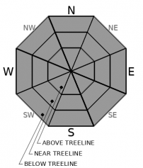
The avalanche danger should remain LOW for all elevations due to a good overnight refreeze and cooler weather with minimal amounts of new snow today. Firm icy surfaces may exist on many open slopes. Use normal caution when traveling in the backcountry. 

1. Low

?

Above Treeline
Generally safe avalanche conditions. Watch for unstable snow on isolated terrain features.

1. Low

?

Near Treeline
Generally safe avalanche conditions. Watch for unstable snow on isolated terrain features.

1. Low

?

Below Treeline
Generally safe avalanche conditions. Watch for unstable snow on isolated terrain features.
    Generally safe avalanche conditions. Watch for unstable snow on isolated terrain features.
Avalanche Problem 1: Normal Caution
  • Type ?
  • Aspect/Elevation ?
  • Likelihood ?
    Certain
    Very Likely
    Likely
    Possible
    Unlikely
  • Size ?
    Historic
    Very Large
    Large
    Small

Several things should work to keep the snow surface mostly frozen today. These include a good overnight refreeze, cooler daytime temperatures, continued northerly winds, and increased cloud cover. As long as the snow surface remains mostly frozen, loose wet instabilities should remain unlikely. Other avalanche problems like wind slabs should also remain unlikely since the forecast only calls for 1 to 2 inches of new snow today.

Expect to find variable conditions with icy crusts on exposed slopes and dust on crust conditions in more sheltered areas. While these firm refrozen conditions may result in fewer hazards from sliding snow, they could mean more potential of long sliding falls for people. 

recent observations

* Yesterday observations from Hawks Peak, Chickadee Ridge, Incline Lake Peak, and the Blue Lakes area all found evidence of a solid refreeze that remained ski and snowmobile supportable into the mid to late afternoon.

* At 2 pm below 8200 ft on a S aspect on Incline Lake Peak, the refrozen crust would still support a person on skis but had weakened to the point where it would not support a person on foot. Shin deep wet snow existed below the thin crust. 

* Variable snow surfaces ranging from firm exposed crusts to "dust on crust" conditions were observed on all aspects and at all elevations yesterday. Lower angle, wind-sheltered slopes had the most consistent conditions.

Weather and CURRENT CONDITIONS
weather summary

Temperatures dipped into the 20's in most places last night and skies should have remained clear long enough for a solid refreeze. Cloud cover should increase today as a small weak disturbance moves into the area. This system could bring some light snow showers to the region with only 1 to 2 inches of accumulation expected today. Snow showers may continue through tonight without much additional accumulation. The weather should begin to start clearing back up tomorrow, but temperatures should remain cooler than normal today and tomorrow.

CONDITIONS ALONG THE SIERRA CREST BETWEEN 8200 FT. AND 9200 FT. IN THE LAST 24 HOURS
6am temperature: 24 to 29 deg. F.
Max. temperature: 33 to 43 deg. F.
Average ridgetop wind direction: NE
Average ridgetop wind speed: 20 to 30 mph
Maximum ridgetop wind gust: 56 mph
New snowfall: 0 inches
Total snow depth: 105 to 155 inches
Two-Day Mountain Weather Forecast Produced in partnership with the Reno NWS
For 7000 ft. to 8000 ft.
Thursday Thursday Night Friday
Weather: Cloudy. Slight chance of snow showers in the morning, then snow showers likely in the afternoon. Snow levels below 7000 feet. Chance of precipitation is 65%. Mostly cloudy. Chance of snow showers in the evening. Snow levels below 7000 feet. Chance of precipitation is 30%. Partly cloudy. Snow levels below 7000 feet. Chance of precipitation is 5%.
Temperatures: 36 to 42 deg. F. 21 to 26 deg. F. 39 to 44 deg. F.
Mid Slope Winds: Light winds becoming west around 15 mph with gusts to 30 mph in the afternoon. Light winds. Light winds becoming northeast around 15 mph with gusts to 25 mph in the afternoon.
Expected snowfall: 60% probability up to 1 inch. 40% probability of 1 to 2 inches. | SWE = less than 0.10 inch. 70% probability up to 1 inch. 30% probability of 1 to 2 inches. | SWE = less than 0.10 inch. No accumulation. | SWE = none.
For 8000 ft. to 9000 ft.
Thursday Thursday Night Friday
Weather: Cloudy. Slight chance of snow showers in the morning, then snow showers likely in the afternoon. Snow levels below 7000 feet. Chance of precipitation is 70%. Mostly cloudy. Chance of snow showers in the evening. Snow levels below 7000 feet. Chance of precipitation is 35%. Partly cloudy then becoming sunny. Snow levels below 7000 feet. Chance of precipitation is 5%.
Temperatures: 29 to 37 deg. F. 17 to 22 deg. F. 33 to 41 deg. F.
Ridge Top Winds: Northwest around 15 mph with gusts to 30 mph. North around 15 mph with gusts to 30 mph. Northeast 15 to 20 mph with gusts to 35 mph.
Expected snowfall: 60% probability up to 2 inches. 40% probability of 2 to 3 inches. | SWE = up to 0.15 inch. 70% probability up to 1 inch. 30% probability of 1 to 2 inches. | SWE = less than 0.10 inch. No accumulation. | SWE = none.
Disclaimer

This avalanche forecast is provided through a partnership between the Tahoe National Forest and the Sierra Avalanche Center. This forecast covers the Central Sierra Nevada Mountains between Yuba Pass on the north and Ebbetts Pass on the south. Click here for a map of the forecast area. This forecast applies only to backcountry areas outside established ski area boundaries. This forecast describes general avalanche conditions and local variations always occur. This forecast expires 24 hours after the posted time unless otherwise noted. The information in this forecast is provided by the USDA Forest Service who is solely responsible for its content.

For a recorded version of the avalanche forecast call (530) 587-3558 x258