THIS AVALANCHE FORECAST EXPIRED ON April 3, 2019 @ 6:54 am
Avalanche Forecast published on April 2, 2019 @ 6:54 am
Issued by Steve Reynaud - Tahoe National Forest

Rain and snow will impact our forecast area today.  MODERATE avalanche danger will exist due to wind slab and loose wet avalanche problems.  Human triggered avalanches will be possible.

2. Moderate

?

Above Treeline
Heightened avalanche conditions on specific terrain features. Evaluate snow and terrain carefully; identify features of concern.

2. Moderate

?

Near Treeline
Heightened avalanche conditions on specific terrain features. Evaluate snow and terrain carefully; identify features of concern.

2. Moderate

?

Below Treeline
Heightened avalanche conditions on specific terrain features. Evaluate snow and terrain carefully; identify features of concern.
    Heightened avalanche conditions on specific terrain features. Evaluate snow and terrain carefully; identify features of concern.
Avalanche Problem 1: Wind Slab
  • Type ?
  • Aspect/Elevation ?
  • Likelihood ?
    Certain
    Very Likely
    Likely
    Possible
    Unlikely
  • Size ?
    Historic
    Very Large
    Large
    Small

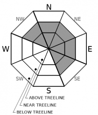
Strong SW winds with additional snow will allow wind slabs to form on NW-N-NE-E-SE aspects in near and above treeline terrain.  Most wind slabs today should be small in size due to limited available snow for wind transport.  In efficient wind loading areas that receive the most new storm snow, wind slabs could be large enough to be problematic for backcountry users. 

Look for blowing snow, new cornice development, and wind pillows.  Make a plan to avoid suspect wind loaded areas.

Avalanche Problem 2: Loose Wet
  • Type ?
  • Aspect/Elevation ?
  • Likelihood ?
    Certain
    Very Likely
    Likely
    Possible
    Unlikely
  • Size ?
    Historic
    Very Large
    Large
    Small

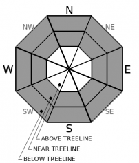
Loose wet avalanches will be possible today on all aspects in near and below treeline terrain.  As daytime warming occurs along with rain at lower elevations, loose wet avalanches involving the recent storm snow are expected.  Most of these loose wet instabilities will be small in size and in the form of roller balls and pinwheels, but some could become larger and involve older wet snow. 

Wet and unsupportable snow will be capable of loose wet avalanches today.  Use terrain to help limit exposure and avoid overhead hazards.

recent observations

*  Warm and wet conditions were reported from Rubicon Peak (West Shore area) yesterday.  Cloudy skies overnight, above freezing temperatures, and light rain provided no refreeze of the snowpack with wet surface snow from the trailhead to the peak top.  Avalanche instabilities were limited to small roller ball activity into the midday.

Weather and CURRENT CONDITIONS
weather summary

Snow levels topped out at over 9000' yesterday afternoon before lowering through the night down to around 7000'.  1 to 4'' of wet heavy snow has fallen along the Sierra Crest overnight above 8000' with about 2'' in the Mt. Rose area.  3 to 6'' of additional snow is forecasted for today along the Sierra Crest with around 3'' in the Carson Range.  A brief weather break is expected on Wednesday before unsettled weather returns through the weekend.

CONDITIONS ALONG THE SIERRA CREST BETWEEN 8200 FT. AND 9200 FT. IN THE LAST 24 HOURS
6am temperature: 28 to 34 deg. F.
Max. temperature: 37 to 49 deg. F.
Average ridgetop wind direction: SW
Average ridgetop wind speed: 20 to 35 mph
Maximum ridgetop wind gust: 49 mph
New snowfall: 1 to 4 inches
Total snow depth: 112 to 160 inches
Two-Day Mountain Weather Forecast Produced in partnership with the Reno NWS
For 7000 ft. to 8000 ft.
Tuesday Tuesday Night Wednesday
Weather: Cloudy. Snow and rain in the morning, then widespread showers and isolated thunderstorms possible in the afternoon. Snow levels 7000 feet. Chance of precipitation is 85%. Mostly cloudy. Scattered showers in the evening, then slight chance of snow showers after midnight. Snow levels below 7000 feet. Chance of precipitation is 50%. Partly cloudy. Snow levels below 7000 feet increasing to 7000 feet in the afternoon. Chance of precipitation is 5%.
Temperatures: 39 to 45. deg. F. 24 to 29. deg. F. 43 to 49. deg. F.
Mid Slope Winds: Southwest 15 to 25 mph. Gusts up to 35 mph. Southwest 10 to 20 mph. Gusts up to 30 mph. Southwest 10 to 15 mph.
Expected snowfall: 60% probability of 1 to 2 inches. 40% probability of no accumulation. | SWE = 0.15-0.40 inch. 60% probability of 1 to 2 inches. 40% probability of no accumulation. | SWE = less than 0.10 inch. No accumulation. | SWE = none.
For 8000 ft. to 9000 ft.
Tuesday Tuesday Night Wednesday
Weather: Cloudy. Snow in the morning, then widespread snow showers and isolated thunderstorms possible in the afternoon. Snow levels 7000 feet. Chance of precipitation is 85%. Mostly cloudy. Scattered snow showers in the evening, then slight chance of snow showers after midnight. Snow levels below 7000 feet. Chance of precipitation is 55%. Partly cloudy. Snow levels below 7000 feet increasing to 7000 feet in the afternoon. Chance of precipitation is 5%.
Temperatures: 35 to 41. deg. F. 21 to 26. deg. F. 39 to 45. deg. F.
Ridge Top Winds: Southwest 20 to 35 mph with gusts to 60 mph. Southwest 15 to 30 mph with gusts to 50 mph. Southwest 15 to 20 mph. Gusts up to 45 mph decreasing to 30 mph in the afternoon.
Expected snowfall: 80% probability of 2 to 5 inches. 20% probability of 4 to 7 inches. | SWE = 0.20-0.45 inch. 80% probability up to 2 inches. 20% probability of 2 to 4 inches. | SWE = up to 0.15 inch. No accumulation. | SWE = none.
Disclaimer

This avalanche forecast is provided through a partnership between the Tahoe National Forest and the Sierra Avalanche Center. This forecast covers the Central Sierra Nevada Mountains between Yuba Pass on the north and Ebbetts Pass on the south. Click here for a map of the forecast area. This forecast applies only to backcountry areas outside established ski area boundaries. This forecast describes general avalanche conditions and local variations always occur. This forecast expires 24 hours after the posted time unless otherwise noted. The information in this forecast is provided by the USDA Forest Service who is solely responsible for its content.

For a recorded version of the avalanche forecast call (530) 587-3558 x258