THIS AVALANCHE FORECAST EXPIRED ON April 6, 2019 @ 6:57 am
Avalanche Forecast published on April 5, 2019 @ 6:57 am
Issued by Andy Anderson - Tahoe National Forest - Sierra Avalanche Center

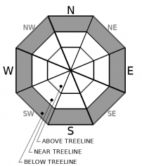
The avalanche danger should remain LOW for near and above treeline areas since wind slab formation should remain limited due to meager snowfall amounts. Below treeline potential rain on snow and warmer temperatures will keep the avalanche danger at MODERATE since loose wet avalanches may be possible.

1. Low

?

Above Treeline
Generally safe avalanche conditions. Watch for unstable snow on isolated terrain features.

1. Low

?

Near Treeline
Generally safe avalanche conditions. Watch for unstable snow on isolated terrain features.

2. Moderate

?

Below Treeline
Heightened avalanche conditions on specific terrain features. Evaluate snow and terrain carefully; identify features of concern.
    Heightened avalanche conditions on specific terrain features. Evaluate snow and terrain carefully; identify features of concern.
Avalanche Problem 1: Loose Wet
  • Type ?
  • Aspect/Elevation ?
  • Likelihood ?
    Certain
    Very Likely
    Likely
    Possible
    Unlikely
  • Size ?
    Historic
    Very Large
    Large
    Small

Cooler daytime temperatures and a better overnight refreeze above 7500 ft. should keep most loose wet instabilities at bay today. However, some loose wet activity may be possible at the lower elevations especially if rain falls on snow. Some of these could still entrain enough snow to cause problems for backcountry travelers.

If the snow becomes unsupportable and wet, it is time to reconsider the terrain and move an area/elevation where colder more frozen conditions still exist.  

Avalanche Problem 2: Wind Slab
  • Type ?
  • Aspect/Elevation ?
  • Likelihood ?
    Certain
    Very Likely
    Likely
    Possible
    Unlikely
  • Size ?
    Historic
    Very Large
    Large
    Small

Up to 1 inch of snow last night and 1 to 3 inches of snow this afternoon should not provide enough new snow for significant wind slabs to form despite strong SW winds. Some small shallow wind slabs may develop along a few exposed ridgelines. They would be unlikely to cause problems for backcountry travelers unless travelers choose to travel in terrain where just getting knocked off balance would have serious consequences. If more snow falls than forecasted, larger more problematic wind slabs could form.

recent observations

* Wet snow was observed on all aspects up to 9000 ft. in the Genoa Peak area and up to 7800 ft in Johnson Canyon yesterday. Some roller balls were spotted on E facing slopes in Johnson Canyon. 

* Snowmobile slope cuts on previously wind-loaded test slopes on Genoa Peak did not produce signs of lingering wind slab instability even when the slope was undercut. Snowpit tests in this area also did not yield unstable results.

Weather and CURRENT CONDITIONS
weather summary

Another weak spring storm should push through the region today and tomorrow. Snow levels should remain between 6000 and 7000 ft. Snow showers should pick up this afternoon with about 3 inches of snow forecasted by the end of today above 7000 ft. Snow showers should decrease in intensity through the night and tomorrow. By Sunday clear sunny weather should make an appearance over the forecast area.

CONDITIONS ALONG THE SIERRA CREST BETWEEN 8200 FT. AND 9200 FT. IN THE LAST 24 HOURS
6am temperature: 25 to 30 deg. F.
Max. temperature: 32 to 42 deg. F.
Average ridgetop wind direction: SW
Average ridgetop wind speed: 30 to 35 mph
Maximum ridgetop wind gust: 61 mph
New snowfall: up to 1 inches
Total snow depth: 112 to 159 inches
Two-Day Mountain Weather Forecast Produced in partnership with the Reno NWS
For 7000 ft. to 8000 ft.
Friday Friday Night Saturday
Weather: Mostly cloudy. Isolated snow showers in the morning, then widespread snow showers in the afternoon. Snow levels below 7000 feet. Chance of precipitation is 90%. Mostly cloudy then becoming partly cloudy. Scattered snow showers. Snow levels below 7000 feet. Chance of precipitation is 45%. Mostly cloudy. Scattered showers. Snow levels below 7000 feet increasing to 7000 feet in the afternoon. Chance of precipitation is 30%.
Temperatures: 34 to 40 deg. F. 23 to 28 deg. F. 40 to 46 deg. F.
Mid Slope Winds: Southwest 15 to 25 mph. Gusts to 40 mph. Southwest 10 to 20 mph. Gusts up to 40 mph decreasing to 30 mph after midnight. Southwest 10 to 20 mph with gusts to 30 mph.
Expected snowfall: 70% probability of 1 to 3 inches. 30% probability of 3 to 6 inches. | SWE = up to 0.40 inch. 70% probability up to 1 inch. 30% probability of 1 to 2 inches. | SWE = less than 0.10 inch. 60% probability up to 1 inch. 40% probability of 1 to 3 inches. | SWE = less than 0.25 inch.
For 8000 ft. to 9000 ft.
Friday Friday Night Saturday
Weather: Mostly cloudy. Isolated snow showers in the morning, then widespread snow showers in the afternoon. Snow levels below 7000 feet. Chance of precipitation is 100%. Mostly cloudy then becoming partly cloudy. Scattered snow showers in the evening. Snow levels below 7000 feet. Chance of precipitation is 50%. Mostly cloudy. Scattered snow showers. Snow levels below 7000 feet increasing to 7000 feet in the afternoon. Chance of precipitation is 40%.
Temperatures: 28 to 34 deg. F. 20 to 25 deg. F. 33 to 38 deg. F.
Ridge Top Winds: Southwest 25 to 45 mph with gusts to 65 mph. Southwest 15 to 30 mph with gusts to 50 mph. Southwest 15 to 25 mph with gusts to 40 mph.
Expected snowfall: 70% probability of 1 to 3 inches. 30% probability of 3 to 6 inches. | SWE = up to 0.40 inch. 70% probability up to 1 inch. 30% probability of 1 to 2 inches. | SWE = less than 0.10 inch. 60% probability up to 1 inch. 40% probability of 1 to 3 inches. | SWE = less than 0.25 inch.
Disclaimer

This avalanche forecast is provided through a partnership between the Tahoe National Forest and the Sierra Avalanche Center. This forecast covers the Central Sierra Nevada Mountains between Yuba Pass on the north and Ebbetts Pass on the south. Click here for a map of the forecast area. This forecast applies only to backcountry areas outside established ski area boundaries. This forecast describes general avalanche conditions and local variations always occur. This forecast expires 24 hours after the posted time unless otherwise noted. The information in this forecast is provided by the USDA Forest Service who is solely responsible for its content.

For a recorded version of the avalanche forecast call (530) 587-3558 x258