THIS AVALANCHE FORECAST EXPIRED ON April 8, 2019 @ 6:45 am
Avalanche Forecast published on April 7, 2019 @ 6:45 am
Issued by Brandon Schwartz - Tahoe National Forest

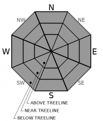
MODERATE avalanche danger is expected today at all elevations due to a combination of loose wet avalanches and lingering wind slabs. Anticipate increasing avalanche concerns due to warming as the day progresses.

2. Moderate

?

Above Treeline
Heightened avalanche conditions on specific terrain features. Evaluate snow and terrain carefully; identify features of concern.

2. Moderate

?

Near Treeline
Heightened avalanche conditions on specific terrain features. Evaluate snow and terrain carefully; identify features of concern.

2. Moderate

?

Below Treeline
Heightened avalanche conditions on specific terrain features. Evaluate snow and terrain carefully; identify features of concern.
    Heightened avalanche conditions on specific terrain features. Evaluate snow and terrain carefully; identify features of concern.
Avalanche Problem 1: Loose Wet
  • Type ?
  • Aspect/Elevation ?
  • Likelihood ?
    Certain
    Very Likely
    Likely
    Possible
    Unlikely
  • Size ?
    Historic
    Very Large
    Large
    Small

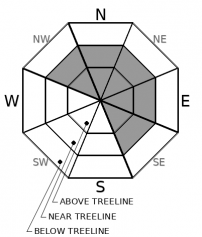
Last night, cloud cover and SW winds kept air temperatures above freezing in most areas below about 8,000' to 8,200'. As cloud cover thins today, air temperatures will warm quickly at all elevations. The shallow recent new snow will be prone to loose wet avalanche activity today on all aspects. SW ridgetop winds may provide some convective cooling near the ridgetops with snow surface melt occurring more rapidly just a short distance downslope. Avalanche size is expected mostly at D1 with up to size D2 possible.

It is getting later in the season and the sun angle is fairly high. It is becoming increasingly challenging to use aspect to avoid snow surface warming so slope angle is the go to strategy for reducing loose wet avalanche hazard. Pay attention to snow surface warming and the presence of rollerballs and pinwheels. Once these start to form, move to lower angle terrain. Pre plan route options that give a choice of slope angle.

Avalanche Problem 2: Wind Slab
  • Type ?
  • Aspect/Elevation ?
  • Likelihood ?
    Certain
    Very Likely
    Likely
    Possible
    Unlikely
  • Size ?
    Historic
    Very Large
    Large
    Small

Recent new snow and SW winds have created wind slabs up to a foot or so thick in near treeline and above treeline areas on NW-N-NE-E-SE aspects. These wind slabs may remain unstable today and could be made easier to trigger by rapid warming. Wind slabs could take on wet slab characteristics in some areas. Anticipate avalanche size at D1 to D2.

Identify where wind slabs exist in avalanche terrain by looking for signs of drifted snow in the form of wind pillows, textured snow surfaces, and areas below cornices. Once the features of concern are identified, find routes around them that minimize the hazard.

recent observations

* The presence of unstable wind slabs up to 1 foot thick were reported yesterday from near to above treeline areas on N-NE-E aspects on Andesite Peak (Donner Summit area) and on Waterhouse Peak (Luther Pass area). Difficulty of triggering ranged from reactive to stubborn.

* Poorly refrozen wet snow was noted below the crust at the bottom of the recent storm snow up to at least 8,100' in the Donner Summit area yesterday.

* New snow amounts from Friday/Saturday range from 1 to 5 inches with the greatest accumulations above 7,000' along the Sierra Crest.

Weather and CURRENT CONDITIONS
weather summary

Weak and short lived high pressure will push storm systems to the north of the forecast area today. Chances of rain and snow return to the forecast area Monday afternoon and continue through this week. Decreasing cloud cover today and well above freezing air temperatures will bring some warming that will last into tomorrow. Moderate to strong SW ridgetop winds continue today and tomorrow. A cold front is expected to pass through the region early Tuesday morning with colder air temperatures lasting through most of this week.

CONDITIONS ALONG THE SIERRA CREST BETWEEN 8200 FT. AND 9200 FT. IN THE LAST 24 HOURS
6am temperature: 31 to 34 deg. F.
Max. temperature: 32 to 38 deg. F.
Average ridgetop wind direction: SW
Average ridgetop wind speed: 52 mph
Maximum ridgetop wind gust: 87 mph
New snowfall: Trace to 1 inches
Total snow depth: 112 to 160 inches
Two-Day Mountain Weather Forecast Produced in partnership with the Reno NWS
For 7000 ft. to 8000 ft.
Sunday Sunday Night Monday
Weather: Mostly cloudy then becoming partly cloudy. Snow levels 7500 feet increasing to 8500 feet in the afternoon. Chance of precipitation is 0%. Mostly cloudy. Snow levels 8500 to 9000 feet. Chance of precipitation is 0%. Partly cloudy becoming mostly cloudy. Chance of rain in the afternoon. Snow levels 9000 to 9500 feet. Chance of precipitation is 30%.
Temperatures: 49 to 55 deg. F. 31 to 36 deg. F. 49 to 55 deg. F.
Mid Slope Winds: Southwest 15 to 25 mph. Gusts up to 40 mph. Southwest 15 to 25 mph with gusts to 45 mph. Southwest 15 to 20 mph with gusts to 40 mph increasing to 20 to 30 mph with gusts to 50 mph in the afternoon.
Expected snowfall: No accumulation. | SWE = none. No accumulation. | SWE = none. No accumulation. | SWE = less than 0.10 inch.
For 8000 ft. to 9000 ft.
Sunday Sunday Night Monday
Weather: Mostly cloudy then becoming partly cloudy. Snow levels 7500 feet increasing to 8500 feet in the afternoon. Chance of precipitation is 0%. Mostly cloudy. Snow levels 8500 to 9000 feet. Chance of precipitation is 0%. Partly cloudy then becoming mostly cloudy. Chance of rain in the afternoon. Snow levels 9000 to 9500 feet. Chance of precipitation is 40%.
Temperatures: 40 to 48 deg. F. 29 to 34 deg. F. 42 to 50 deg. F.
Ridge Top Winds: Southwest 25 to 45 mph with gusts to 65 mph. Southwest 20 to 35 mph. Gusts up to 55 mph decreasing to 45 mph after midnight. Southwest 25 to 45 mph with gusts to 65 mph.
Expected snowfall: No accumulation. | SWE = none. No accumulation. | SWE = none. No accumulation. | SWE = less than 0.10 inch.
Disclaimer

This avalanche forecast is provided through a partnership between the Tahoe National Forest and the Sierra Avalanche Center. This forecast covers the Central Sierra Nevada Mountains between Yuba Pass on the north and Ebbetts Pass on the south. Click here for a map of the forecast area. This forecast applies only to backcountry areas outside established ski area boundaries. This forecast describes general avalanche conditions and local variations always occur. This forecast expires 24 hours after the posted time unless otherwise noted. The information in this forecast is provided by the USDA Forest Service who is solely responsible for its content.

For a recorded version of the avalanche forecast call (530) 587-3558 x258