THIS AVALANCHE FORECAST EXPIRED ON December 16, 2019 @ 6:56 am
Avalanche Forecast published on December 15, 2019 @ 6:56 am
Issued by Andy Anderson - Tahoe National Forest - Sierra Avalanche Center

MODERATE avalanche danger will exist in near and above treeline terrain today due to the presence of both new and old wind slabs. Human-triggered avalanches remain possible on steep slopes where slabs of wind drifted snow have formed. Avalanche activity is unlikely in sheltered, below treeline terrain (LOW avalanche danger).

2. Moderate

?

Above Treeline
Heightened avalanche conditions on specific terrain features. Evaluate snow and terrain carefully; identify features of concern.

2. Moderate

?

Near Treeline
Heightened avalanche conditions on specific terrain features. Evaluate snow and terrain carefully; identify features of concern.

1. Low

?

Below Treeline
Generally safe avalanche conditions. Watch for unstable snow on isolated terrain features.
    Heightened avalanche conditions on specific terrain features. Evaluate snow and terrain carefully; identify features of concern.
Avalanche Problem 1: Wind Slab
  • Type ?
  • Aspect/Elevation ?
  • Likelihood ?
    Certain
    Very Likely
    Likely
    Possible
    Unlikely
  • Size ?
    Historic
    Very Large
    Large
    Small

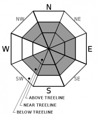
Strong winds during the night combined with some new snow have formed fresh drifts of snow in wind-exposed near and above treeline terrain. The new slabs of wind drifted snow may be sensitive to human triggers today. Older wind slabs may also still linger in some places especially in complex or extreme terrain. Wind slab avalanches could involve enough snow to bury or injure a person (D2). While the largest wind slabs should exist on N-NE-E aspects, SW and W winds during the night and NW winds this afternoon mean that wind slabs could exist on almost any aspect. Large fragile cornices may also lurk above wind-loaded slopes.

Identifying where wind slabs may exist by using clues like blowing snow, cornices above a slope, drifted snow, and other wind created features can help create safety margins to reduce exposure to avalanche problems. This information can also help tailor travel plans to find better quality snow on more sheltered slopes.

recent observations

* Yesterday observations from Hidden Peak on the West Shore found some stubborn, hard, wind slabs on leeward slopes near the summit. Ski cuts/kicks on wind-loaded test slopes and snowpit tests did not reveal any signs of instability.

* In more sheltered areas on Hidden Peak, observations showed a well-bonded snowpack with the recent snow resting on top of a supportable rain crust. Below 7000 ft. coverage remains poor. 

* Observations from 2 days ago in the Mt. Rose area and on Carson Pass found fragile cornices and signs of growing wind slabs

Weather and CURRENT CONDITIONS
weather summary

After another burst of snow and strong west and southwest winds last night, the storm has started to depart. The winds should start to decrease and shift to the west and northwest today. The forecast calls for the ridgetop winds to increase some and shift to the northeast tonight. A high-pressure ridge building over the area should bring clearing skies and sunshine through Tuesday.

CONDITIONS ALONG THE SIERRA CREST BETWEEN 8200 FT. AND 9200 FT. IN THE LAST 24 HOURS
6am temperature: 10 to 17 deg. F.
Max. temperature: 20 to 30 deg. F.
Average ridgetop wind direction: Southwest and west
Average ridgetop wind speed: 25 to 37 mph
Maximum ridgetop wind gust: 79 mph
New snowfall: 3 to 7 inches
Total snow depth: 51 to 60 inches
Two-Day Mountain Weather Forecast Produced in partnership with the Reno NWS
For 7000 ft. to 8000 ft.
Sunday Sunday Night Monday
Weather: Partly cloudy then becoming sunny. Snow levels below 7000 feet. Chance of precipitation is 5%. Clear. Snow levels below 7000 feet. Chance of precipitation is 0%. Sunny. Snow levels below 7000 feet. Chance of precipitation is 0%.
Temperatures: 25 to 30 deg. F. 11 to 17 deg. F. 27 to 32 deg. F.
Mid Slope Winds: West to northwest around 10 mph. Light winds. Light winds.
Expected snowfall: No accumulation. | SWE = none. No accumulation. | SWE = none. No accumulation. | SWE = none.
For 8000 ft. to 9000 ft.
Sunday Sunday Night Monday
Weather: Partly cloudy then becoming sunny. Snow levels below 7000 feet. Chance of precipitation is 5%. Clear. Snow levels below 7000 feet. Chance of precipitation is 0%. Sunny. Snow levels below 7000 feet. Chance of precipitation is 0%.
Temperatures: 21 to 27 deg. F. 9 to 15 deg. F. 23 to 28 deg. F.
Ridge Top Winds: West to northwest 20 to 35 mph with gusts to 50 mph in the morning decreasing to northwest 15 to 25 mph. Northeast to east 15 to 20 mph with gusts to 35 mph. East around 15 mph with gusts to 30 mph.
Expected snowfall: No accumulation. | SWE = none. No accumulation. | SWE = none. No accumulation. | SWE = none.
Disclaimer

This avalanche forecast is provided through a partnership between the Tahoe National Forest and the Sierra Avalanche Center. This forecast covers the Central Sierra Nevada Mountains between Yuba Pass on the north and Ebbetts Pass on the south. Click here for a map of the forecast area. This forecast applies only to backcountry areas outside established ski area boundaries. This forecast describes general avalanche conditions and local variations always occur. This forecast expires 24 hours after the posted time unless otherwise noted. The information in this forecast is provided by the USDA Forest Service who is solely responsible for its content.

For a recorded version of the avalanche forecast call (530) 587-3558 x258