THIS AVALANCHE FORECAST EXPIRED ON December 17, 2019 @ 6:55 am
Avalanche Forecast published on December 16, 2019 @ 6:55 am
Issued by Steve Reynaud - Tahoe National Forest

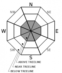
MODERATE avalanche danger will continue in above treeline terrain due to wind slabsLOW avalanche danger will exist in near and below treeline terrain.

2. Moderate

?

Above Treeline
Heightened avalanche conditions on specific terrain features. Evaluate snow and terrain carefully; identify features of concern.

1. Low

?

Near Treeline
Generally safe avalanche conditions. Watch for unstable snow on isolated terrain features.

1. Low

?

Below Treeline
Generally safe avalanche conditions. Watch for unstable snow on isolated terrain features.
    Heightened avalanche conditions on specific terrain features. Evaluate snow and terrain carefully; identify features of concern.
Avalanche Problem 1: Wind Slab
  • Type ?
  • Aspect/Elevation ?
  • Likelihood ?
    Certain
    Very Likely
    Likely
    Possible
    Unlikely
  • Size ?
    Historic
    Very Large
    Large
    Small

Lingering wind slabs and newly forming wind slabs could exist in above treeline terrain on most aspects due to recent shifts in wind directions.  Yesterday, winds shifted to the NE and increased in speed to the moderate to strong range overnight.  With snow available for transport, these winds will transport snow in above treeline terrain to form wind slabs on S-SW-W aspects.  Snow transport is expected to be limited to the higher elevations and the most exposed terrain due to the forecasted NE wind speeds.

Look for blowing snow, new cornice formation, and wind pillows.  Large fragile cornices may still exist along ridgelines that have been built out during the last storm system.  These NE winds may further scour exposed areas down to previous firm rain crusts.

recent observations

* Wind scouring and newly formed wind slabs were seen throughout the forecast region.  Fragile cornices and reactive wind slabs on test slopes were reported in some areas, with other areas reporting limited signs of instabilities.

* A large and accidental cornice failure occurred in the Ward Canyon area yesterday.  The cornice failure was on a SE/E aspect and triggered 6 feet away.

* Firm rain crusts have been exposed by recent wind scouring.  On Red Lake Peak (Carson Pass area) rain crusts were observed up to at least 9500'


Weather and CURRENT CONDITIONS
weather summary

A sunny and cold day is forecasted for our area with NE/E winds in the moderate to strong range at the higher elevations.  Increasing clouds and winds are expected by Tuesday afternoon as a minor storm approaches our area.  Light snow is possible on Wednesday.  Another break is expected before a potential storm later in the week. 

CONDITIONS ALONG THE SIERRA CREST BETWEEN 8200 FT. AND 9200 FT. IN THE LAST 24 HOURS
6am temperature: 9 to 20 deg. F.
Max. temperature: 27 deg. F.
Average ridgetop wind direction: SW to NE
Average ridgetop wind speed: 15 to 35 mph
Maximum ridgetop wind gust: 46 mph
New snowfall: 0 inches
Total snow depth: 49 to 55 inches
Two-Day Mountain Weather Forecast Produced in partnership with the Reno NWS
For 7000 ft. to 8000 ft.
Monday Monday Night Tuesday
Weather: Partly cloudy then becoming sunny. Snow levels below 7000 feet. Chance of precipitation is 0%. Clear then becoming partly cloudy. Snow levels below 7000 feet. Chance of precipitation is 0%. Mostly cloudy. Snow levels below 7000 feet. Chance of precipitation is 0%.
Temperatures: 27 to 32. deg. F. 14 to 20. deg. F. 32 to 37. deg. F.
Mid Slope Winds: Northeast to east up to 10 mph. Light winds. Southeast up to 10 mph.
Expected snowfall: No accumulation. | SWE = none. No accumulation. | SWE = none. No accumulation. | SWE = none.
For 8000 ft. to 9000 ft.
Monday Monday Night Tuesday
Weather: Partly cloudy then becoming sunny. Snow levels below 7000 feet. Chance of precipitation is 0%. Clear then becoming partly cloudy. Snow levels below 7000 feet. Chance of precipitation is 0%. Mostly cloudy. Snow levels below 7000 feet. Chance of precipitation is 0%.
Temperatures: 24 to 29. deg. F. 16 to 21. deg. F. 29 to 34. deg. F.
Ridge Top Winds: East 15 to 25 mph. Gusts up to 40 mph in the morning. East to southeast around 15 mph with gusts to 25 mph. South around 15 mph with gusts to 35 mph increasing to southeast 20 to 30 mph with gusts to 50 mph in the afternoon.
Expected snowfall: No accumulation. | SWE = none. No accumulation. | SWE = none. No accumulation. | SWE = none.
Disclaimer

This avalanche forecast is provided through a partnership between the Tahoe National Forest and the Sierra Avalanche Center. This forecast covers the Central Sierra Nevada Mountains between Yuba Pass on the north and Ebbetts Pass on the south. Click here for a map of the forecast area. This forecast applies only to backcountry areas outside established ski area boundaries. This forecast describes general avalanche conditions and local variations always occur. This forecast expires 24 hours after the posted time unless otherwise noted. The information in this forecast is provided by the USDA Forest Service who is solely responsible for its content.

For a recorded version of the avalanche forecast call (530) 587-3558 x258