THIS AVALANCHE FORECAST EXPIRED ON December 18, 2019 @ 6:50 am
Avalanche Forecast published on December 17, 2019 @ 6:50 am
Issued by Steve Reynaud - Tahoe National Forest

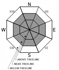
Increasing and shifting winds will keep the avalanche danger at MODERATE today due to wind slabs in near and above treeline terrain.  LOW avalanche danger will continue in below treeline areas.

2. Moderate

?

Above Treeline
Heightened avalanche conditions on specific terrain features. Evaluate snow and terrain carefully; identify features of concern.

2. Moderate

?

Near Treeline
Heightened avalanche conditions on specific terrain features. Evaluate snow and terrain carefully; identify features of concern.

1. Low

?

Below Treeline
Generally safe avalanche conditions. Watch for unstable snow on isolated terrain features.
    Heightened avalanche conditions on specific terrain features. Evaluate snow and terrain carefully; identify features of concern.
Avalanche Problem 1: Wind Slab
  • Type ?
  • Aspect/Elevation ?
  • Likelihood ?
    Certain
    Very Likely
    Likely
    Possible
    Unlikely
  • Size ?
    Historic
    Very Large
    Large
    Small

Strong winds have been blowing over the last 2 days from multiple directions.  Yesterday's NE/E winds transported snow in upper elevation areas and scoured wind exposed terrain.  Winds have shifted overnight to the S and are forecasted to be strong by this afternoon.  Wind slabs will be possible on all aspects in near and above treeline terrain.  Wind slabs could have soft or hard slab characteristics.

Blowing snow, new cornice formation, and snow surface scouring will be clues to where new wind slabs are forming.  Complex terrain may have wind slabs mixed with areas of wind scoured crusts.  Firm exposed rain crusts along ridges could cause travel concerns.

recent observations

* A small skier triggered wind slab avalanche occurred on Cinder Cone (Ward Canyon area) yesterday.  The area was on a N/NE aspect in near treeline terrain.  The slide ran full slope.  The skier was able to get off to the side of the slide and was not injured.

* Strong NE winds with intense wind loading was reported from the Ward Canyon area and Carson Pass area.  Other locations experienced lighter winds with less wind transport.

* Snow surface conditions above treeline vary from scoured firm rain crust, dense hard wind slabs, and a variety of different wind textured surfaces.  In below treeline terrain, cold dry snow exists on most northerly aspects.  

Weather and CURRENT CONDITIONS
weather summary

Clouds and wind will be on the increase today ahead of a low pressure system moving towards our area tonight and into Wednesday.  Inversions are in place with colder temperatures in valley locations and warmer air at the higher elevations.  Up to 2'' of snowfall is expected for Wednesday.  A warming trend and break will start on Thursday and go into the first part of the weekend.  Then another storm is possible for Saturday evening into Sunday. 

CONDITIONS ALONG THE SIERRA CREST BETWEEN 8200 FT. AND 9200 FT. IN THE LAST 24 HOURS
6am temperature: 20 to 35 deg. F.
Max. temperature: 35 deg. F.
Average ridgetop wind direction: NE shifting to S
Average ridgetop wind speed: 20 to 50 mph
Maximum ridgetop wind gust: 73 mph
New snowfall: 0 inches
Total snow depth: 47 to 54 inches
Two-Day Mountain Weather Forecast Produced in partnership with the Reno NWS
For 7000 ft. to 8000 ft.
Tuesday Tuesday Night Wednesday
Weather: Mostly cloudy. Snow levels below 7000 feet. Chance of precipitation is 0%. Mostly cloudy. Snow levels below 7000 feet. Chance of precipitation is 5%. Mostly cloudy. Chance of snow. Snow levels below 7000 feet. Chance of precipitation is 50%.
Temperatures: 32 to 37. deg. F. 19 to 24. deg. F. 28 to 33. deg. F.
Mid Slope Winds: South to southeast up to 10 mph. South around 10 mph. Southwest around 15 mph with gusts to 30 mph.
Expected snowfall: No accumulation. | SWE = none. No accumulation. | SWE = none. up to 2 inches. | SWE = less than 0.20 inch.
For 8000 ft. to 9000 ft.
Tuesday Tuesday Night Wednesday
Weather: Mostly cloudy. Snow levels below 7000 feet. Chance of precipitation is 0%. Mostly cloudy. Snow levels below 7000 feet. Chance of precipitation is 5%. Mostly cloudy. Snow likely. Snow levels below 7000 feet. Chance of precipitation is 60%.
Temperatures: 29 to 34. deg. F. 14 to 19. deg. F. 23 to 28. deg. F.
Ridge Top Winds: Southeast to south 10 to 15 mph increasing to south 15 to 25 mph with gusts up to 45 mph in the afternoon. South 20 to 30 mph with gusts to 65 mph. Southwest 20 to 30 mph with gusts to 60 mph.
Expected snowfall: No accumulation. | SWE = none. No accumulation. | SWE = none. up to 2 inches. | SWE = less than 0.20 inch.
Disclaimer

This avalanche forecast is provided through a partnership between the Tahoe National Forest and the Sierra Avalanche Center. This forecast covers the Central Sierra Nevada Mountains between Yuba Pass on the north and Ebbetts Pass on the south. Click here for a map of the forecast area. This forecast applies only to backcountry areas outside established ski area boundaries. This forecast describes general avalanche conditions and local variations always occur. This forecast expires 24 hours after the posted time unless otherwise noted. The information in this forecast is provided by the USDA Forest Service who is solely responsible for its content.

For a recorded version of the avalanche forecast call (530) 587-3558 x258