THIS AVALANCHE FORECAST EXPIRED ON December 3, 2019 @ 6:52 am
Avalanche Forecast published on December 2, 2019 @ 6:52 am
Issued by Steve Reynaud - Tahoe National Forest

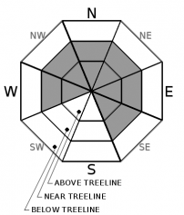
A mixture of warm temperatures, upper elevation snow, and rain will keep the avalanche danger elevated today.  CONSIDERABLE avalanche danger will exist in near and above treeline areas due to wind slabs.  Below treeline areas will have MODERATE avalanche danger due to storm slabs and loose wet avalanches.  Dangerous avalanche conditions exist.

3. Considerable

?

Above Treeline
Dangerous avalanche conditions. Careful snowpack evaluation, cautious route-finding and conservative decision-making essential.

3. Considerable

?

Near Treeline
Dangerous avalanche conditions. Careful snowpack evaluation, cautious route-finding and conservative decision-making essential.

2. Moderate

?

Below Treeline
Heightened avalanche conditions on specific terrain features. Evaluate snow and terrain carefully; identify features of concern.
    Dangerous avalanche conditions. Careful snowpack evaluation, cautious route-finding and conservative decision-making essential.
Avalanche Problem 1: Wind Slab
  • Type ?
  • Aspect/Elevation ?
  • Likelihood ?
    Certain
    Very Likely
    Likely
    Possible
    Unlikely
  • Size ?
    Historic
    Very Large
    Large
    Small

Strong S/SW winds will continue to build wind slabs in near and above treeline terrain today.  Warming temperatures with additional heavy snow will further overload these wind slabs with the previous lighter snow underneath.  Wind slab avalanches could be naturally or human triggered and could be large and destructive in size.  Look for signs of current and previous wind loading including: blowing snow, cornice formation, wind pillows, and snow surface scouring.  Make a plan to avoid wind loaded terrain and areas below large cornices

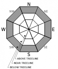
Avalanche Problem 2: Storm Slab
  • Type ?
  • Aspect/Elevation ?
  • Likelihood ?
    Certain
    Very Likely
    Likely
    Possible
    Unlikely
  • Size ?
    Historic
    Very Large
    Large
    Small

Storm slabs will be possible on all aspects in wind protected below treeline areas as the storm continues.  Warming temperatures today will lead to an upside down snowpack with heavier snow on top of lighter snow.  In addition, rising snow levels throughout the day could cause storm slabs to fail with rain on new snow.  These storm slabs could be dry or wet depending on elevation and location.  Snow level is forecasted to rise to 7500' today.   

Avalanche Problem 3: Loose Wet
  • Type ?
  • Aspect/Elevation ?
  • Likelihood ?
    Certain
    Very Likely
    Likely
    Possible
    Unlikely
  • Size ?
    Historic
    Very Large
    Large
    Small

Loose wet avalanches will be likely at lower elevations that saw snow overnight and transitioned to rain today.  Most of these loose wet avalanches should be small in size and in the form of roller balls.  Snow coverage at lower elevations remains thin and extra caution should be used to avoid all the obstacles that are hiding under the recent snow.

recent observations

* Snow levels reported close to 7500' yesterday along the Sierra Crest.

* Cracking, a collapse, and multiple unstable snowpack test results submitted.

Weather and CURRENT CONDITIONS
weather summary

Snow and rain will continue with moderate to heavy snow expected above 7000' through tonight.  Snow levels are expected to rise to around 7500' today.  Strong to gale force S/SW winds will continue this morning before decreasing this afternoon.  Unsettled weather continues through the week.

CONDITIONS ALONG THE SIERRA CREST BETWEEN 8200 FT. AND 9200 FT. IN THE LAST 24 HOURS
6am temperature: 28 to 33 deg. F.
Max. temperature: 34 deg. F.
Average ridgetop wind direction: SW
Average ridgetop wind speed: 35 to 60 mph
Maximum ridgetop wind gust: 107 mph
New snowfall: 11 to 23 inches
Total snow depth: 31 to 54 inches
Two-Day Mountain Weather Forecast Produced in partnership with the Reno NWS
For 7000 ft. to 8000 ft.
Monday Monday Night Tuesday
Weather: Cloudy. Snow and rain in the morning, then rain and snow likely in the afternoon. Snow levels 7500 feet. Chance of precipitation is 95%. Cloudy. Chance of rain and snow. Snow levels 7500 feet. Chance of precipitation is 40%. Mostly cloudy. Slight chance of rain and snow. Snow levels 7000 feet. Chance of precipitation is 20%.
Temperatures: 33 to 38. deg. F. 26 to 32. deg. F. 32 to 37. deg. F.
Mid Slope Winds: South around 15 mph. Gusts up to 35 mph decreasing to 25 mph in the afternoon. Light winds. Light winds.
Expected snowfall: 70% probability of 1 to 5 inches. 30% probability up to 1 inch. | SWE = 0.25-0.50 inch. 80% probability up to 1 inch. 20% probability of 1 to 3 inches. | SWE = up to 0.15 inch. No accumulation. | SWE = less than 0.10 inch.
For 8000 ft. to 9000 ft.
Monday Monday Night Tuesday
Weather: Cloudy. Snow in the morning, then snow and rain likely in the afternoon. Snow levels 7500 feet. Chance of precipitation is 95%. Mostly cloudy. Chance of snow. Snow levels 7500 feet. Chance of precipitation is 40%. Mostly cloudy. Slight chance of snow. Snow levels 7000 feet. Chance of precipitation is 20%.
Temperatures: 30 to 35. deg. F. 23 to 28. deg. F. 29 to 34. deg. F.
Ridge Top Winds: South 25 to 35 mph with gusts to 60 mph decreasing to 15 to 25 mph with gusts to 35 mph in the afternoon. South 15 to 20 mph with gusts to 30 mph. South around 15 mph with gusts to 25 mph.
Expected snowfall: 70% probability of 2 to 6 inches. 30% probability up to 2 inches. | SWE = 0.30-0.55 inch. 80% probability up to 2 inches. 20% probability of 2 to 4 inches. | SWE = up to 0.15 inch. No accumulation. | SWE = less than 0.10 inch.
Disclaimer

This avalanche forecast is provided through a partnership between the Tahoe National Forest and the Sierra Avalanche Center. This forecast covers the Central Sierra Nevada Mountains between Yuba Pass on the north and Ebbetts Pass on the south. Click here for a map of the forecast area. This forecast applies only to backcountry areas outside established ski area boundaries. This forecast describes general avalanche conditions and local variations always occur. This forecast expires 24 hours after the posted time unless otherwise noted. The information in this forecast is provided by the USDA Forest Service who is solely responsible for its content.

For a recorded version of the avalanche forecast call (530) 587-3558 x258