THIS AVALANCHE FORECAST EXPIRED ON December 21, 2019 @ 6:54 am
Avalanche Forecast published on December 20, 2019 @ 6:54 am
Issued by Brandon Schwartz - Tahoe National Forest

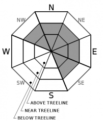
MODERATE avalanche danger continues above treeline and near treeline due to hard wind slabs. Areas of unstable snow are isolated, but the consequences of becoming caught in an avalanche are elevated due to the specifics of the current avalanche problem. LOW avalanche danger exists in wind protected areas below treeline. 

2. Moderate

?

Above Treeline
Heightened avalanche conditions on specific terrain features. Evaluate snow and terrain carefully; identify features of concern.

2. Moderate

?

Near Treeline
Heightened avalanche conditions on specific terrain features. Evaluate snow and terrain carefully; identify features of concern.

1. Low

?

Below Treeline
Generally safe avalanche conditions. Watch for unstable snow on isolated terrain features.
    Heightened avalanche conditions on specific terrain features. Evaluate snow and terrain carefully; identify features of concern.
Avalanche Problem 1: Wind Slab
  • Type ?
  • Aspect/Elevation ?
  • Likelihood ?
    Certain
    Very Likely
    Likely
    Possible
    Unlikely
  • Size ?
    Historic
    Very Large
    Large
    Small

Hard wind slabs are the avalanche concern at this time. This problem exists above treeline and near treeline on NW-N-NE-E-SE aspects. Instability lingers despite strength gains in the upper snowpack since the peak of instability on Dec 18. Minimal snow is available for drifting with today's strong SW winds. Any new wind slabs that form today will be small. The main focus is on the older wind slabs capable of creating size D2 avalanches with significant consequences from wide propagation and hard slab blocks in the debris flow.

Locations where drifting snow was deposited as hard wind slabs on top of much softer near surface facets are problematic.  Areas near treeline on NW-N-NE-E aspects that have both protection from previous NE winds and hards slabs from the recent SW winds are of particular concern. Heightened concern also exists for couloir features as greater snowpack variability over short distances is frequently encountered there.

Human triggering of hard wind slabs often occurs once an individual is well out onto the slab, close to a thinner slab trigger point such as an exposed rock, and often not by the first person on the slope.

Use the clues of recently wind drifted snow to identify areas of wind slab and adjust routes accordingly. Recently wind drifted snow exists below cornices, at and below rounded wind pillows, and where indicated by wind scouring vs deposition patterns along ridgelines.

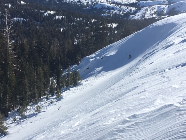
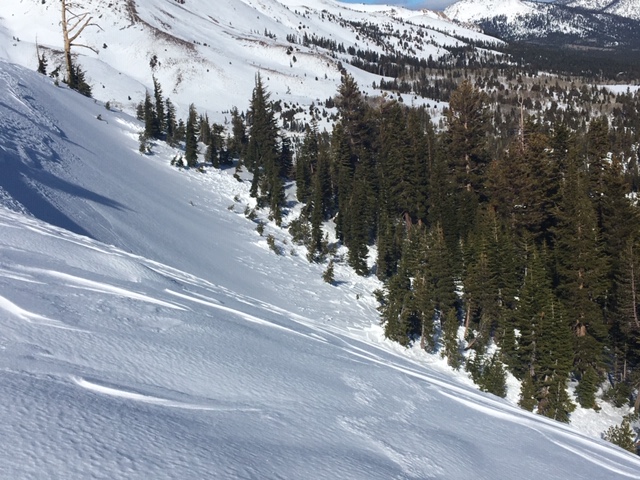
   New photos of the Dec 18 avalanche. For the photo on the right, the crown extended out of view past the prominent dead tree and around the corner for another 250 feet.

recent observations

The SW wind event on Dec 18 created hard wind slabs in near treeline and above treeline terrain. The most recent known avalanche activity occurred on Dec 18 (more info). Snowpit tests performed yesterday in the crown of a Dec 18 avalanche indicated both strength gains and lingering instability. Snowpit tests from around the forecast area targeting deeper into the snowpack have not indicated the presence of problematic weak layers. Near surface facets comprise the snow surface in wind protected areas on northerly aspects below treeline.

Weather and CURRENT CONDITIONS
weather summary

Ridgetop winds will increase today. This is about 12 hours earlier than previous forecasts. Ridgetop gusts to 80 mph are expected this afternoon, further increasing in speed tonight and Saturday. Sunshine and wind will prevail today and tomorrow. The next period of significant snowfall is forecast to begin late Saturday night and last into Sunday morning. Current snowfall forecasts are for 4 to 12 inches with the Sierra Crest heavily favored. Snow levels are expected around 5,000' to 5,500'.

CONDITIONS ALONG THE SIERRA CREST BETWEEN 8200 FT. AND 9200 FT. IN THE LAST 24 HOURS
6am temperature: 30 to 35 deg. F.
Max. temperature: 35 to 41 deg. F.
Average ridgetop wind direction: SW
Average ridgetop wind speed: 26 mph
Maximum ridgetop wind gust: 41 mph
New snowfall: 0 inches
Total snow depth: 44 to 50 inches
Two-Day Mountain Weather Forecast Produced in partnership with the Reno NWS
For 7000 ft. to 8000 ft.
Friday Friday Night Saturday
Weather: Mostly cloudy then becoming partly cloudy. Snow levels 7000 feet. Chance of precipitation is 0%. Partly cloudy. Snow levels below 7000 feet. Chance of precipitation is 0%. Sunny. Snow levels below 7000 feet. Chance of precipitation is 0%.
Temperatures: 39 to 44. deg. F. 27 to 32. deg. F. 38 to 43. deg. F.
Mid Slope Winds: Southwest 15 to 20 mph. Gusts up to 45 mph increasing to 55 mph in the afternoon. Southwest 15 to 20 mph increasing to 20 to 30 mph after midnight. Gusts up to 65 mph. Southwest 20 to 30 mph with gusts to 80 mph.
Expected snowfall: No accumulation. | SWE = none. No accumulation. | SWE = none. No accumulation. | SWE = none.
For 8000 ft. to 9000 ft.
Friday Friday Night Saturday
Weather: Partly cloudy. Snow levels below 7000 feet increasing to 7000 feet in the afternoon. Chance of precipitation is 0%. Partly cloudy. Snow levels below 7000 feet. Chance of precipitation is 0%. Sunny. Snow levels below 7000 feet. Chance of precipitation is 0%.
Temperatures: 35 to 40. deg. F. 25 to 30. deg. F. 34 to 39. deg. F.
Ridge Top Winds: Southwest 25 to 35 mph with gusts to 60 mph increasing to 30 to 45 mph with gusts to 80 mph in the afternoon. Southwest 35 to 55 mph with gusts to 90 mph. South 35 to 55 mph with gusts to 95 mph.
Expected snowfall: No accumulation. | SWE = none. No accumulation. | SWE = none. No accumulation. | SWE = none.
Disclaimer

This avalanche forecast is provided through a partnership between the Tahoe National Forest and the Sierra Avalanche Center. This forecast covers the Central Sierra Nevada Mountains between Yuba Pass on the north and Ebbetts Pass on the south. Click here for a map of the forecast area. This forecast applies only to backcountry areas outside established ski area boundaries. This forecast describes general avalanche conditions and local variations always occur. This forecast expires 24 hours after the posted time unless otherwise noted. The information in this forecast is provided by the USDA Forest Service who is solely responsible for its content.

For a recorded version of the avalanche forecast call (530) 587-3558 x258