THIS AVALANCHE FORECAST EXPIRED ON December 23, 2019 @ 7:03 am
Avalanche Forecast published on December 22, 2019 @ 7:03 am
Issued by Andy Anderson - Tahoe National Forest - Sierra Avalanche Center

New snow and wind today will cause the avalanche danger to increase to CONSIDERABLE in near and above treeline terrain as slabs of wind drifted snow become a problem. Human triggered wind slab avalanches will become likely. In more sheltered areas storm slab avalanches may become possible resulting in MODERATE avalanche danger. Variability in snowfall amounts and intensity during the storm will introduce some uncertainty around today's avalanche problems. 

3. Considerable

?

Above Treeline
Dangerous avalanche conditions. Careful snowpack evaluation, cautious route-finding and conservative decision-making essential.

3. Considerable

?

Near Treeline
Dangerous avalanche conditions. Careful snowpack evaluation, cautious route-finding and conservative decision-making essential.

2. Moderate

?

Below Treeline
Heightened avalanche conditions on specific terrain features. Evaluate snow and terrain carefully; identify features of concern.
    Dangerous avalanche conditions. Careful snowpack evaluation, cautious route-finding and conservative decision-making essential.
Avalanche Problem 1: Wind Slab
  • Type ?
  • Aspect/Elevation ?
  • Likelihood ?
    Certain
    Very Likely
    Likely
    Possible
    Unlikely
  • Size ?
    Historic
    Very Large
    Large
    Small

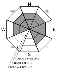
Continued gale force winds combined with new snow today will cause new wind slabs to form on leeward aspects. These slabs of newly drifted snow will likely form too fast to bond to the variety of old snow surfaces that they form on. Human triggered wind slab avalanches large enough to bury or injure a person will become likely by this afternoon. The largest and most fragile wind slabs will exist in near and above treeline terrain. Wind slabs could form on W-NW-NE-N-E-SE aspects and may exist in some unusual places due to the more southerly wind direction.

Blowing snow, cornices above a slope, drifted snow, and other wind created features can provide clues as to where wind slabs may be forming. Use this information to avoid wind loaded areas in favor of more sheltered terrain today. Not only will this help reduce exposure to avalanche danger it will also help locate areas of better snow and less wind.

Avalanche Problem 2: Storm Slab
  • Type ?
  • Aspect/Elevation ?
  • Likelihood ?
    Certain
    Very Likely
    Likely
    Possible
    Unlikely
  • Size ?
    Historic
    Very Large
    Large
    Small

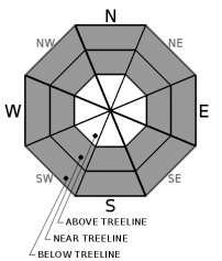
Intense snowfall, variable snow levels, and other changes during the storm may allow some slabs of soft snow to form above weaker snow in some areas today. These possible storm slabs would exist in areas that receive the most new snow and highest snowfall rates. In other areas that experience less intense snowfall and less accumulation, smaller loose dry sluffs may occur instead of storm slabs. The variability associated with this storm introduces some uncertainty around which of these problems will be more prevalent. 

Human-triggered shooting cracks, recent avalanches, or other clues like finding a softer layer of snow below a denser layer of snow can indicate that you are in an area where storm slabs may be a problem. Identify these areas and build safety margins that reduce your exposure to the potential hazard. 

recent observations

Yesterday observers reported a small skier triggered wind slab on a test slope on Castle Peak, shooting cracks on a wind-loaded test slope on Andesite Peak, wind slabs above softer snow on Judah, stubborn hard wind slabs in Munchkins, thin reactive wind slabs near the summit of Rubicon, and some reactive wind slabs and unstable test results from Tallac and around Ebbetts Pass. A high degree of variability existed in terms of the size and reactivity of wind slabs. Snow surfaces in these exposed near and above treeline areas ranged from scoured rain crusts to firm wind buff to hard wind slab to sastrugi covered areas. Strong winds and blowing snow were reported all along the Sierra Crest in near and above treeline areas. 

Soft unconsolidated snow and significant signs of settlement and consolidation existed in more sheltered areas on northerly aspects above 7500 ft. along the Sierra Crest and in the Ophir Creek drainage.

Below 7500 ft. observers reported wet snow surfaces.


Weather and CURRENT CONDITIONS
weather summary

The SW and SSW winds increased again during the night averaging in the 50 mph range with gusts between 100 and 113 mph. These gale force winds should continue through today before starting to decrease after midnight. Cloud cover and precipitation should move into the area today as a fast-moving winter storm impacts the region. The forecast calls for snowfall to start between 10 am and noon and continue through midnight with the most intense periods of snow occurring this afternoon. While 3 to 9 inches of snow is predicted, snowfall amounts and rates could vary significantly from place to place today with some areas along the Sierra Crest receiving up to a foot of new snow with snowfall rates of 1+ inches per hour at times. Snow level should start around 6000 ft with some fluctuations at the start of the storm before settling down to between 5000 and 6000 ft. for most of the snow. 

CONDITIONS ALONG THE SIERRA CREST BETWEEN 8200 FT. AND 9200 FT. IN THE LAST 24 HOURS
6am temperature: 30 to 37 deg. F.
Max. temperature: 34 to 41 deg. F.
Average ridgetop wind direction: SW and SSW
Average ridgetop wind speed: 50 to 55 mph
Maximum ridgetop wind gust: 113 mph
New snowfall: 0 inches
Total snow depth: 43 to 44 inches
Two-Day Mountain Weather Forecast Produced in partnership with the Reno NWS
For 7000 ft. to 8000 ft.
Sunday Sunday Night Monday
Weather: Partly cloudy then becoming cloudy. Chance of snow in the morning, then snow in the afternoon. Snow levels below 7000 feet. Chance of precipitation is 90%. Mostly cloudy then becoming partly cloudy. Snow likely in the evening, then slight chance of snow after midnight. Snow levels below 7000 feet. Chance of precipitation is 65%. Mostly cloudy. Chance of snow. Snow levels below 7000 feet. Chance of precipitation is 50%.
Temperatures: 39 to 44 deg. F. 14 to 20 deg. F. 26 to 31 deg. F.
Mid Slope Winds: South 20 to 35 mph with gusts to 50 mph. South 15 to 25 mph. Gusts up to 45 mph decreasing to 35 mph after midnight. East around 15 mph in the morning becoming light. Gusts up to 25 mph.
Expected snowfall: 70% probability of 3 to 7 inches. 30% probability of 7 to 10 inches. | SWE = 0.30-0.55 inch. 70% probability of 1 to 2 inches. 30% probability of 2 to 4 inches. | SWE = up to 0.25 inch. up to 1 inch. | SWE = less than 0.10 inch.
For 8000 ft. to 9000 ft.
Sunday Sunday Night Monday
Weather: Partly cloudy then becoming cloudy. Chance of snow in the morning, then snow in the afternoon. Snow levels below 7000 feet. Chance of precipitation is 95%. Mostly cloudy then becoming partly cloudy. Snow likely. Snow levels below 7000 feet. Chance of precipitation is 70%. Mostly cloudy. Chance of snow. Snow levels below 7000 feet. Chance of precipitation is 50%.
Temperatures: 36 to 41 deg. F. 12 to 17 deg. F. 22 to 27 deg. F.
Ridge Top Winds: South 35 to 55 mph with gusts to 90 mph decreasing to 30 to 45 mph with gusts to 70 mph in the afternoon. Southwest 25 to 35 mph with gusts to 55 mph becoming south 15 to 25 mph with gusts to 40 mph after midnight. East around 15 mph with gusts to 30 mph.
Expected snowfall: 70% probability of 4 to 8 inches. 30% probability of 8 to 12 inches. | SWE = 0.30-0.55 inch. 70% probability of 1 to 2 inches. 30% probability of 2 to 4 inches. | SWE = up to 0.25 inch. up to 2 inches. | SWE = less than 0.10 inch.
Disclaimer

This avalanche forecast is provided through a partnership between the Tahoe National Forest and the Sierra Avalanche Center. This forecast covers the Central Sierra Nevada Mountains between Yuba Pass on the north and Ebbetts Pass on the south. Click here for a map of the forecast area. This forecast applies only to backcountry areas outside established ski area boundaries. This forecast describes general avalanche conditions and local variations always occur. This forecast expires 24 hours after the posted time unless otherwise noted. The information in this forecast is provided by the USDA Forest Service who is solely responsible for its content.

For a recorded version of the avalanche forecast call (530) 587-3558 x258