THIS AVALANCHE FORECAST EXPIRED ON December 24, 2019 @ 6:56 am
Avalanche Forecast published on December 23, 2019 @ 6:56 am
Issued by Steve Reynaud - Tahoe National Forest

MODERATE avalanche danger will exist at all elevations today.  Wind slabs that formed yesterday will be a concern in near and above treeline areas.  Loose dry avalanches will be possible in below treeline areas.  Human triggered avalanches are possible today.

2. Moderate

?

Above Treeline
Heightened avalanche conditions on specific terrain features. Evaluate snow and terrain carefully; identify features of concern.

2. Moderate

?

Near Treeline
Heightened avalanche conditions on specific terrain features. Evaluate snow and terrain carefully; identify features of concern.

2. Moderate

?

Below Treeline
Heightened avalanche conditions on specific terrain features. Evaluate snow and terrain carefully; identify features of concern.
    Heightened avalanche conditions on specific terrain features. Evaluate snow and terrain carefully; identify features of concern.
Avalanche Problem 1: Wind Slab
  • Type ?
  • Aspect/Elevation ?
  • Likelihood ?
    Certain
    Very Likely
    Likely
    Possible
    Unlikely
  • Size ?
    Historic
    Very Large
    Large
    Small

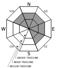
Strong to gale force SW winds yesterday and last night have created wind slabs on NW-N-NE-E-SE aspects in near and above treeline terrain.  4 to 15'' of new snow has fallen throughout the area and has been available for wind transport.  Winds have shifted to the SE this morning and are forecasted to be light through today.  Wind slabs that were formed yesterday could still be reactive to human triggering today.

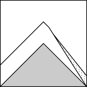
Signs of wind slab avalanche problems will include: recent wind slab avalanches, new cornices, wind pillows, shooting cracks in wind loaded terrain, and snow surface scouring.  Newly formed wind slabs could be multiple feet deep in areas that received the higher end snow totals yesterday.

Avalanche Problem 2: Loose Dry
  • Type ?
  • Aspect/Elevation ?
  • Likelihood ?
    Certain
    Very Likely
    Likely
    Possible
    Unlikely
  • Size ?
    Historic
    Very Large
    Large
    Small

Recent storm snow from yesterday is mostly right side up with the storm starting out warm and ending colder.  Winds decreased into the early morning hours as snowfall continued.  In steep below treeline terrain, loose dry avalanches will be possible today.  These are generally expected to be small surface sloughs, but could be large enough to take a backcountry user for a ride.  Loose dry avalanches could run fast and be especially problematic in areas with secondary exposure, terrain traps, or complex terrain

In areas where sloughing is occurring, use good terrain management techniques to limit exposure to other obstacles such as rocks, cliffs, or trees. 

recent observations

On Rubicon Peak, West Shore area, the new storm snow bonded well to the variety of snow surfaces.  Moderate wind transport was observed with only minor wind slab development and few signs of instabilities in the newly formed wind slabs.

Convective snow showers were reported from the Donner Summit area.  Moderate to heavy snowfall occurred with multiple breaks through the mid day with strong SW winds. 


Weather and CURRENT CONDITIONS
weather summary

Anywhere from 4 to 15'' of storm snow fell yesterday and last night throughout the forecast area.  Depending on location, these convective snow bands favored some areas much more than others.  Up to 2'' of light snow is forecasted for today with snow levels near 5000'.  Southeast flow today should keep winds light below 15mph for the day.  Light winds with slightly below average temperatures are expected into the weekend.

CONDITIONS ALONG THE SIERRA CREST BETWEEN 8200 FT. AND 9200 FT. IN THE LAST 24 HOURS
6am temperature: 21 to 27 deg. F.
Max. temperature: 39 deg. F.
Average ridgetop wind direction: SW shifting to SE
Average ridgetop wind speed: 30 to 50 mph
Maximum ridgetop wind gust: 112 mph
New snowfall: 5 to 13 inches
Total snow depth: 45 to 56 inches
Two-Day Mountain Weather Forecast Produced in partnership with the Reno NWS
For 7000 ft. to 8000 ft.
Monday Monday Night Tuesday
Weather: Cloudy. Snow likely. Snow levels below 7000 feet. Chance of precipitation is 70%. Mostly cloudy. Snow likely. Snow levels below 7000 feet. Chance of precipitation is 60%. Partly cloudy. Chance of snow. Snow levels below 7000 feet. Chance of precipitation is 25%.
Temperatures: 27 to 32. deg. F. 17 to 22. deg. F. 25 to 30. deg. F.
Mid Slope Winds: Light winds. Light winds. Southwest around 15 mph with gusts to 30 mph.
Expected snowfall: 80% probability up to 2 inches. 20% probability of 2 to 4 inches. | SWE = up to 0.15 inch. up to 2 inches. | SWE = less than 0.10 inch. up to 1 inch. | SWE = less than 0.10 inch.
For 8000 ft. to 9000 ft.
Monday Monday Night Tuesday
Weather: Cloudy. Snow likely. Snow levels below 7000 feet. Chance of precipitation is 70%. Mostly cloudy. Snow likely. Snow levels below 7000 feet. Chance of precipitation is 70%. Partly cloudy. Chance of snow. Snow levels below 7000 feet. Chance of precipitation is 30%.
Temperatures: 22 to 27. deg. F. 14 to 19. deg. F. 21 to 26. deg. F.
Ridge Top Winds: Southeast around 15 mph in the morning becoming light. Light winds becoming southwest around 15 mph after midnight. Southwest 15 to 20 mph with gusts to 35 mph.
Expected snowfall: 80% probability of 1 to 2 inches. 20% probability of 2 to 4 inches. | SWE = up to 0.15 inch. up to 2 inches. | SWE = less than 0.10 inch. up to 1 inch. | SWE = less than 0.10 inch.
Disclaimer

This avalanche forecast is provided through a partnership between the Tahoe National Forest and the Sierra Avalanche Center. This forecast covers the Central Sierra Nevada Mountains between Yuba Pass on the north and Ebbetts Pass on the south. Click here for a map of the forecast area. This forecast applies only to backcountry areas outside established ski area boundaries. This forecast describes general avalanche conditions and local variations always occur. This forecast expires 24 hours after the posted time unless otherwise noted. The information in this forecast is provided by the USDA Forest Service who is solely responsible for its content.

For a recorded version of the avalanche forecast call (530) 587-3558 x258