THIS AVALANCHE FORECAST EXPIRED ON December 26, 2019 @ 6:52 am
Avalanche Forecast published on December 24, 2019 @ 6:52 am
Issued by Steve Reynaud - Tahoe National Forest

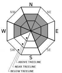
MODERATE avalanche danger will exist over the next two days due to a wind slab avalanche problem in near and above treeline terrain.  LOW avalanche danger will be in below treeline areas.  This two day avalanche forecast will be updated on Thursday morning by 7am.

2. Moderate

?

Above Treeline
Heightened avalanche conditions on specific terrain features. Evaluate snow and terrain carefully; identify features of concern.

2. Moderate

?

Near Treeline
Heightened avalanche conditions on specific terrain features. Evaluate snow and terrain carefully; identify features of concern.

1. Low

?

Below Treeline
Generally safe avalanche conditions. Watch for unstable snow on isolated terrain features.
    Heightened avalanche conditions on specific terrain features. Evaluate snow and terrain carefully; identify features of concern.
Avalanche Problem 1: Wind Slab
  • Type ?
  • Aspect/Elevation ?
  • Likelihood ?
    Certain
    Very Likely
    Likely
    Possible
    Unlikely
  • Size ?
    Historic
    Very Large
    Large
    Small

SW winds will be on the increase today, tonight, and tomorrow.  Winds are forecasted to slightly shift to the S on Wednesday.  Low density storm snow from Sunday and Monday will be easy to wind transport as the S/SW winds increase into the moderate to strong speed range.  New wind slab formation will start to occur today and continue through Wednesday in near and above treeline areas. 

Blowing snow, fresh cornices, shooting cracks, and wind scouring along ridges will all be indicators of current wind slab development.  Identify where wind slabs may exist and communicate with your group on how best to manage terrain. 

recent observations

Loose dry sluffing was common in steeper terrain on Castle Peak (Donner Summit area) and at Frog Lakes (Carson Pass area) yesterday.  

Little to no evidence of unstable wind slabs were observed on Tamarack Peak (Mt. Rose area), Rubicon Peak ( West Shore area), and Castle and Andesite Peaks (Donner Summit area).


Weather and CURRENT CONDITIONS
weather summary

Below average temperatures with a chance of light snow will be possible over the next 2 days.  The best chances of snow showers will be along the Sierra Crest with limited spillover expected.  S/SW winds will increase today, tonight, and tomorrow and will generally be in the moderate range with some strong gusts.  Clearing skies, cold temperatures, and an easterly flow is expected to move into the area on Thursday.  High pressure should stick around through Saturday before another storm is possible.

CONDITIONS ALONG THE SIERRA CREST BETWEEN 8200 FT. AND 9200 FT. IN THE LAST 24 HOURS
6am temperature: 14 to 21 deg. F.
Max. temperature: 33 deg. F.
Average ridgetop wind direction: E shifting to SW
Average ridgetop wind speed: Light increasing to 10 to 20 mph
Maximum ridgetop wind gust: 34 mph
New snowfall: 2 to 5 inches
Total snow depth: 47 to 57 inches
Two-Day Mountain Weather Forecast Produced in partnership with the Reno NWS
For 7000 ft. to 8000 ft.
Tuesday Tuesday Night Wednesday
Weather: Partly cloudy. Slight chance of snow. Snow levels below 7000'. Chance of precipitation is 20%. Mostly cloudy. Slight chance of snow. Snow levels below 7000'. Chance of precipitation is 15%. Mostly cloudy. Chance of snow. Snow levels below 7000'. Chance of precipitation is 50%.
Temperatures: 26 to 31 deg. F. 14 to 20 deg. F. 25 to 30 deg. F.
Mid Slope Winds: Light winds becoming SW around 15mph with gusts up to 25mph in the afternoon. Southwest around 15mph in the evening then becoming light. Gusts up to 30mph. Light winds.
Expected snowfall: Up to 1''. | SWE =.10'' Up to 1''| SWE = Trace Up to 2''| SWE =Less than .10''
For 8000 ft. to 9000 ft.
Tuesday Tuesday Night Wednesday
Weather: Partly cloudy. Chance of snow. Snow levels below 7000'. Chance of precipitation is 25%. Mostly cloudy. Slight chance of snow in the evening. Snow levels below 7000'. Chance of precipitation is 15%. Mostly cloudy. Chance of snow. Snow levels below 7000'. Chance of precipitation is 50%.
Temperatures: 22 to 28 deg. F. 12 to 17 deg. F. 20 to 26 deg. F.
Ridge Top Winds: Southwest 15 to 20mph with gusts to 30mph. Southwest 15 to 25mph with gusts to 35mph. South around 15mph with gusts to 30mph.
Expected snowfall: Up to 1'' | SWE = Less than .10'' Up to 1'' | SWE = Trace Up to 2''| SWE = .10''
Disclaimer

This avalanche forecast is provided through a partnership between the Tahoe National Forest and the Sierra Avalanche Center. This forecast covers the Central Sierra Nevada Mountains between Yuba Pass on the north and Ebbetts Pass on the south. Click here for a map of the forecast area. This forecast applies only to backcountry areas outside established ski area boundaries. This forecast describes general avalanche conditions and local variations always occur. This forecast expires 24 hours after the posted time unless otherwise noted. The information in this forecast is provided by the USDA Forest Service who is solely responsible for its content.

For a recorded version of the avalanche forecast call (530) 587-3558 x258