THIS AVALANCHE FORECAST EXPIRED ON December 28, 2019 @ 6:47 am
Avalanche Forecast published on December 27, 2019 @ 6:47 am
Issued by Brandon Schwartz - Tahoe National Forest

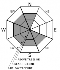
MODERATE avalanche danger continues above treeline and near treeline as ENE wind continues to drift snow and form wind slabs. LOW avalanche danger continues in wind protected areas below treeline.

2. Moderate

?

Above Treeline
Heightened avalanche conditions on specific terrain features. Evaluate snow and terrain carefully; identify features of concern.

2. Moderate

?

Near Treeline
Heightened avalanche conditions on specific terrain features. Evaluate snow and terrain carefully; identify features of concern.

1. Low

?

Below Treeline
Generally safe avalanche conditions. Watch for unstable snow on isolated terrain features.
    Heightened avalanche conditions on specific terrain features. Evaluate snow and terrain carefully; identify features of concern.
Avalanche Problem 1: Wind Slab
  • Type ?
  • Aspect/Elevation ?
  • Likelihood ?
    Certain
    Very Likely
    Likely
    Possible
    Unlikely
  • Size ?
    Historic
    Very Large
    Large
    Small

ENE winds continue to blow over ridgetops in the moderate to strong range. Wind speeds reached the strongest yet for the current wind event after sunset yesterday. While wind slab formation reported yesterday was fairly minimal, wind slabs are expected to have gradually grown larger and thicker last night and may continue to do so today. Recently formed wind slabs exist near treeline and above treeline on SE-S-SW-W-NW-N aspects. Avalanche size up to D2 is possible.

Look for signs of where the most recent drifting and wind slab formation has occurred. Identify clues such as blowing snow, wind scouring along ridges, snow surface patterns indicative of scouring vs deposition, new wind pillows, and shooting cracks as indicators of wind slab development. Use these clues to identify where problematic wind slabs may exist and communicate within your group on how best to manage the combination of terrain and the avalanche problem.

recent observations

* Foggy conditions were reported yesterday from the Ebbetts Pass, Carson Pass, and Luther Pass areas. Surface snow was reported to remain dry.

* Near treeline and above treeline blowing snow was reported yesterday. Fresh cornices were building, but new wind slab formation was limited.

* Some minor cracking was reported around the edges of newly formed wind slabs, but no test slope failures or unstable snowpit test results were noted yesterday.

Weather and CURRENT CONDITIONS
weather summary

Gusty ENE winds will continue over the ridgetops through tomorrow. Near to below average air temperatures will continue for the next several days. Sunny skies are expected today and tomorrow. The next storm system is forecast to pass through the region Sunday/Monday, bringing the potential for snowfall. 

CONDITIONS ALONG THE SIERRA CREST BETWEEN 8200 FT. AND 9200 FT. IN THE LAST 24 HOURS
6am temperature: 11 to 18 deg. F.
Max. temperature: 17 to 22 deg. F.
Average ridgetop wind direction: ENE
Average ridgetop wind speed: 41 mph
Maximum ridgetop wind gust: 75 mph
New snowfall: 0 to trace inches
Total snow depth: 46 to 53 inches
Two-Day Mountain Weather Forecast Produced in partnership with the Reno NWS
For 7000 ft. to 8000 ft.
Friday Friday Night Saturday
Weather: Sunny. Snow levels below 7000 feet. Chance of precipitation is 0%. Partly cloudy then becoming clear. Snow levels below 7000 feet. Chance of precipitation is 0%. Sunny. Snow levels below 7000 feet. Chance of precipitation is 0%.
Temperatures: 29 to 34. deg. F. 14 to 19. deg. F. 33 to 38. deg. F.
Mid Slope Winds: Light winds. Gusts up to 25 mph in the afternoon. Light winds. Light winds becoming northeast around 15 mph with gusts to 25 mph in the afternoon.
Expected snowfall: No accumulation. | SWE = none. No accumulation. | SWE = none. No accumulation. | SWE = none.
For 8000 ft. to 9000 ft.
Friday Friday Night Saturday
Weather: Sunny. Snow levels below 7000 feet. Chance of precipitation is 0%. Partly cloudy then becoming clear. Snow levels below 7000 feet. Chance of precipitation is 0%. Sunny. Snow levels below 7000 feet. Chance of precipitation is 0%.
Temperatures: 26 to 31. deg. F. 17 to 22. deg. F. 29 to 34. deg. F.
Ridge Top Winds: Northeast 15 to 30 mph with gusts to 60 mph. East 15 to 25 mph. Gusts up to 55 mph decreasing to 40 mph after midnight. Northeast 15 to 25 mph with gusts to 50 mph.
Expected snowfall: No accumulation. | SWE = none. No accumulation. | SWE = none. No accumulation. | SWE = none.
Disclaimer

This avalanche forecast is provided through a partnership between the Tahoe National Forest and the Sierra Avalanche Center. This forecast covers the Central Sierra Nevada Mountains between Yuba Pass on the north and Ebbetts Pass on the south. Click here for a map of the forecast area. This forecast applies only to backcountry areas outside established ski area boundaries. This forecast describes general avalanche conditions and local variations always occur. This forecast expires 24 hours after the posted time unless otherwise noted. The information in this forecast is provided by the USDA Forest Service who is solely responsible for its content.

For a recorded version of the avalanche forecast call (530) 587-3558 x258