THIS AVALANCHE FORECAST EXPIRED ON December 9, 2019 @ 6:59 am
Avalanche Forecast published on December 8, 2019 @ 6:59 am
Issued by Andy Anderson - Tahoe National Forest - Sierra Avalanche Center

Significant wind and new heavy snow during the storm have left large unstable slabs of drifted snow (wind slabs) on exposed near and above treeline slopes. In these areas, CONSIDERABLE avalanche danger exists and human-triggered avalanches are likely. In more sheltered below treeline areas, new heavy snow on top of older, lighter, weaker snow means MODERATE avalanche danger due to the possibility of storm slab avalanches.  

3. Considerable

?

Above Treeline
Dangerous avalanche conditions. Careful snowpack evaluation, cautious route-finding and conservative decision-making essential.

3. Considerable

?

Near Treeline
Dangerous avalanche conditions. Careful snowpack evaluation, cautious route-finding and conservative decision-making essential.

2. Moderate

?

Below Treeline
Heightened avalanche conditions on specific terrain features. Evaluate snow and terrain carefully; identify features of concern.
    Dangerous avalanche conditions. Careful snowpack evaluation, cautious route-finding and conservative decision-making essential.
Avalanche Problem 1: Wind Slab
  • Type ?
  • Aspect/Elevation ?
  • Likelihood ?
    Certain
    Very Likely
    Likely
    Possible
    Unlikely
  • Size ?
    Historic
    Very Large
    Large
    Small

Gale force SW winds have drifted snow onto the leeward NW-N-NE-E-SE aspects. These slabs of wind drifted snow will remain fragile today. Human-triggered wind slab avalanches will be likely and some natural wind slab avalanches may be possible. Exposed areas in near and above treeline terrain receive the most wind-loading and will hold the largest and most fragile wind slabs. However, some wind slabs may exist on a few below treeline slopes due to the strength of the winds. Wind slabs avalnaches could be large (D3) and dangerous today.

Use clues like blowing snow, cornices above a slope, drifted snow, and other wind created textures to identify where wind slabs may exist. Avoiding these areas in favor of sheltered slopes without signs of the storm slabs mentioned below will provide a better safety margin for today. More consistent and enjoyable snow conditions may also exist on the sheltered slopes.

Avalanche Problem 2: Storm Slab
  • Type ?
  • Aspect/Elevation ?
  • Likelihood ?
    Certain
    Very Likely
    Likely
    Possible
    Unlikely
  • Size ?
    Historic
    Very Large
    Large
    Small

The recent storm snow started out heavier than the old snow it accumulated on. Storm slab avalanches remain possible today since the additional weight of a person in the right spot may cause the storm snow to break away from the old snow. Storm slabs would be more fragile in the few areas where they rest on top of a weak layer of feathery snow (surface hoar). Steep open slopes in below treeline terrain hold the best potential for storm slab instabilities. As the snow settles this upside-down snow structure will consolidate.

Look out for signs of recent avalanche activity, shooting cracks, or feeling lighter snow below denser snow in hand pits or while probing. These clues can help identify areas with potential storm slabs. Seeking out lower angle terrain without steeper terrain above it can provide quality snow and a good safety margin if there is any doubt about potential instabilities. 

recent observations

* Yesterday observers found a mix of conditions with rain-soaked snow at lower elevations and new heavy snow at higher elevations. This new heavy snow rested on lighter older snow. 

* On Incline Lake Peak, the new snow rested on top of a thin layer of surface hoar in some areas and snowpit tests yielded potentially unstable results. 

* On Carson Pass, snowmobile slope cuts in near and below treeline terrain did not produce signs of instability before midday. Observers also reported significantly more blowing snow on the higher more exposed peaks in the distance. 

Weather and CURRENT CONDITIONS
weather summary

This storm has deposited 10 to 17 inches of snow in areas above 8000 ft. since yesterday. Gale force SW winds with gusts up 124 mph accompanied the precipitation. Snow levels started high and then dropped to around 6000 ft. last night. The storm should begin to wind down today with a decrease in winds and snowfall intensity. Temperatures should remain cold with snow levels below 6000 ft. By this evening, the snow showers should come to an end and the winds should shift to the NE and E and decrease.

CONDITIONS ALONG THE SIERRA CREST BETWEEN 8200 FT. AND 9200 FT. IN THE LAST 24 HOURS
6am temperature: 24 to 30 deg. F.
Max. temperature: 30 to 35 deg. F.
Average ridgetop wind direction: SW
Average ridgetop wind speed: 45 to 55 mph
Maximum ridgetop wind gust: 124 mph
New snowfall: 10 to 17 inches
Total snow depth: 50 to 60 inches
Two-Day Mountain Weather Forecast Produced in partnership with the Reno NWS
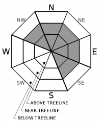
For 7000 ft. to 8000 ft.
Sunday Sunday Night Monday
Weather: Cloudy. Snow showers in the morning, then snow showers likely in the afternoon. Snow levels below 7000 feet. Chance of precipitation is 80%. Mostly cloudy then becoming partly cloudy. Snow levels below 7000 feet. Chance of precipitation is 5%. Partly cloudy then becoming sunny. Snow levels below 7000 feet. Chance of precipitation is 0%.
Temperatures: 31 to 36 deg. F. 18 to 24 deg. F. 34 to 39 deg. F.
Mid Slope Winds: Southwest 15 to 25 mph. Gusts up to 40 mph in the morning. Light winds. Light winds.
Expected snowfall: 70% probability of 3 to 7 inches. 30% probability of 2 to 4 inches. | SWE = up to 0.20 inch. No accumulation. | SWE = none. No accumulation. | SWE = none.
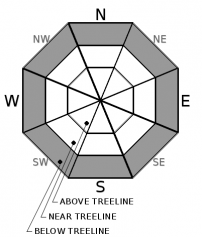
For 8000 ft. to 9000 ft.
Sunday Sunday Night Monday
Weather: Mostly cloudy. Snow showers in the morning, then snow showers likely in the afternoon. Snow levels below 7000 feet. Chance of precipitation is 80%. Mostly cloudy then becoming partly cloudy. Snow levels below 7000 feet. Chance of precipitation is 5%. Partly cloudy then becoming sunny. Snow levels below 7000 feet. Chance of precipitation is 0%.
Temperatures: 27 to 32 deg. F. 16 to 21 deg. F. 29 to 34 deg. F.
Ridge Top Winds: Southwest 20 to 35 mph decreasing to 15 to 25 mph in the afternoon. Gusts up to 60 mph. Light winds becoming northeast around 15 mph after midnight. East around 15 mph.
Expected snowfall: 70% probability of 3 to 8 inches. 30% probability of 2 to 5 inches. | SWE = up to 0.20 inch. No accumulation. | SWE = none. No accumulation. | SWE = none.
Disclaimer

This avalanche forecast is provided through a partnership between the Tahoe National Forest and the Sierra Avalanche Center. This forecast covers the Central Sierra Nevada Mountains between Yuba Pass on the north and Ebbetts Pass on the south. Click here for a map of the forecast area. This forecast applies only to backcountry areas outside established ski area boundaries. This forecast describes general avalanche conditions and local variations always occur. This forecast expires 24 hours after the posted time unless otherwise noted. The information in this forecast is provided by the USDA Forest Service who is solely responsible for its content.

For a recorded version of the avalanche forecast call (530) 587-3558 x258