THIS AVALANCHE FORECAST EXPIRED ON February 2, 2019 @ 6:46 am
Avalanche Forecast published on February 1, 2019 @ 6:46 am
Issued by Brandon Schwartz - Tahoe National Forest

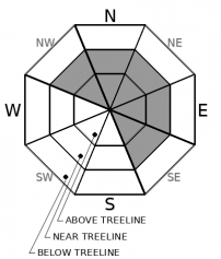
LOW avalanche danger will occur for most of today at all elevations. Following the onset of precipitation, the trend of increasing avalanche danger will begin with MODERATE avalanche danger forming tonight as wind slabs develop near treeline and above treeline. An avalanche watch has been issued for expected periods of HIGH avalanche danger Saturday morning into Tuesday morning.

2. Moderate

?

Above Treeline
Heightened avalanche conditions on specific terrain features. Evaluate snow and terrain carefully; identify features of concern.

2. Moderate

?

Near Treeline
Heightened avalanche conditions on specific terrain features. Evaluate snow and terrain carefully; identify features of concern.

1. Low

?

Below Treeline
Generally safe avalanche conditions. Watch for unstable snow on isolated terrain features.
    Heightened avalanche conditions on specific terrain features. Evaluate snow and terrain carefully; identify features of concern.
Avalanche Problem 1: Wind Slab
  • Type ?
  • Aspect/Elevation ?
  • Likelihood ?
    Certain
    Very Likely
    Likely
    Possible
    Unlikely
  • Size ?
    Historic
    Very Large
    Large
    Small

For most of the day today, no specific avalanche problem will exist. Following the onset of snowfall late today, a wind slab avalanche problem will begin to form this evening. The vast majority of wind slabs that form within the next 24 hours will occur near treeline and above treeline on NW-N-NE-E-SE aspects. Slopes below or adjacent to cornice features will be the most suspect.

Normal caution will be appropriate travel advice for most of today. This evening into the predawn hours Saturday, a wind slab problem will need to be managed by identifying and carefully evaluating travel on or below slopes where wind drifted snow is depositing.

recent observations

*Recent observations from around the forecast area have identified melt-freeze snow surface conditions on E-SE-S-SW-W aspects. NW-N-NE aspects have either thin melt-freeze crust on the surface or have escaped snow surface melt in the steeper shaded areas.

* Some small surface hoar was noted on N-NE aspects yesterday on Stevens Peak (Carson Pass area) in near to above treeline terrain. Any locations where surface hoar persists and becomes buried by new snow tonight could have greater instability in the coming days. Have a look around out there today for surface hoar that could become buried.

* Below the snow surface, the existing snowpack is well bonded on all aspects and is in good condition to handle new snow loading. Avalanche activity during the upcoming storm cycle is expected to occur either at the old/new snow interface or within the storm snow.

Weather and CURRENT CONDITIONS
weather summary

Two storm systems are forecast to impact the forecast area starting later today and continuing into Tuesday. A warm to cold progression is expected with these storms. Forecast snow totals tonight through Tuesday are 3 to 6 feet above 7,000'. Increasing ridgetop winds out of the SSW along with increasing cloud cover will occur for most of the daylight hours today. Precipitation is expected to begin around 4 pm today with snow level around 6,500' to 7,000'. Snow level is forecast to lower rapidly Saturday morning along with a substantial increase in snowfall rates. For the latest info on this storm cycle, check with NWS Reno.

CONDITIONS ALONG THE SIERRA CREST BETWEEN 8200 FT. AND 9200 FT. IN THE LAST 24 HOURS
6am temperature: 28 to 32 deg. F.
Max. temperature: 39 to 42 deg. F.
Average ridgetop wind direction: NE shifting to SSW
Average ridgetop wind speed: NE 25 mph | SSW 30 mph
Maximum ridgetop wind gust: NE 34 mph | SSW 49 mph
New snowfall: 0 inches
Total snow depth: 60 to 79 inches
Two-Day Mountain Weather Forecast Produced in partnership with the Reno NWS
For 7000 ft. to 8000 ft.
Friday Friday Night Saturday
Weather: Mostly cloudy to cloudy. Slight chance of snow in the afternoon. Snow levels 7000 feet. Chance of precipitation is 10%. Cloudy. Chance of snow in the evening, then snow after midnight. Snow levels below 7000 feet. Chance of precipitation is 90%. Snow. Snow levels below 7000 feet. Chance of precipitation is 100%.
Temperatures: 40 to 45 deg. F. 28 to 33 deg. F. 30 to 35 deg. F.
Mid Slope Winds: South 15 to 25 mph. Gusts up to 35 mph increasing to 45 mph in the afternoon. South 15 to 25 mph. Gusts up to 45 mph increasing to 55 mph after midnight. Southeast 15 to 20 mph. Gusts up to 40 mph decreasing to 30 mph in the afternoon.
Expected snowfall: No accumulation. | SWE = none. 80% probability of 1 to 5 inches. 20% probability of 5 to 8 inches. | SWE = 0.15-0.40 inch. 70% probability of 12 to 20 inches. 30% probability of 8 to 12 inches. | SWE = 1.00-1.50 inches.
For 8000 ft. to 9000 ft.
Friday Friday Night Saturday
Weather: Mostly cloudy to cloudy. Slight chance of snow in the afternoon. Snow levels 7000 feet. Chance of precipitation is 10%. Cloudy. Chance of snow in the evening, then snow after midnight. Snow levels below 7000 feet. Chance of precipitation is 85%. Heavy snow. Snow levels below 7000 feet. Chance of precipitation is 100%.
Temperatures: 37 to 42 deg. F. 25 to 30 deg. F. 28 to 33 deg. F.
Ridge Top Winds: Southwest 15 to 30 mph shifting to the south 25 to 35 mph in the afternoon. Gusts up to 70 mph. South 30 to 45 mph with gusts to 85 mph. Southeast 30 to 50 mph with gusts to 90 mph decreasing to 20 to 35 mph with gusts to 70 mph in the afternoon.
Expected snowfall: No accumulation. | SWE = none. 80% probability of 2 to 6 inches. 20% probability of 6 to 10 inches. | SWE = 0.20-0.45 inch. 80% probability of 14 to 22 inches. 20% probability of 22 to 30 inches. | SWE = 1.10-1.60 inches.
Disclaimer

This avalanche forecast is provided through a partnership between the Tahoe National Forest and the Sierra Avalanche Center. This forecast covers the Central Sierra Nevada Mountains between Yuba Pass on the north and Ebbetts Pass on the south. Click here for a map of the forecast area. This forecast applies only to backcountry areas outside established ski area boundaries. This forecast describes general avalanche conditions and local variations always occur. This forecast expires 24 hours after the posted time unless otherwise noted. The information in this forecast is provided by the USDA Forest Service who is solely responsible for its content.

For a recorded version of the avalanche forecast call (530) 587-3558 x258