THIS AVALANCHE FORECAST EXPIRED ON February 17, 2019 @ 6:45 am
Avalanche Forecast published on February 16, 2019 @ 6:45 am
Issued by Brandon Schwartz - Tahoe National Forest

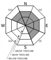
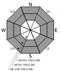
HIGH avalanche danger continues for another 24 hours at all elevations. Travel in or below avalanche terrain is not recommended. Maintain awareness of your location relative to avalanche terrain and keep a wide margin for error. Remain clear of avalanche runout zones.

4. High

?

Above Treeline
Very dangerous avalanche conditions. Travel in avalanche terrain not recommended.

4. High

?

Near Treeline
Very dangerous avalanche conditions. Travel in avalanche terrain not recommended.

4. High

?

Below Treeline
Very dangerous avalanche conditions. Travel in avalanche terrain not recommended.
    Very dangerous avalanche conditions. Travel in avalanche terrain not recommended.
Avalanche Problem 1: Wind Slab
  • Type ?
  • Aspect/Elevation ?
  • Likelihood ?
    Certain
    Very Likely
    Likely
    Possible
    Unlikely
  • Size ?
    Historic
    Very Large
    Large
    Small

Little has changed as the storm cycle continues. Periods of moderate to high intensity snowfall and moderate to strong SW winds are continuing to drift snow and keep the wind slab avalanche problem ongoing. The vast majority of wind slabs exist near treeline and above treeline on NW-N-NE-E-SE aspects. Wind slabs may be encountered to a lesser extent on other aspects or in below treeline areas. Avalanche size up to D3 is expected (could bury a car, destroy a house, or break a few trees).

Be aware of the potential for avalanches from above running down into lower angle treed areas. Route plan carefully, anticipating low visibility obscuring the view of overhead avalanche start zones.

Avalanche Problem 2: Storm Slab
  • Type ?
  • Aspect/Elevation ?
  • Likelihood ?
    Certain
    Very Likely
    Likely
    Possible
    Unlikely
  • Size ?
    Historic
    Very Large
    Large
    Small

Continued development of unstable storm slabs remains likely from additional periods of high intensity snowfall today and tonight. Storm slabs are expected in wind protected areas mainly near and below treeline and may be encountered on any aspect. Avalanche size up to D2 is expected (could bury or injure a person).

Route plan carefully to avoid avalanche terrain. If areas of questionable slope steepness are encountered during travel, use an inclinometer to measure slope angle in order to assist in data based decision making. Allow a margin for error. Be aware of the potential for steeper slopes above.

recent observations

* Evidence of wind slab and storm slab avalanche problems were observed yesterday near Little Truckee Summit (Independence Lake area).

* Snow levels peaked Thursday morning up around 8,500' to 9,000'. Initial observations yesterday indicated a good bond between the refreezing rain layer and the new snow above it.

* New snow accumulations from this storm cycle are running 2 to 6 feet thus far in wind protected areas.

* Visibility in the backcountry has been poor with limited ability to see into avalanche start zones and assess for natural avalanche activity.

Weather and CURRENT CONDITIONS
weather summary

The current storm cycle continues with increasing snowfall intensity expected later this morning into this afternoon. Snowfall intensity may lull late this afternoon. This is expected to be followed by a second round of increasing snowfall intensity late tonight. Ridgetop winds out of the SW are on a decreasing trend but remain strong in speed. Winds are forecast to continue to gradually decrease and shift to the NW tomorrow. The current storm cycle is expected to come to an end by tomorrow afternoon.

CONDITIONS ALONG THE SIERRA CREST BETWEEN 8200 FT. AND 9200 FT. IN THE LAST 24 HOURS
6am temperature: 12 to 17 deg. F.
Max. temperature: 14 to 21 deg. F.
Average ridgetop wind direction: SW
Average ridgetop wind speed: 42 mph
Maximum ridgetop wind gust: 109 mph
New snowfall: 10 to 26 inches
Total snow depth: 113 to 158 inches
Two-Day Mountain Weather Forecast Produced in partnership with the Reno NWS
For 7000 ft. to 8000 ft.
Saturday Saturday Night Sunday
Weather: Cloudy. Snow. Snow levels below 7000 feet. Chance of precipitation is 95%. Cloudy. Snow. Snow levels below 7000 feet. Chance of precipitation is 70%. Cloudy. Snow showers likely in the morning, then snow showers in the afternoon. Snow levels below 7000 feet. Chance of precipitation is 85%.
Temperatures: 21 to 26 deg. F. 10 to 15 deg. F. 19 to 24 deg. F.
Mid Slope Winds: Southwest 15 to 30 mph. Gusts up to 40 mph. Southwest 15 to 20 mph. Gusts up to 30 mph decreasing to 25 mph after midnight. Northwest 10 to 15 mph.
Expected snowfall: 80% probability of 6 to 12 inches. 20% probability of 8 to 16 inches. | SWE = 0.25-0.50 inch. 70% probability of 3 to 7 inches. 30% probability of 5 to 10 inches. | SWE = 0.15-0.25 inch. 70% probability of 2 to 5 inches. 30% probability of 3 to 4 inches. | SWE = up to 0.20 inch.
For 8000 ft. to 9000 ft.
Saturday Saturday Night Sunday
Weather: Cloudy. Snow. Snow levels below 7000 feet. Chance of precipitation is 95%. Cloudy. Snow. Snow levels below 7000 feet. Chance of precipitation is 75%. Cloudy. Snow showers likely in the morning, then snow showers in the afternoon. Snow levels below 7000 feet. Chance of precipitation is 85%.
Temperatures: 17 to 23 deg. F. 6 to 11 deg. F. 14 to 20 deg. F.
Ridge Top Winds: Southwest 30 to 50 mph with gusts to 80 mph decreasing to 25 to 35 mph with gusts to 65 mph in the afternoon. West 15 to 30 mph with gusts to 55 mph shifting to the southwest 15 to 20 mph with gusts to 40 mph after midnight. Northwest 15 to 20 mph. Gusts up to 35 mph decreasing to 25 mph in the afternoon.
Expected snowfall: 80% probability of 6 to 12 inches. 20% probability of 8 to 16 inches. | SWE = 0.30-0.55 inch. 70% probability of 2 to 6 inches. 30% probability of 5 to 10 inches. | SWE = up to 0.30 inch. 70% probability of 2 to 5 inches. 30% probability of 3 to 5 inches. | SWE = up to 0.20 inch.
Disclaimer

This avalanche forecast is provided through a partnership between the Tahoe National Forest and the Sierra Avalanche Center. This forecast covers the Central Sierra Nevada Mountains between Yuba Pass on the north and Ebbetts Pass on the south. Click here for a map of the forecast area. This forecast applies only to backcountry areas outside established ski area boundaries. This forecast describes general avalanche conditions and local variations always occur. This forecast expires 24 hours after the posted time unless otherwise noted. The information in this forecast is provided by the USDA Forest Service who is solely responsible for its content.

For a recorded version of the avalanche forecast call (530) 587-3558 x258