THIS AVALANCHE FORECAST EXPIRED ON February 18, 2019 @ 6:49 am
Avalanche Forecast published on February 17, 2019 @ 6:49 am
Issued by Steve Reynaud - Tahoe National Forest

CONSIDERABLE avalanche danger will exist today due to wind slab and storm slab avalanche problems.  Human triggered avalanches are likely today with natural triggered avalanches possible.  Dangerous avalanche conditions exist.

3. Considerable

?

Above Treeline
Dangerous avalanche conditions. Careful snowpack evaluation, cautious route-finding and conservative decision-making essential.

3. Considerable

?

Near Treeline
Dangerous avalanche conditions. Careful snowpack evaluation, cautious route-finding and conservative decision-making essential.

2. Moderate

?

Below Treeline
Heightened avalanche conditions on specific terrain features. Evaluate snow and terrain carefully; identify features of concern.
    Dangerous avalanche conditions. Careful snowpack evaluation, cautious route-finding and conservative decision-making essential.
Avalanche Problem 1: Wind Slab
  • Type ?
  • Aspect/Elevation ?
  • Likelihood ?
    Certain
    Very Likely
    Likely
    Possible
    Unlikely
  • Size ?
    Historic
    Very Large
    Large
    Small

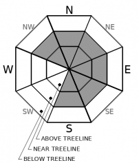
Strong SW winds throughout the storm have created large wind slabs on NW-N-NE-E-SE aspects in near and above treeline terrain.  Wind slabs will continue to build today with additional snow and strong winds.  Wind slabs will become possible on other aspects as winds shift to the NW and NE today and tonight.  Natural avalanches remain possible with human triggered wind slab avalanches likely.  These wind slab avalanches could run long distances into below treeline terrain.

Look for blowing snow, cornice formation, and wind pillows.  Avoid steep wind loaded terrain and runout zones below wind loaded slopes and large cornices.     

Avalanche Problem 2: Storm Slab
  • Type ?
  • Aspect/Elevation ?
  • Likelihood ?
    Certain
    Very Likely
    Likely
    Possible
    Unlikely
  • Size ?
    Historic
    Very Large
    Large
    Small

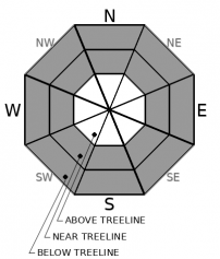
Storm slab avalanches will remain possible on all aspects in wind protected near and below treeline terrain.  Variations within the storm have deposited several different layers within the recent storm snow.  Continued cold temperatures will slow down the settlement process and may allow for storm slab instabilities to be problematic today.    

Look for cracking and/or any signs of cohesion of the recent storm snow.  In areas where storm slabs do not exist, loose dry sluffing may be encountered on steep slopes.  Some of these loose dry avalanches could be large enough to take a backcountry user for a ride into potential hazards or obstacles.  

recent observations

*  A small storm slab avalanche was reported on Incline Lake Peak (Mt. Rose area).  8800' on a NE aspect.

*  Shooting cracks along with active wind slab development was observed near the top of Rubicon Peak (West Shore area).

*  Widespread intense snow transport was observed throughout the forecast region by the recent SW winds.  Heavy snowfall rates up to 4''/hour were also observed.  Storm depths have been reported from 3 to 5' of snow above 7000'.  A variety of precipitation particles were seen including large amounts of graupel.


Weather and CURRENT CONDITIONS
weather summary

Periods of moderate to heavy snowfall will continue in the Sierra today.  Snow should pick up this morning and into the afternoon and be showery in nature.  Localized areas that benefit from lake effect snow or where these bands set up, could see much higher snowfall rates today.  The snow is expected to taper by this evening.  Monday and Tuesday should clear out and remain very cold with well below normal temperatures.  Next chance of a storm is midweek. 

CONDITIONS ALONG THE SIERRA CREST BETWEEN 8200 FT. AND 9200 FT. IN THE LAST 24 HOURS
6am temperature: 9 to 16 deg. F.
Max. temperature: 22 deg. F.
Average ridgetop wind direction: SW
Average ridgetop wind speed: 30 to 50 mph
Maximum ridgetop wind gust: 104 mph
New snowfall: 5 to 14 inches
Total snow depth: 121 to 131 inches
Two-Day Mountain Weather Forecast Produced in partnership with the Reno NWS
For 7000 ft. to 8000 ft.
Sunday Sunday Night Monday
Weather: Cloudy. Snow likely. Mostly cloudy. Snow showers likely in the evening then slight chance of snow showers after midnight. Mostly cloudy. Slight chance of snow in the morning.
Temperatures: 21 to 26 deg. F. 5 to 11 deg. F. 22 to 27 deg. F.
Mid Slope Winds: West 10 to 15mph NE around 10 with gusts to 25mph. NW around 10mph
Expected snowfall: 2 to 5" Up to 2'' Trace amounts
For 8000 ft. to 9000 ft.
Sunday Sunday Night Monday
Weather: Cloudy. Snow in the morning, then snow showers in the afternoon. Mostly cloudy. Snow showers in the evening, then chance of snow showers after midnight. Mostly cloudy. Slight chance of snow showers in the morning.
Temperatures: 16 to 22 deg. F. 3 to 8 deg. F. 15 to 21 deg. F.
Ridge Top Winds: NW 15 to 20mph. Gusts to 35mph decreasing to 25mph in the afternoon. NE 15 to 25mph with gusts to 40mph. N around 15 with gusts up to 30mph.
Expected snowfall: 3 to 6'' Up to 2'' Trace amounts
Disclaimer

This avalanche forecast is provided through a partnership between the Tahoe National Forest and the Sierra Avalanche Center. This forecast covers the Central Sierra Nevada Mountains between Yuba Pass on the north and Ebbetts Pass on the south. Click here for a map of the forecast area. This forecast applies only to backcountry areas outside established ski area boundaries. This forecast describes general avalanche conditions and local variations always occur. This forecast expires 24 hours after the posted time unless otherwise noted. The information in this forecast is provided by the USDA Forest Service who is solely responsible for its content.

For a recorded version of the avalanche forecast call (530) 587-3558 x258