THIS AVALANCHE FORECAST EXPIRED ON February 24, 2019 @ 6:45 am
Avalanche Forecast published on February 23, 2019 @ 6:45 am
Issued by Brandon Schwartz - Tahoe National Forest

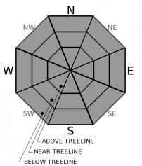
Avalanche danger is LOW for all elevations. Watch for isolated areas of wind slab instability if blowing and drifting snow is encountered.

1. Low

?

Above Treeline
Generally safe avalanche conditions. Watch for unstable snow on isolated terrain features.

1. Low

?

Near Treeline
Generally safe avalanche conditions. Watch for unstable snow on isolated terrain features.

1. Low

?

Below Treeline
Generally safe avalanche conditions. Watch for unstable snow on isolated terrain features.
    Generally safe avalanche conditions. Watch for unstable snow on isolated terrain features.
Avalanche Problem 1: Normal Caution
  • Type ?
  • Aspect/Elevation ?
  • Likelihood ?
    Certain
    Very Likely
    Likely
    Possible
    Unlikely
  • Size ?
    Historic
    Very Large
    Large
    Small

Ridgetop winds shifted back to the W but have remained too slow to drift significant amounts of snow. Forecast wind speeds for today are expected to move very little snow. If wind speeds remain as forecast today, no specific avalanche problem will exist and the ideas of normal caution will be appropriate.

Keep an eye out for areas of blowing and drifting snow. There is plenty of snow available for transport in ridgetop areas. If wind speed exceeds forecast amounts today, small wind slabs will form near treeline and above treeline on NW-N-NE-E-SE aspects where drifting snow is depositing. As SW wind speeds increase tomorrow, problematic wind slab development is likely.

Forecast discussion

Gradual warming today under the late February sun may allow for some minor warming instability, especially at the low and mid elevations. Expect to see some minor amounts of roller balls in sun exposed areas as snow falls off of rocks and trees. Problematic loose wet avalanches are not expected at this time.

recent observations

* Recent NE winds have scoured N-NE-E aspect terrain in near and above treeline areas. Plenty of snow is available in ridgetop areas for future wind transport by SW winds.

* Recent signs of instability below treeline have been isolated and limited to skier triggered surface sluffs in very steep/extreme terrain.

* The mid and bottom portions of the snowpack remain well bonded with instabilities limited to the upper portion of the snowpack.

Weather and CURRENT CONDITIONS
weather summary

Weak high pressure over the forecast area will move off to the east today. Cloud cover is expected to increase over the next 24 hours. Winds shifted to the west yesterday afternoon but have remained light to moderate in speed. A chance for light snowfall returns to the forecast tomorrow. Chances of precipitation increase Mon-Thurs with storm systems expected to impact the region.

CONDITIONS ALONG THE SIERRA CREST BETWEEN 8200 FT. AND 9200 FT. IN THE LAST 24 HOURS
6am temperature: 14 to 19 deg. F.
Max. temperature: 23 to 28 deg. F.
Average ridgetop wind direction: W
Average ridgetop wind speed: 18 mph
Maximum ridgetop wind gust: 32 mph
New snowfall: 0 inches
Total snow depth: 105 to 140 inches
Two-Day Mountain Weather Forecast Produced in partnership with the Reno NWS
For 7000 ft. to 8000 ft.
Saturday Saturday Night Sunday
Weather: Partly cloudy. Snow levels below 7000 feet. Chance of precipitation is 5%. Mostly cloudy. Slight chance of snow. Snow levels below 7000 feet. Chance of precipitation is 20%. Mostly cloudy. Slight chance of snow. Snow levels below 7000 feet. Chance of precipitation is 25%.
Temperatures: 30 to 35 deg. F. 18 to 23 deg. F. 32 to 37 deg. F.
Mid Slope Winds: Light winds becoming southwest around 15 mph with gusts up to 30 mph in the afternoon. Southwest 15 to 20 mph with gusts to 40 mph. Southwest 15 to 20 mph with gusts to 45 mph.
Expected snowfall: No accumulation. | SWE = none. 20% probability up to 1 inch. 80% probability up to 0 inches. | SWE = trace amounts. 20% probability up to 1 inch. 80% probability up to 0 inches. | SWE = less than 0.10 inch.
For 8000 ft. to 9000 ft.
Saturday Saturday Night Sunday
Weather: Partly cloudy. Snow levels below 7000 feet. Chance of precipitation is 5%. Mostly cloudy. Slight chance of snow after midnight. Snow levels below 7000 feet. Chance of precipitation is 20%. Mostly cloudy. Slight chance of snow. Snow levels below 7000 feet. Chance of precipitation is 20%.
Temperatures: 25 to 31 deg. F. 16 to 21 deg. F. 27 to 33 deg. F.
Ridge Top Winds: Southwest 15 to 20 mph with gusts to 35 mph. Southwest 15 to 25 mph with gusts to 40 mph. Southwest 20 to 30 mph with gusts to 50 mph.
Expected snowfall: No accumulation. | SWE = none. 20% probability up to 1 inch. 80% probability up to 0 inches. | SWE = less than 0.10 inch. 20% probability up to 1 inch. 80% probability up to 0 inches. | SWE = less than 0.10 inch.
Disclaimer

This avalanche forecast is provided through a partnership between the Tahoe National Forest and the Sierra Avalanche Center. This forecast covers the Central Sierra Nevada Mountains between Yuba Pass on the north and Ebbetts Pass on the south. Click here for a map of the forecast area. This forecast applies only to backcountry areas outside established ski area boundaries. This forecast describes general avalanche conditions and local variations always occur. This forecast expires 24 hours after the posted time unless otherwise noted. The information in this forecast is provided by the USDA Forest Service who is solely responsible for its content.

For a recorded version of the avalanche forecast call (530) 587-3558 x258