THIS AVALANCHE FORECAST EXPIRED ON February 25, 2019 @ 6:52 am
Avalanche Forecast published on February 24, 2019 @ 6:52 am
Issued by Steve Reynaud - Tahoe National Forest

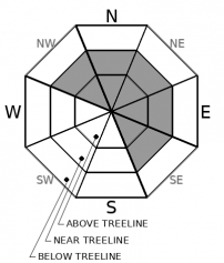
MODERATE avalanche danger will exist due to a wind slab avalanche problem in near and above treeline terrain.  Human triggered wind slab avalanches will be possible today.  Low avalanche danger will continue in below treeline areas.

2. Moderate

?

Above Treeline
Heightened avalanche conditions on specific terrain features. Evaluate snow and terrain carefully; identify features of concern.

2. Moderate

?

Near Treeline
Heightened avalanche conditions on specific terrain features. Evaluate snow and terrain carefully; identify features of concern.

1. Low

?

Below Treeline
Generally safe avalanche conditions. Watch for unstable snow on isolated terrain features.
    Heightened avalanche conditions on specific terrain features. Evaluate snow and terrain carefully; identify features of concern.
Avalanche Problem 1: Wind Slab
  • Type ?
  • Aspect/Elevation ?
  • Likelihood ?
    Certain
    Very Likely
    Likely
    Possible
    Unlikely
  • Size ?
    Historic
    Very Large
    Large
    Small

SW winds today will make wind slab avalanches possible on NW-N-NE-E-SE aspects in near and above treeline terrain.  SW winds have been on the increase since yesterday afternoon and are now in the strong to gale force range early this morning along exposed ridges and peaks.  Substantial snow is available for wind transport that is still soft due to the recent cold temperatures.  Wind slab avalanches are expected today and could be large enough to bury or injure a backcountry user.  Most of these wind slab avalanches should be human triggered, but isolated natural wind slab avalanches cannot be ruled out in the most heavily wind loaded areas.

Look for blowing snow, cornice formation, and newly formed wind pillows.  Intense snow transport is expected today.  Avoid steep wind loaded slopes and areas below large cornices.  Better snow quality will be found in protected below treeline terrain away from the wind slab avalanche problem.

recent observations

*  Increasing SW winds reported area wide with snow transport in the mid to late afternoon hours.  Substantial amounts of snow available for transport found along the northern Sierra crest above 8000'

*  Cold unconsolidated snow exists on northerly aspects in below and near treeline areas.

*  Observations were reported targeting the buried Feb 14 rain crust and previous sun crusts.  No location showed current instabilities, but something to continue to monitor. 

Weather and CURRENT CONDITIONS
weather summary

Strong SW winds are currently blowing along ridges and peaks ahead of our next storm moving into our region on Monday.  Mostly cloudy conditions with a small chance of light snow is forecasted for today.  A winter storm warning is in place for late Monday morning through late Wednesday morning.  Snow is expected on Monday with snow levels currently forecasted at 5000-6000'.  This storm has low forecaster confidence and snow totals and levels could change dramatically.  An active weather pattern continues through the week and into the weekend.  

CONDITIONS ALONG THE SIERRA CREST BETWEEN 8200 FT. AND 9200 FT. IN THE LAST 24 HOURS
6am temperature: 19 to 25 deg. F.
Max. temperature: 33 deg. F.
Average ridgetop wind direction: SW
Average ridgetop wind speed: 25 to 60 mph
Maximum ridgetop wind gust: 77 mph
New snowfall: 0 inches
Total snow depth: 103 to 136 inches
Two-Day Mountain Weather Forecast Produced in partnership with the Reno NWS
For 7000 ft. to 8000 ft.
Sunday Sunday Night Monday
Weather: Mostly cloudy. Slight chance of snow through the day. Snow levels below 7000 feet. Chance of precipitation is 20%. Mostly cloudy. Slight chance of snow through the night. Snow levels below 7000 feet. Chance of precipitation is 20%. Cloudy. Snow likely. Snow levels below 7000 feet. Chance of precipitation is 60%.
Temperatures: 32 to 37. deg. F. 22 to 27. deg. F. 33 to 38. deg. F.
Mid Slope Winds: Southwest 15 to 25 mph with gusts to 45 mph. Southwest 15 to 25 mph with gusts to 50 mph. Southwest 20 to 30 mph with gusts to 65 mph increasing to 30 to 40 mph with gusts to 85 mph in the afternoon.
Expected snowfall: No accumulation. | SWE = trace amounts. 20% probability up to 1 inch. 80% probability no accumulation. | SWE = less than 0.10 inch. 70% probability of 2 to 5 inches. 30% probability of 4 to 7 inches. | SWE = up to 0.30 inch.
For 8000 ft. to 9000 ft.
Sunday Sunday Night Monday
Weather: Mostly cloudy. Slight chance of snow through the day. Snow levels below 7000 feet. Chance of precipitation is 20%. Mostly cloudy. Slight chance of snow through the night. Snow levels below 7000 feet. Chance of precipitation is 20%. Cloudy. Snow likely. Snow levels below 7000 feet. Chance of precipitation is 55%.
Temperatures: 27 to 33. deg. F. 19 to 24. deg. F. 29 to 35. deg. F.
Ridge Top Winds: Southwest 20 to 35 mph with gusts to 55 mph. Southwest 30 to 45 mph with gusts to 75 mph. Southwest 40 to 60 mph with gusts to 95 mph.
Expected snowfall: No accumulation. | SWE = trace amounts. 20% probability up to 1 inch. 80% probability no accumulation. | SWE = trace amounts. 70% probability of 2 to 5 inches. 30% probability of 4 to 8 inches. | SWE = 0.15-0.25 inch.
Disclaimer

This avalanche forecast is provided through a partnership between the Tahoe National Forest and the Sierra Avalanche Center. This forecast covers the Central Sierra Nevada Mountains between Yuba Pass on the north and Ebbetts Pass on the south. Click here for a map of the forecast area. This forecast applies only to backcountry areas outside established ski area boundaries. This forecast describes general avalanche conditions and local variations always occur. This forecast expires 24 hours after the posted time unless otherwise noted. The information in this forecast is provided by the USDA Forest Service who is solely responsible for its content.

For a recorded version of the avalanche forecast call (530) 587-3558 x258