


For 7000 ft. to 8000 ft.
| Monday | Monday Night | Tuesday | |
|---|---|---|---|
| Weather: | Partly cloudy then becoming mostly cloudy. Chance of snow in the morning...then snow developing in the afternoon. Snow levels below 7000 feet. Chance of precipitation is 50% increasing to 90% in the afternoon. | Cloudy. Snow. Snow levels below 7000 feet. Chance of precipitation is 100%. | Cloudy. Snow. Snow levels below 7000 feet. Chance of precipitation is 100%. |
| Temperatures: | 31 to 37. deg. F. | 27 to 30. deg. F. | 32 to 37. deg. F. |
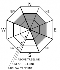
| Mid Slope Winds: | Southwest 15 to 30 mph with gusts to 45 mph increasing to 30 to 50 mph with gusts up to 70 mph in the afternoon. | Southwest 30 to 45 mph with gusts to 70 mph. | Southwest 30 to 45 mph with gusts to 75 mph. |
| Expected snowfall: | 70% probability of 2 to 5 inches. 30% probability of 1 to 2 inches. | SWE = up to 0.40 inch. | 80% probability of 10 to 17 inches. 20% probability of 17 to 24 inches. | SWE = up to 1.20 inches. | 70% probability of 8 to 14 inches. 30% probability of 14 to 18 inches. | SWE = up to 1.15 inches. |
For 8000 ft. to 9000 ft.
| Monday | Monday Night | Tuesday | |
|---|---|---|---|
| Weather: | Partly cloudy then becoming mostly cloudy. Chance of snow in the morning...then snow developing in the afternoon. Snow levels below 7000 feet. Chance of precipitation is 50% increasing to 90% in the afternoon. | Cloudy. Snow. Snow levels below 7000 feet. Chance of precipitation is 100%. | Cloudy. Snow. Snow levels below 7000 feet. Chance of precipitation is 100%. |
| Temperatures: | 25 to 31. deg. F. | 23 to 27. deg. F. | 27 to 32. deg. F. |
| Ridge Top Winds: | Southwest 45 to 75 mph with gusts to 115 mph. | Southwest 45 to 70 mph with gusts to 120 mph. | Southwest 45 to 70 mph with gusts to 115 mph. |
| Expected snowfall: | 70% probability of 3 to 5 inches. 30% probability of 1 to 3 inches. | SWE = up to 0.40 inch. | 70% probability of 12 to 18 inches. 30% probability of 18 to 25 inches. | SWE = 0.75-1.25 inches. | 70% probability of 11 to 18 inches. 30% probability of 18 to 25 inches. | SWE = 0.80-1.30 inches. |


