THIS AVALANCHE FORECAST EXPIRED ON March 1, 2019 @ 6:50 am
Avalanche Forecast published on February 28, 2019 @ 6:50 am
Issued by Brandon Schwartz - Tahoe National Forest

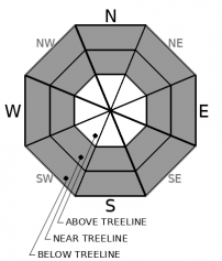
CONSIDERABLE avalanche danger exists at all elevations due to a combination of wind slab, storm slab, and loose wet avalanche problems. Human triggered avalanches should not be a surprise to backcountry travelers today.

3. Considerable

?

Above Treeline
Dangerous avalanche conditions. Careful snowpack evaluation, cautious route-finding and conservative decision-making essential.

3. Considerable

?

Near Treeline
Dangerous avalanche conditions. Careful snowpack evaluation, cautious route-finding and conservative decision-making essential.

3. Considerable

?

Below Treeline
Dangerous avalanche conditions. Careful snowpack evaluation, cautious route-finding and conservative decision-making essential.
    Dangerous avalanche conditions. Careful snowpack evaluation, cautious route-finding and conservative decision-making essential.
Avalanche Problem 1: Wind Slab
  • Type ?
  • Aspect/Elevation ?
  • Likelihood ?
    Certain
    Very Likely
    Likely
    Possible
    Unlikely
  • Size ?
    Historic
    Very Large
    Large
    Small

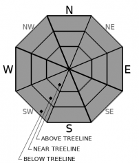
The wind slab avalanche problem continues today. In some cases wind slab avalanches occurred naturally, in other cases they have been difficult to trigger (stubborn). When avalanches have occurred over the past few days, size has mostly been D2 to D3. The vast majority of wind slabs exist near treeline and above treeline on NW-N-NE-E-SE aspects. Unstable wind slabs may be encountered to a more isolated extent on other aspects and below treeline due to the strength of the wind. Some of these wind slabs may take on some wet slab characteristics today in sun exposed areas.

Identify the problem areas to avoid. Use clues such as blowing snow, cornices, wind pillows, and snow surface texture to locate where unstable wind slabs are likely to exist. Move around these areas with a wide margin for error. Do not underestimate the avalanche size potential, potential width of propagation, or potential run out distance. Do not fall into the trap of making stability assessments based on previous tracks. Remember, triggering has been stubborn in some cases.

Avalanche Problem 2: Storm Slab
  • Type ?
  • Aspect/Elevation ?
  • Likelihood ?
    Certain
    Very Likely
    Likely
    Possible
    Unlikely
  • Size ?
    Historic
    Very Large
    Large
    Small

Additional snowfall last night with the highest snow levels of this event have kept the storm slab avalanche problem ongoing. The most recent new snow is upside-down providing slab over less dense snow below. Wind slabs may be encountered in wind protected below treeline to near treeline terrain on any aspect. Expected avalanche size is D1 to D2. Some of these storm slabs may take on some wet slab characteristics today in sun exposed areas.

Search for evidence of instability in the form of recent avalanches, snow surface cracking while breaking trail, or unstable snowpit test results. If instability exists, make conservative terrain and route choices both uphill and down.

Avalanche Problem 3: Loose Wet
  • Type ?
  • Aspect/Elevation ?
  • Likelihood ?
    Certain
    Very Likely
    Likely
    Possible
    Unlikely
  • Size ?
    Historic
    Very Large
    Large
    Small

It's nearly March and the associated higher sun angle and stronger solar radiation have crept in during the recent weeks of storms. As sun breaks occur today, expect roller ball and loose wet avalanche activity to occur just about anywhere. Avalanche size is not expected to exceed D1, so the consequences will come from terrain hazards such as being carried over cliffs or into terrain traps, rocks, trees, etc.

recent observations

* Additional reports of natural slab avalanches with crowns of 2 to 3 feet have been received. These avalanches occurred on a variety of aspects both above and below treeline. Avalanche size has been mostly D2 with at least one D3 reported that closed the railroad. In some cases, crowns have been 1/4 mile wide. Early indications are that two distinct natural avalanche cycles have occurred, one on the morning of Feb 26 and a second on the morning of Feb 27.

* Evidence of instability has been quite variable both spatially and temporally during this storm cycle with some parties encountering little evidence of instability despite the natural avalanche activity elsewhere.

* Tree bombing, rollerballs, and a few small (size D1) loose wet avalanches were noted yesterday, mainly at the lower elevations.

* Cornices are large, fragile, and breaking off easily.

Weather and CURRENT CONDITIONS
weather summary

The current storm system is winding down. Snow level peaked last night around 6,800'. Snow level is currently lowering slowly, forecast at 5,500' to 6,000' today. Snow showers are expected to taper off as the day progresses. Some sunshine is possible today during cloud breaks. Ridgetop winds continue out of the SW and have decreased some in speed but remain strong. A short lived break in the weather is expected later today through Friday. The next storm system is forecast to arrive late Friday night.

CONDITIONS ALONG THE SIERRA CREST BETWEEN 8200 FT. AND 9200 FT. IN THE LAST 24 HOURS
6am temperature: 24 to 29 deg. F.
Max. temperature: 28 to 33 deg. F.
Average ridgetop wind direction: SW
Average ridgetop wind speed: 64 mph
Maximum ridgetop wind gust: 110 mph
New snowfall: 7 to 11 inches
Total snow depth: 109 to 168 inches
Two-Day Mountain Weather Forecast Produced in partnership with the Reno NWS
For 7000 ft. to 8000 ft.
Thursday Thursday Night Friday
Weather: Mostly cloudy with snow showers tapering through the day. Snow levels below 7000 feet. Chance of precipitation is 75%. Mostly cloudy. Chance of snow through the night. Snow levels below 7000 feet. Chance of precipitation is 25%. Mostly cloudy then becoming partly cloudy. Slight chance of snow through the day. Snow levels below 7000 feet. Chance of precipitation is 20%.
Temperatures: 32 to 37 deg. F. 21 to 26 deg. F. 33 to 38 deg. F.
Mid Slope Winds: Southwest 15 to 30 mph with gusts to 60 mph. Southwest 15 to 30 mph. Gusts up to 60 mph decreasing to 45 mph after midnight. Southwest 15 to 25 mph. Gusts up to 40 mph increasing to 50 mph in the afternoon.
Expected snowfall: 80% probability of 2 to 5 inches. 20% probability of 5 to 8 inches. | SWE = up to 0.40 inch. Up to 2 inches. | SWE = less than 0.10 inch. Up to 1 inch. | SWE = less than 0.10 inch.
For 8000 ft. to 9000 ft.
Thursday Thursday Night Friday
Weather: Mostly cloudy with snow showers tapering through the day. Snow levels below 7000 feet. Chance of precipitation is 80%. Mostly cloudy. Chance of snow through the night. Snow levels below 7000 feet. Chance of precipitation is 30%. Mostly cloudy then becoming partly cloudy. Slight chance of snow through the day. Snow levels below 7000 feet. Chance of precipitation is 20%.
Temperatures: 28 to 34 deg. F. 17 to 22 deg. F. 29 to 35 deg. F.
Ridge Top Winds: Southwest 30 to 45 mph with gusts to 85 mph. Southwest 30 to 45 mph decreasing to 25 to 35 mph after midnight. Gusts up to 70 mph. Southwest 25 to 35 mph with gusts to 70 mph.
Expected snowfall: 80% probability of 3 to 6 inches. 20% probability of 6 to 9 inches. | SWE = 0.15-0.40 inch. Up to 2 inches. | SWE = less than 0.10 inch. Up to 1 inch. | SWE = less than 0.10 inch.
Disclaimer

This avalanche forecast is provided through a partnership between the Tahoe National Forest and the Sierra Avalanche Center. This forecast covers the Central Sierra Nevada Mountains between Yuba Pass on the north and Ebbetts Pass on the south. Click here for a map of the forecast area. This forecast applies only to backcountry areas outside established ski area boundaries. This forecast describes general avalanche conditions and local variations always occur. This forecast expires 24 hours after the posted time unless otherwise noted. The information in this forecast is provided by the USDA Forest Service who is solely responsible for its content.

For a recorded version of the avalanche forecast call (530) 587-3558 x258