THIS AVALANCHE FORECAST EXPIRED ON February 5, 2019 @ 6:50 am
Avalanche Forecast published on February 4, 2019 @ 6:50 am
Issued by Steve Reynaud - Tahoe National Forest

HIGH avalanche danger will continue as a powerful winter storm impacts our forecast area today and through tonight.  Very dangerous avalanche conditions will exist.  Travel in, near, or below avalanche terrain is not recommended.

4. High

?

Above Treeline
Very dangerous avalanche conditions. Travel in avalanche terrain not recommended.

4. High

?

Near Treeline
Very dangerous avalanche conditions. Travel in avalanche terrain not recommended.

4. High

?

Below Treeline
Very dangerous avalanche conditions. Travel in avalanche terrain not recommended.
    Very dangerous avalanche conditions. Travel in avalanche terrain not recommended.
Avalanche Problem 1: Wind Slab
  • Type ?
  • Aspect/Elevation ?
  • Likelihood ?
    Certain
    Very Likely
    Likely
    Possible
    Unlikely
  • Size ?
    Historic
    Very Large
    Large
    Small

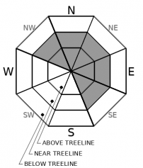
Gale force SW winds along with additional snow today and tonight will add to existing fragile wind slabs and cornices from yesterday.  Large and destructive wind slab avalanches will be very likely on NW-N-NE-E-SE aspects in near and above treeline terrain.  Wind slabs could also form on other aspects and in below treeline areas due to the elevated SW wind speeds.  Large wind slab avalanches could occur naturally and travel far distances down into mature forests.  Travel in, near, or below avalanche terrain is not advised. 

Avalanche Problem 2: Storm Slab
  • Type ?
  • Aspect/Elevation ?
  • Likelihood ?
    Certain
    Very Likely
    Likely
    Possible
    Unlikely
  • Size ?
    Historic
    Very Large
    Large
    Small

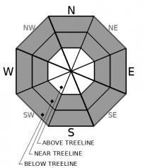
Storm slab avalanches will be very likely on all aspects in near and below treeline terrain.  High intensity snowfall rates of 3''/hour or more are forecasted during this storm today and tonight.  Weaknesses could develop within the new storm snow today or snow that fell during the last 2 days.  Avalanches that involved deeper layers in the storm snow, or the potentially buried surface hoar layer, would be much larger in size and have severe consequences.  Large and destructive storm slab avalanches that occur naturally could run long distances through mature forests.  Travel in, below, or near avalanche terrain is not recommended.

recent observations

*  Storm slab and wind slab avalanches were reported from Incline Lake Peak (Mt. Rose area).  Widespread instabilities were noted with large shooting cracks and wind transport.  Storm slab avalanches up to size D2 were reported from ski cuts.

Wind slab avalanches were easily triggered on small test slopes on Tamarack Peak (Mt. Rose area).  Large shooting cracks, intense wind transport, with limited visibility was observed.

*  Other signs of instability were reported from Shirley Canyon (Squaw Valley area), Powderhouse (Luther Pass area), and Meadow Lake (Independence Lake area).  Moderate to intense snow transport, shooting cracks, and wind slab development were all observed.  Some protected below treeline areas showed little signs of instabilities.

Weather and CURRENT CONDITIONS
weather summary

A major pacific storm will bring heavy snow and gale force SW winds to our forecast area today and through tonight.  Storm totals above 7000' along the Sierra Crest range from 2 to 3'+ up to this point.  For today, multiple feet of snow is possible above 7000' with 1-2' possible at lake level.  Snow levels should continue to lower with snow reaching lower valley floors down to around 4000'.  Full white out blizzard conditions could occur throughout today and tonight.  Snowfall rates are forecasted to be 3''/hour + at times.  Additional snowfall is expected through Tuesday before a break on Wednesday.

CONDITIONS ALONG THE SIERRA CREST BETWEEN 8200 FT. AND 9200 FT. IN THE LAST 24 HOURS
6am temperature: 19 to 23 deg. F.
Max. temperature: 30 deg. F.
Average ridgetop wind direction: SW
Average ridgetop wind speed: 40 to 75 mph
Maximum ridgetop wind gust: 107 mph
New snowfall: 8 to 18 inches
Total snow depth: 86 to 109 inches
Two-Day Mountain Weather Forecast Produced in partnership with the Reno NWS
For 7000 ft. to 8000 ft.
Monday Monday Night Tuesday
Weather: Cloudy. Snow. Snow levels below 7000 feet. Chance of precipitation is 100%. Cloudy. Snow. Snow levels below 7000 feet. Chance of precipitation is 95%. Cloudy. Snow. Snow levels below 7000 feet. Chance of precipitation is 90%.
Temperatures: 24 to 29. deg. F. 10 to 16. deg. F. 17 to 22. deg. F.
Mid Slope Winds: Southwest 20 to 35 mph with gusts to 65 mph. Southwest 15 to 30 mph. Gusts up to 55 mph decreasing to 45 mph after midnight. Southwest 10 to 15 mph with gusts to 30 mph.
Expected snowfall: 70% probability of 14 to 22 inches. 30% probability of 22 to 30 inches. | SWE = 0.75-1.25 inches. 70% probability of 9 to 15 inches. 30% probability of 15 to 20 inches. | SWE = 0.55-0.80 inch. 80% probability of 3 to 7 inches. 20% probability of 7 to 10 inches. | SWE = 0.20-0.40 inch.
For 8000 ft. to 9000 ft.
Monday Monday Night Tuesday
Weather: Cloudy. Snow. Snow levels below 7000 feet. Chance of precipitation is 100%. Cloudy. Snow. Snow levels below 7000 feet. Chance of precipitation is 95%. Cloudy. Snow. Snow levels below 7000 feet. Chance of precipitation is 90%.
Temperatures: 21 to 26. deg. F. 8 to 13. deg. F. 12 to 17. deg. F.
Ridge Top Winds: Southwest 30 to 50 mph with gusts to 105 mph. Southwest 30 to 45 mph decreasing to 25 to 35 mph after midnight. Gusts up to 90 mph. Southwest 15 to 25 mph. Gusts up to 60 mph decreasing to 40 mph in the afternoon.
Expected snowfall: 70% probability of 16 to 24 inches. 30% probability of 24 to 36 inches. | SWE = 0.85-1.35 inches. 70% probability of 10 to 18 inches. 30% probability of 18 to 26 inches. | SWE = 0.60-0.85 inch. 80% probability of 4 to 8 inches. 20% probability of 9 to 15 inches. | SWE = 0.20-0.45 inch.
Disclaimer

This avalanche forecast is provided through a partnership between the Tahoe National Forest and the Sierra Avalanche Center. This forecast covers the Central Sierra Nevada Mountains between Yuba Pass on the north and Ebbetts Pass on the south. Click here for a map of the forecast area. This forecast applies only to backcountry areas outside established ski area boundaries. This forecast describes general avalanche conditions and local variations always occur. This forecast expires 24 hours after the posted time unless otherwise noted. The information in this forecast is provided by the USDA Forest Service who is solely responsible for its content.

For a recorded version of the avalanche forecast call (530) 587-3558 x258