THIS AVALANCHE FORECAST EXPIRED ON January 13, 2019 @ 6:58 am
Avalanche Forecast published on January 12, 2019 @ 6:58 am
Issued by Brandon Schwartz - Tahoe National Forest

Avalanche danger has been elevated from yesterday's LOW danger back up to MODERATE danger for today at all elevations due to uncertainty associated with a lingering persistent slab avalanche problem. Large destructive avalanches are possible again today, mainly in response to large triggers.

2. Moderate

?

Above Treeline
Heightened avalanche conditions on specific terrain features. Evaluate snow and terrain carefully; identify features of concern.

2. Moderate

?

Near Treeline
Heightened avalanche conditions on specific terrain features. Evaluate snow and terrain carefully; identify features of concern.

2. Moderate

?

Below Treeline
Heightened avalanche conditions on specific terrain features. Evaluate snow and terrain carefully; identify features of concern.
    Heightened avalanche conditions on specific terrain features. Evaluate snow and terrain carefully; identify features of concern.
Avalanche Problem 1: Persistent Slab
  • Type ?
  • Aspect/Elevation ?
  • Likelihood ?
    Certain
    Very Likely
    Likely
    Possible
    Unlikely
  • Size ?
    Historic
    Very Large
    Large
    Small

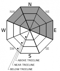
A lingering persistent slab avalanche problem exists above and below treeline on NW-N-NE-E aspects. Getting force down to the buried weak layers of faceted snow is difficult, generally requiring large triggers such as cornice collapse. The slope on the north side of Castle Peak where a large avalanche occurred yesterday had numerous tracks on it prior to avalanching in response to a large cornice collapse. Any persistent slab avalanches that occur today will be large and possibly destructive at size D2 to D3 (large enough to bury or injure a person up to large enough to bury and destroy a car, damage a truck, destroy small buildings, or break a few trees).

From a travel advice standpoint, this avalanche problem is very challenging. Finding evidence of instability on a specific slope prior to an avalanche occurring is not easy to gather. Previous tracks are not an indication of stability, rather just that the trigger was either not large enough or not in the exact right spot on the slope to create an avalanche. Snowpit tests can produce false stable results with the current setup of deep weak layers and dense overlying snow. Choosing simple terrain without rocks and cliffs that is not capable of producing large avalanches and giving yourself a wide margin for error is a good choice for today.


Forecast discussion

SAC forecasters use the Conceptual Model of Avalanche Hazard (Statham et al, 2017) as guidance for selecting the danger rating. "Likelihood of triggering" combined with the avalanche problem leads to the danger rating. Likelihood of triggering is derived from a combination of "sensitivity to triggering" (unreactive, stubborn, reactive, touchy) and "spatial distribution" in terrain (isolated, specific, widespread). In the current case of our lingering persistent slab problem, sensitivity to triggering is clearly stubborn. Uncertainty exists for spatial distribution whether it is isolated or specific terrain at this time. Stubborn with isolated leads to unlikely triggering in the model. Stubborn with specific terrain leads to possible triggering in the model. This puts the current regional scale avalanche danger somewhere in the LOW to MODERATE range, even though the large avalanche size creates larger consequences when an avalanche does occur. On a regional scale across the forecast area, the number of avalanches occurring in relation to the number of people traveling in avalanche terrain over the past few days is minimal.

recent observations

* A large persistent slab avalanche was triggered yesterday on the north side of Castle Peak at 8,600' by human triggered collapse of a small car-sized cornice. There were numerous ski, snowboard, and snowmobile tracks all over the area, including on the specific slope before the avalanche occurred.

* Reports were received of other large human triggered cornice collapses that did not trigger avalanches on NW aspect terrain from the Broncho Chutes on Relay Peak (Mount Rose area) and from NE aspect terrain on Little Alaska near Twin Peaks (Ward Canyon area).

* Recent snowpit data from along the Sierra Crest has indicated improving stability on the weak layers of faceted snow deeply buried below the Jan 5-7 storm snow. All available data indicates this problem is difficult to trigger (stubborn) and requires large triggers to create avalanches.

* A small (size D1) wind slab avalanche with a 6 inch crown was triggered by a snowboarder yesterday on the north side of Castle Peak.

* Snowpit data and other observations have indicated an absence of the persistent slab problem in the Mount Rose area.

Weather and CURRENT CONDITIONS
weather summary

Decreasing cloud cover and light ridgetop winds are expected today. Quiet weather will last through Sunday with an increase in ridgetop wind speeds. The potential for light snowfall returns to the forecast area late Sunday night. A major storm system is forecast for the Tuesday-Thursday timeframe. Check with NWS Reno for details on the upcoming storm cycle.

CONDITIONS ALONG THE SIERRA CREST BETWEEN 8200 FT. AND 9200 FT. IN THE LAST 24 HOURS
6am temperature: 21 to 29 deg. F.
Max. temperature: 33 to 43 deg. F.
Average ridgetop wind direction: SE
Average ridgetop wind speed: 12 mph
Maximum ridgetop wind gust: 33 mph
New snowfall: 0 inches
Total snow depth: 46 to 53 inches
Two-Day Mountain Weather Forecast Produced in partnership with the Reno NWS
For 7000 ft. to 8000 ft.
Saturday Saturday Night Sunday
Weather: Mostly cloudy then becoming partly cloudy. Snow levels below 7000 feet. Chance of precipitation is 0%. Clear. Snow levels below 7000 feet. Chance of precipitation is 0%. Sunny. Snow levels below 7000 feet. Chance of precipitation is 0%.
Temperatures: 34 to 39. deg. F. 17 to 23. deg. F. 31 to 37. deg. F.
Mid Slope Winds: East around 10 mph. East around 10 mph. East around 10 mph.
Expected snowfall: No accumulation. | SWE = none. No accumulation. | SWE = none. No accumulation. | SWE = none.
For 8000 ft. to 9000 ft.
Saturday Saturday Night Sunday
Weather: Mostly cloudy then becoming partly cloudy. Snow levels below 7000 feet. Chance of precipitation is 0%. Clear. Snow levels below 7000 feet. Chance of precipitation is 0%. Sunny. Snow levels below 7000 feet. Chance of precipitation is 5%.
Temperatures: 31 to 37. deg. F. 15 to 20. deg. F. 28 to 34. deg. F.
Ridge Top Winds: East 10 to 20 mph. East 15 to 25 mph. Gusts up to 30 mph increasing to 40 mph after midnight. Southeast 15 to 25 mph with gusts to 35 mph.
Expected snowfall: No accumulation. | SWE = none. No accumulation. | SWE = none. No accumulation. | SWE = none.
Disclaimer

This avalanche forecast is provided through a partnership between the Tahoe National Forest and the Sierra Avalanche Center. This forecast covers the Central Sierra Nevada Mountains between Yuba Pass on the north and Ebbetts Pass on the south. Click here for a map of the forecast area. This forecast applies only to backcountry areas outside established ski area boundaries. This forecast describes general avalanche conditions and local variations always occur. This forecast expires 24 hours after the posted time unless otherwise noted. The information in this forecast is provided by the USDA Forest Service who is solely responsible for its content.

For a recorded version of the avalanche forecast call (530) 587-3558 x258