THIS AVALANCHE FORECAST EXPIRED ON January 18, 2019 @ 6:59 am
Avalanche Forecast published on January 17, 2019 @ 6:59 am
Issued by Andy Anderson - Tahoe National Forest - Sierra Avalanche Center

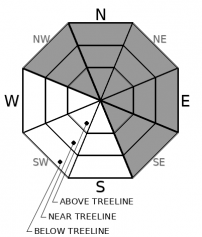
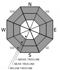
HIGH avalanche danger exists at all elevations. Widespread, large destructive natural avalanche activity is likely and human-triggered avalanches are very likely. Very dangerous and complex avalanche conditions continue due to a mix of wind slabs, storm slabs, and deep persistent slabs. Travel in, below, or near avalanche terrain is not recommended.

4. High

?

Above Treeline
Very dangerous avalanche conditions. Travel in avalanche terrain not recommended.

4. High

?

Near Treeline
Very dangerous avalanche conditions. Travel in avalanche terrain not recommended.

4. High

?

Below Treeline
Very dangerous avalanche conditions. Travel in avalanche terrain not recommended.
    Very dangerous avalanche conditions. Travel in avalanche terrain not recommended.
Avalanche Problem 1: Wind Slab
  • Type ?
  • Aspect/Elevation ?
  • Likelihood ?
    Certain
    Very Likely
    Likely
    Possible
    Unlikely
  • Size ?
    Historic
    Very Large
    Large
    Small

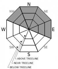
Fragile wind slabs have formed on wind-loaded slopes. Wind slabs could exist at any elevation including in some below treeline areas. The largest wind slabs should reside in near and above treeline terrain on NW-N-NE-E-SE aspects. Large and destructive wind slab avalanches are very likely today. Remote triggering is possible, avalanches could propagate wider than normal or even across connected slopes, and wind slab avalanches could run farther downslope than expected especially in areas where the wind slabs may rest on buried surface hoar. Wind slabs will continue to become larger and more widespread during this storm. 

Avalanche Problem 2: Storm Slab
  • Type ?
  • Aspect/Elevation ?
  • Likelihood ?
    Certain
    Very Likely
    Likely
    Possible
    Unlikely
  • Size ?
    Historic
    Very Large
    Large
    Small

Large storm slab avalanches are also very likely today. Rapid loading from 2-3 in/hr snowfall rates could easily cause a failure in the storm snow weaknesses, the upside-down layering, and/or the buried surface hoar layer at the base of the storm snow. Storm slab avalanches could occur on any slopes steep enough to avalanche including in areas typically thought of as safe like tree-covered slopes or lower elevation slopes. Storm slabs could fracture wider and deeper than expected and be remotely triggered. Like the wind slabs mentioned above, they will become more widespread and larger as more snow accumulates. 

Avalanche Problem 3: Deep Slab
  • Type ?
  • Aspect/Elevation ?
  • Likelihood ?
    Certain
    Very Likely
    Likely
    Possible
    Unlikely
  • Size ?
    Historic
    Very Large
    Large
    Small

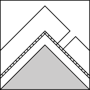
Deep slab avalanches could occur today as well due to the additional weight of several feet of new snow overloading the old persistent weak layers buried several feet below the surface. Smaller triggers in the right places like a person on a trigger point or larger triggers like the weight of the new snow, cornice collapses, or other avalanches could cause a deep slab to release. If a deep slab avalanche does occur, it would be large, destructive, and unsurvivable. More snow today will make deep slab avalanches more likely.

recent observations

* Observers reported numerous natural avalanches capable of burying a person or even a car on Incline Lake Peak, Tamarack Peak, and along Hwy 89 north of Tahoe City. 

* Remotely triggered avalanches big enough to bury a person or car were reported from Elephant's Hump and Slide Mountain. Another group remotely triggered a test slope north of Basin Peak. The people who triggered these were between 10 and 100 ft away from the avalanches

* Many of these avalanches likely failed on buried surface hoar.

* Observers on Luther Pass, in Ward Canyon, in the Mt. Rose backcountry, on the West Shore, on Brockway Summit, in areas north of Donner Summit, and in the Carson Pass backcountry all experienced shooting cracks, found an upside-down snowpack, and saw active wind loading. Most also had test slope failures in wind slabs and storm slabs and found buried surface hoar along with unstable snowpit test results on the surface hoar and other storm snow layers. 

Weather and CURRENT CONDITIONS
weather summary

Another 2 to 4 inches of water fell from the sky in the last 24 hours. Snow levels seemed to hover around 6500 to 7000 ft yesterday and may have reached as high as 7500 ft in a few areas. Above 7000 ft most of the precipitation fell as heavy wet snow. Remote sensors are showing 1 to 2 ft of new snow in the last 24 hours. Hurricane force ridge top winds have accompanied this storm. Temperatures started to fall around 2 am and should continue decreasing today. Expect snow levels to drop below 6000 ft. Violent southwest winds and heavy snow should continue through tonight with another 2 to 3 ft of new snow above 7000 ft and 1 to 2 ft down to 6000 ft by tomorrow morning. For more updates on this blizzard check in with the Reno NWS.

CONDITIONS ALONG THE SIERRA CREST BETWEEN 8200 FT. AND 9200 FT. IN THE LAST 24 HOURS
6am temperature: 24 to 30 deg. F.
Max. temperature: 29 to 34 deg. F.
Average ridgetop wind direction: Southwest
Average ridgetop wind speed: 70 to 80 mph
Maximum ridgetop wind gust: 138 mph
New snowfall: 10 to 24 inches
Total snow depth: 72 to 88 inches
Two-Day Mountain Weather Forecast Produced in partnership with the Reno NWS
For 7000 ft. to 8000 ft.
Thursday Thursday Night Friday
Weather: Cloudy. Widespread snow showers. Snow levels below 7000 feet. Chance of precipitation is 100%. Cloudy. Widespread snow showers in the evening, then chance of snow showers after midnight. Snow levels below 7000 feet. Chance of precipitation is 90%. Mostly cloudy. Chance of snow through the day. Snow levels below 7000 feet. Chance of precipitation is 30%.
Temperatures: 27 to 32 deg. F. 18 to 24 deg. F. 32 to 37 deg. F.
Mid Slope Winds: Southwest 20 to 35 mph with gusts to 60 mph. Southwest 15 to 30 mph. Gusts up to 45 mph. Southwest 10 to 15 mph with gusts to 25 mph in the morning becoming light.
Expected snowfall: 80% probability of 12 to 20 inches. 20% probability of 20 to 30 inches. | SWE = 0.90-1.35 inches. 80% probability of 3 to 7 inches. 20% probability of 7 to 12 inches. | SWE = up to 0.40 inch. 100% probability up to 1 inch. | SWE = less than 0.10 inch.
For 8000 ft. to 9000 ft.
Thursday Thursday Night Friday
Weather: Cloudy. Widespread snow showers. Snow levels below 7000 feet. Chance of precipitation is 100%. Cloudy. Widespread snow showers in the evening, then chance of snow showers after midnight. Snow levels below 7000 feet. Chance of precipitation is 85%. Mostly cloudy. Chance of snow through the day. Snow levels below 7000 feet. Chance of precipitation is 30%.
Temperatures: 22 to 28 deg. F. 16 to 21 deg. F. 28 to 34 deg. F.
Ridge Top Winds: Southwest 40 to 60 mph with gusts to 130 mph. Southwest 30 to 50 mph with gusts to 100 mph. West 30 to 45 mph with gusts to 80 mph.
Expected snowfall: 80% probability of 15 to 24 inches. 20% probability of 22 to 32 inches. | SWE = 1.00-1.50 inches. 80% probability of 3 to 7 inches. 20% probability of 7 to 12 inches. | SWE = 0.25-0.50 inch. 100% probability up to 1 inch. | SWE = less than 0.10 inch.
Disclaimer

This avalanche forecast is provided through a partnership between the Tahoe National Forest and the Sierra Avalanche Center. This forecast covers the Central Sierra Nevada Mountains between Yuba Pass on the north and Ebbetts Pass on the south. Click here for a map of the forecast area. This forecast applies only to backcountry areas outside established ski area boundaries. This forecast describes general avalanche conditions and local variations always occur. This forecast expires 24 hours after the posted time unless otherwise noted. The information in this forecast is provided by the USDA Forest Service who is solely responsible for its content.

For a recorded version of the avalanche forecast call (530) 587-3558 x258