THIS AVALANCHE FORECAST EXPIRED ON January 20, 2019 @ 6:53 am
Avalanche Forecast published on January 19, 2019 @ 6:53 am
Issued by Brandon Schwartz - Tahoe National Forest

MODERATE avalanche danger exists at all elevations due to lingering wind slab and deep slab avalanche problems. Large destructive slab avalanches remain possible in isolated areas. Small loose wet avalanches may occur today in steep terrain.

2. Moderate

?

Above Treeline
Heightened avalanche conditions on specific terrain features. Evaluate snow and terrain carefully; identify features of concern.

2. Moderate

?

Near Treeline
Heightened avalanche conditions on specific terrain features. Evaluate snow and terrain carefully; identify features of concern.

2. Moderate

?

Below Treeline
Heightened avalanche conditions on specific terrain features. Evaluate snow and terrain carefully; identify features of concern.
    Heightened avalanche conditions on specific terrain features. Evaluate snow and terrain carefully; identify features of concern.
Avalanche Problem 1: Wind Slab
  • Type ?
  • Aspect/Elevation ?
  • Likelihood ?
    Certain
    Very Likely
    Likely
    Possible
    Unlikely
  • Size ?
    Historic
    Very Large
    Large
    Small

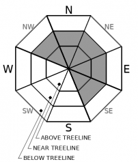
Lingering instability of wind slabs continues near treeline and above treeline on NW-N-NE-E-SE aspects. Large triggers such as natural or human triggered cornice collapse are the most likely way for avalanches to occur today. Large overhanging cornices were fairly weak yesterday and may remain so today. Avalanche size up to D2 is possible (large enough to bury or injure a person).

Keep a wide margin of safety on slopes below or adjacent to cornice features or wind pillows. Stay well back from overhung cornice edges along ridgelines.

Avalanche Problem 2: Deep Slab
  • Type ?
  • Aspect/Elevation ?
  • Likelihood ?
    Certain
    Very Likely
    Likely
    Possible
    Unlikely
  • Size ?
    Historic
    Very Large
    Large
    Small

Lingering avalanche concerns associated with deeply buried surface hoar and crust/facet layers have now been combined into a single deep slab avalanche problem as the travel management has become the same. In most areas, these weak layers exist 4 to 6+ feet deep in the snowpack but can be found a shallow as 2 feet deep in some areas. Weak layers associated with this avalanche problem are found both above and below treeline on NW-N-NE-E aspects. Triggering is difficult but consequences are big with large destructive avalanches up to size D4 possible (large enough to destroy a railway car or several buildings).

Conservative terrain choices are the way to go here in order to manage deep slab uncertainty. Slope scale stability evaluation is difficult as the weak layers are hard to assess so deep in the snowpack. Snowpit tests can give false positive results on deep layers. Previous tracks give no stability indications when dealing with deep slabs. Deep slab avalanches often occur on slopes with numerous previous tracks on them. Choose simple terrain that is not capable of producing large avalanches. Avoid complex terrain around rocks and cliffs and slopes with adjacent avalanche paths that share a runout zone.

Avalanche Problem 3: Loose Wet
  • Type ?
  • Aspect/Elevation ?
  • Likelihood ?
    Certain
    Very Likely
    Likely
    Possible
    Unlikely
  • Size ?
    Historic
    Very Large
    Large
    Small

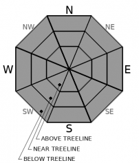
Small loose wet avalanches may occur today in steep terrain on any aspect at any elevation. Use roller balls as a clue for the presence of this instability. Avalanche size is expected to be too small to bury a person (size D1).

recent observations

* Foggy conditions yesterday morning turning to light rain below 9,000' to 9,500' will have wetted the snow surface in most locations.

* Wind slabs less than one foot deep were noted in several locations yesterday. Triggering was stubborn with small avalanches triggered by cornice collapse.

* Buried surface hoar was noted 2 feet below the snow surface on Carson Pass and 4.5 feet below the snow surface on Incline Lake Peak (Mount Rose area). In both locations, snowpit tests indicated that this layer was difficult to collapse, but still capable of propagation.

Weather and CURRENT CONDITIONS
weather summary

Warm air advection moved into the forecast area yesterday afternoon raising snow levels up to 9,000' to 9,500' last night. Light rain has fallen on all but the highest elevations. Drying and clearing conditions are expected today for most of the forecast area with continued light rain showers possible from about I-80 northward. Another storm system moves into the forecast area on Sunday with snow level forecast to gradually lower to 3,000' by the afternoon/evening. Total precipitation of 0.75 to 2 inches of SWE is forecast for Sunday/Sunday night with snowfall accumulation dependent on how quickly snow level lowers. Ridgetop winds remain out of the SW with moderate speeds today increasing to gale force tonight and tomorrow.

CONDITIONS ALONG THE SIERRA CREST BETWEEN 8200 FT. AND 9200 FT. IN THE LAST 24 HOURS
6am temperature: 32 to 35 deg. F.
Max. temperature: 32 to 35 deg. F.
Average ridgetop wind direction: SW
Average ridgetop wind speed: 45 mph
Maximum ridgetop wind gust: 67 mph
New snowfall: Snow 0 to 1 in. | Rain 0.1 to 0.5 inches
Total snow depth: 67 to 90 inches
Two-Day Mountain Weather Forecast Produced in partnership with the Reno NWS
For 7000 ft. to 8000 ft.
Saturday Saturday Night Sunday
Weather: Mostly cloudy skies becoming partly cloudy. Slight chance of rain in the morning. Snow levels 9000 feet. Chance of precipitation is 20%. Partly cloudy. Slight chance of rain and snow after midnight. Snow levels 7500 feet decreasing to below 7000 feet after midnight. Chance of precipitation is 10%. Cloudy. Chance of rain and snow through the morning. Snow in the afternoon. Snow levels 7000 feet. Chance of precipitation is 95%.
Temperatures: 39 to 44. deg. F. 27 to 32. deg. F. 36 to 41. deg. F.
Mid Slope Winds: Southwest 10 to 15 mph with gusts to 35 mph. Southwest 10 to 15 mph. Gusts up to 35 mph increasing to 45 mph after midnight. Southwest 20 to 30 mph increasing to 25 to 40 mph in the afternoon. Gusts up to 80 mph.
Expected snowfall: No accumulation. | SWE = less than 0.10 inch. No accumulation. 90% probability no accumulation. | SWE = none. 70% probability of 2 to 6 inches. 30% probability of 6 to 10 inches. | SWE = up to 0.70 inch.
For 8000 ft. to 9000 ft.
Saturday Saturday Night Sunday
Weather: Mostly cloudy then becoming partly cloudy. Slight chance of rain and snow in the morning. Snow levels 9000 feet. Chance of precipitation is 20%. Partly cloudy. Snow levels 7500 feet decreasing to below 7000 feet after midnight. Chance of precipitation is 10%. Mostly cloudy. Snow likely. Snow levels 7000 feet. Chance of precipitation is 95%.
Temperatures: 36 to 42. deg. F. 25 to 30. deg. F. 31 to 36. deg. F.
Ridge Top Winds: Southwest 15 to 30 mph. Gusts up to 55 mph decreasing to 45 mph in the afternoon. Southwest 20 to 35 mph. Gusts up to 50 mph increasing to 70 mph after midnight. Southwest 35 to 55 mph with gusts to 90 mph.
Expected snowfall: Up to 1 inch. | SWE = trace amounts. No accumulation. 90% probability no accumulation. | SWE = none. 70% probability of 4 to 8 inches. 30% probability of 8 to 12 inches. | SWE = up to 0.70 inch.
Disclaimer

This avalanche forecast is provided through a partnership between the Tahoe National Forest and the Sierra Avalanche Center. This forecast covers the Central Sierra Nevada Mountains between Yuba Pass on the north and Ebbetts Pass on the south. Click here for a map of the forecast area. This forecast applies only to backcountry areas outside established ski area boundaries. This forecast describes general avalanche conditions and local variations always occur. This forecast expires 24 hours after the posted time unless otherwise noted. The information in this forecast is provided by the USDA Forest Service who is solely responsible for its content.

For a recorded version of the avalanche forecast call (530) 587-3558 x258