THIS AVALANCHE FORECAST EXPIRED ON January 21, 2019 @ 6:58 am
Avalanche Forecast published on January 20, 2019 @ 6:58 am
Issued by Steve Reynaud - Tahoe National Forest

CONSIDERABLE avalanche danger will exist through the morning and into the afternoon due to wind slab, storm slab, and deep slab avalanche problems.  As the storm intensifies this afternoon, avalanche danger will rise to HIGH and continue overnight.  Dangerous avalanche conditions will exist with large and destructive avalanches possible.  Travel in avalanche terrain is not recommended.

4. High

?

Above Treeline
Very dangerous avalanche conditions. Travel in avalanche terrain not recommended.

4. High

?

Near Treeline
Very dangerous avalanche conditions. Travel in avalanche terrain not recommended.

4. High

?

Below Treeline
Very dangerous avalanche conditions. Travel in avalanche terrain not recommended.
    Very dangerous avalanche conditions. Travel in avalanche terrain not recommended.
Avalanche Problem 1: Wind Slab
  • Type ?
  • Aspect/Elevation ?
  • Likelihood ?
    Certain
    Very Likely
    Likely
    Possible
    Unlikely
  • Size ?
    Historic
    Very Large
    Large
    Small

Snow this morning with gale force SW winds will quickly form new wind slabs on NW-N-NE-E-SE aspects in near and above treeline terrain.  These wind slabs will form above the rain/snow line which could be as high as 7500-8000' initially before snow levels drop sometime this afternoon.  Widespread natural wind slab avalanches will become very likely this afternoon and through the night. 

Look for blowing snow, cornice formation, and wind pillows as clues to where wind slabs exists.  Avoid steep wind loaded terrain and areas below large cornices

Avalanche Problem 2: Storm Slab
  • Type ?
  • Aspect/Elevation ?
  • Likelihood ?
    Certain
    Very Likely
    Likely
    Possible
    Unlikely
  • Size ?
    Historic
    Very Large
    Large
    Small

Storm slabs will be likely on all aspects in near treeline and below treeline terrain.  Initially, these storm slabs may have wet slab and/or loose wet characteristics mainly below 8000' due to heavy rain on snow today.  As the storm intensifies this afternoon and snow levels drop, storm slabs from high intensity snowfall will become likely.  Storm slabs will continue to grow larger as this storm has the potential for 2' of snow by Monday morning along the Sierra Crest.  Natural storm slab avalanches will be likely today and tonight.


Avalanche Problem 3: Deep Slab
  • Type ?
  • Aspect/Elevation ?
  • Likelihood ?
    Certain
    Very Likely
    Likely
    Possible
    Unlikely
  • Size ?
    Historic
    Very Large
    Large
    Small

Deep slab avalanches will be possible on NW-N-NE-E aspects in both above and below treeline areas.  Buried surface hoar and crust/facet layers are buried 4 to 6'+ deep in the snowpack.  Snowpack tests continue to show that these weak layers could propagate if an avalanche could be initiated.  Triggering one of these deep slab avalanches may be difficult due to the depth of the weak layer, but consequences would be very high.

Natural deep slab avalanches that are large and destructive will be possible today.  Managing terrain is critical by choosing simple terrain that is not capable of producing large avalanches

recent observations

*  Several recent small avalanches were observed yesterday on English Mtn. (Independence Lake area).  These appeared to be from the recent rain on snow event.

*  Snowpack tests targeting the buried surface hoar layer showed unstable results at Chief Creek (Pole Creek area).  The buried surface hoar layer was down about 4' deep.

*  Observations from Meadow Lake (Independence Lake area), Tamarack Peak (Mt. Rose area), Chief Creek (Pole Creek area), and Trimmer Peak (Luther Pass area) all showed wet surface snow from the recent high elevation rain/misting event. 


Weather and CURRENT CONDITIONS
weather summary

A winter storm warning is in effect from 10am today through 4am Monday morning.  A strong winter storm is forecasted for our region starting this morning and lasting into Monday.  Heavy rain is forecasted with snow levels starting off the storm as high as 7500-8000'.  Snow levels should drop throughout the day as precipitation increases into the afternoon.  SW winds have been on the increase overnight and will become gale force with ridge gusts in excess of 100mph.  Up to 2' of snow is forecasted along the Sierra Crest.  Uncertainty still exists for how fast snow levels will drop down to lake level this afternoon.

CONDITIONS ALONG THE SIERRA CREST BETWEEN 8200 FT. AND 9200 FT. IN THE LAST 24 HOURS
6am temperature: 29 to 34 deg. F.
Max. temperature: 40 deg. F.
Average ridgetop wind direction: SW
Average ridgetop wind speed: 30 to 50 mph
Maximum ridgetop wind gust: 68 mph
New snowfall: Trace to .20" rain inches
Total snow depth: 65 to 86 inches
Two-Day Mountain Weather Forecast Produced in partnership with the Reno NWS
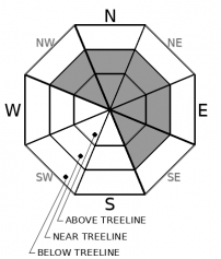
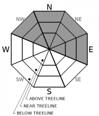
For 7000 ft. to 8000 ft.
Sunday Sunday Night Monday
Weather: Rain changing to snow in the afternoon. Snow through the night Mostly cloudy. Chance of snow.
Temperatures: 36 to 41 deg. F. 17 to 22 deg. F. 25 to 30 deg. F.
Mid Slope Winds: Southwest 20 to 30 mph increasing to 25 to 40 mph in the afternoon. Gusts up to 60 mph. Southwest 30 to 40 mph with gusts to 60 mph decreasing to 20 to 30 mph with gusts to 50 mph after midnight. West 10 to 15 mph with gusts to 35 mph in the morning becoming light.
Expected snowfall: 4 to 6'' 6 to 12" Up to 1"
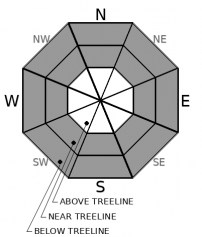
For 8000 ft. to 9000 ft.
Sunday Sunday Night Monday
Weather: Snow Snow through the night. Mostly cloudy, chance of snow.
Temperatures: 31 to 36 deg. F. 15 to 20 deg. F. 20 to 26 deg. F.
Ridge Top Winds: Southwest 35 to 55 mph with gusts to 90 mph. Southwest 35 to 55 mph with gusts to 95 mph decreasing to 30 to 45 mph with gusts to 70 mph after midnight. Northwest 15 to 30 mph with gusts to 60 mph.
Expected snowfall: 6 to 10" 8 to 14" Up to 1"
Disclaimer

This avalanche forecast is provided through a partnership between the Tahoe National Forest and the Sierra Avalanche Center. This forecast covers the Central Sierra Nevada Mountains between Yuba Pass on the north and Ebbetts Pass on the south. Click here for a map of the forecast area. This forecast applies only to backcountry areas outside established ski area boundaries. This forecast describes general avalanche conditions and local variations always occur. This forecast expires 24 hours after the posted time unless otherwise noted. The information in this forecast is provided by the USDA Forest Service who is solely responsible for its content.

For a recorded version of the avalanche forecast call (530) 587-3558 x258