THIS AVALANCHE FORECAST EXPIRED ON January 23, 2019 @ 6:59 am
Avalanche Forecast published on January 22, 2019 @ 6:59 am
Issued by Andy Anderson - Tahoe National Forest - Sierra Avalanche Center

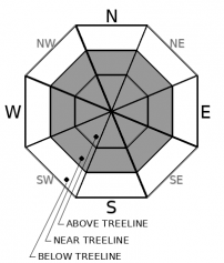
MODERATE avalanche danger exists at all elevations due to new and old wind slabs and a possible lingering deep slab problem. Human triggered avalanches remain possible today. 

2. Moderate

?

Above Treeline
Heightened avalanche conditions on specific terrain features. Evaluate snow and terrain carefully; identify features of concern.

2. Moderate

?

Near Treeline
Heightened avalanche conditions on specific terrain features. Evaluate snow and terrain carefully; identify features of concern.

2. Moderate

?

Below Treeline
Heightened avalanche conditions on specific terrain features. Evaluate snow and terrain carefully; identify features of concern.
    Heightened avalanche conditions on specific terrain features. Evaluate snow and terrain carefully; identify features of concern.
Avalanche Problem 1: Wind Slab
  • Type ?
  • Aspect/Elevation ?
  • Likelihood ?
    Certain
    Very Likely
    Likely
    Possible
    Unlikely
  • Size ?
    Historic
    Very Large
    Large
    Small

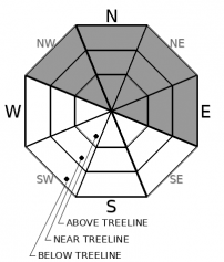
Human triggered wind slab avalanches could be possible on any wind exposed slopes on any aspect today. Strong NE winds over the last 24 hours combined with snow available for transport may have allowed new wind slabs to form on typically windward W-SW-S aspects. Older wind slabs formed by SW winds during the storm could also still exist in some places on N-NE-E aspects. Both wind directions could have cross-loaded the NW and SE aspects. Wind slab avalanches could involve enough snow to bury a person or injure a person or could be even larger in the most heavily wind-loaded areas.  

Identify terrain where wind slabs may exist using clues like cornices above a slope, blowing snow, hollow sounding firm snow, and other wind created features. Not only will these areas be more likely to hold wind slabs but they may also hold less fun snow conditions. Choosing slopes sheltered from the wind could provide better snow conditions and fewer avalanche concerns. 

Avalanche Problem 2: Deep Slab
  • Type ?
  • Aspect/Elevation ?
  • Likelihood ?
    Certain
    Very Likely
    Likely
    Possible
    Unlikely
  • Size ?
    Historic
    Very Large
    Large
    Small

While deep slab avalanches have become difficult to trigger in most places, they may remain possible on some NW-N-NE (and maybe E) facing slopes. Large triggers like falling cornices, other avalanches, or multiple people on the same slope may still be able to trigger a deep slab in some terrain. Complex terrain with steep cliffy areas, overlapping avalanche paths, and lots of trigger points represents the most suspect terrain. Significant uncertainty exists concerning whether or not deep slab avalanches could occur. 

Unfortunately, these are hard to predict and careful snowpack evaluation may miss the problem. Due to the uncertainty surrounding this problem and its potential consequences, creating travel plans with larger than normal safety buffers represents a good choice. Identifying and avoiding terrain where deep slabs may exist remains one of the only ways to effectively deal with deep slab problems even on a MODERATE day.

recent observations

* A skier triggered avalanche occurred in the Sand Chutes on Mt. Rose. It ran several hundred feet down the chute. This slide was reported by a party who saw it from a distance and no other details were available. 

* Observations from the Powderhouse Peak, Hidden Peak, Rubicon Peak, and Tamarack Peak all found that ski kicks on small wind-loaded test slopes near ridges would produce small shooting cracks in the wind slabs. A party on Jakes Peak also reported some "wind slab activity" but did not give any other details. NE winds were transporting snow for much of the day on Tamarack Peak.

* Snowpit data from Hidden Peak targetting the deeply buried surface hoar and old facet layers indicated that these old persistent weak layers may have gained some strength in that area.

* The Kirkwood Ski Patrol was able to remotely trigger a deep slab avalanche on a difficult-to-access, rarely-skied slope with a 2lb explosive shot placed 100 ft away from the slope. This slide broke on the old facet layer that is now more than 4 ft. deep. While this did release in a ski area with explosives, it may be representative of what could happen in the backcountry with larger triggers

Weather and CURRENT CONDITIONS
weather summary

Winds shifted to the NE yesterday and should remain strong along the ridgetops through today as a high pressure ridge builds over the area. These winds should begin to decrease tonight and tomorrow. The high pressure should also bring clear skies and warming temperatures to the region over the next few days.

CONDITIONS ALONG THE SIERRA CREST BETWEEN 8200 FT. AND 9200 FT. IN THE LAST 24 HOURS
6am temperature: 10 to 16 deg. F.
Max. temperature: 18 to 25 deg. F.
Average ridgetop wind direction: NE
Average ridgetop wind speed: 25 to 35 mph
Maximum ridgetop wind gust: 63 mph
New snowfall: 0 inches
Total snow depth: 70 to 97 inches
Two-Day Mountain Weather Forecast Produced in partnership with the Reno NWS
For 7000 ft. to 8000 ft.
Tuesday Tuesday Night Wednesday
Weather: Sunny. Snow levels below 7000 feet. Chance of precipitation is 0%. Clear then becoming partly cloudy. Snow levels below 7000 feet. Chance of precipitation is 0%. Sunny. Snow levels below 7000 feet increasing to 7500 feet in the afternoon. Chance of precipitation is 0%.
Temperatures: 32 to 37 deg. F. 16 to 22 deg. F. 38 to 43 deg. F.
Mid Slope Winds: Gusts up to 35 mph decreasing to 25 mph in the afternoon. Light winds. Light winds.
Expected snowfall: No accumulation. | SWE = none. No accumulation. | SWE = none. No accumulation. | SWE = none.
For 8000 ft. to 9000 ft.
Tuesday Tuesday Night Wednesday
Weather: Sunny. Snow levels below 7000 feet. Chance of precipitation is 0%. Clear then becoming partly cloudy. Snow levels below 7000 feet. Chance of precipitation is 0%. Sunny. Snow levels below 7000 feet increasing to 7500 feet in the afternoon. Chance of precipitation is 0%.
Temperatures: 31 to 36 deg. F. 18 to 23 deg. F. 37 to 42 deg. F.
Ridge Top Winds: Northeast 15 to 30 mph. Gusts up to 70 mph decreasing to 50 mph in the afternoon. Northeast 15 to 25 mph with gusts to 45 mph. Northwest 15 to 25 mph with gusts to 45 mph.
Expected snowfall: No accumulation. | SWE = none. No accumulation. | SWE = none. No accumulation. | SWE = none.
Disclaimer

This avalanche forecast is provided through a partnership between the Tahoe National Forest and the Sierra Avalanche Center. This forecast covers the Central Sierra Nevada Mountains between Yuba Pass on the north and Ebbetts Pass on the south. Click here for a map of the forecast area. This forecast applies only to backcountry areas outside established ski area boundaries. This forecast describes general avalanche conditions and local variations always occur. This forecast expires 24 hours after the posted time unless otherwise noted. The information in this forecast is provided by the USDA Forest Service who is solely responsible for its content.

For a recorded version of the avalanche forecast call (530) 587-3558 x258