THIS AVALANCHE FORECAST EXPIRED ON January 24, 2019 @ 6:59 am
Avalanche Forecast published on January 23, 2019 @ 6:59 am
Issued by Andy Anderson - Tahoe National Forest - Sierra Avalanche Center

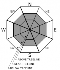
MODERATE avalanche danger exists in near and above treeline terrain with LOW danger in below treeline areas. Lingering wind slabs and unlikely but not impossible deep slabs represent today's avalanche problems. Human triggered avalanches may still remain possible in some areas.

2. Moderate

?

Above Treeline
Heightened avalanche conditions on specific terrain features. Evaluate snow and terrain carefully; identify features of concern.

2. Moderate

?

Near Treeline
Heightened avalanche conditions on specific terrain features. Evaluate snow and terrain carefully; identify features of concern.

1. Low

?

Below Treeline
Generally safe avalanche conditions. Watch for unstable snow on isolated terrain features.
    Heightened avalanche conditions on specific terrain features. Evaluate snow and terrain carefully; identify features of concern.
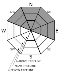
Avalanche Problem 1: Wind Slab
  • Type ?
  • Aspect/Elevation ?
  • Likelihood ?
    Certain
    Very Likely
    Likely
    Possible
    Unlikely
  • Size ?
    Historic
    Very Large
    Large
    Small

Strong SW winds during the storm and strong NE winds after the storm have left a mix of firm wind slabs, soft wind slabs, and scoured surfaces on most wind-exposed aspects. In areas where wind slabs exist, human-triggered wind slabs could still be possible. The newer wind slabs formed by the NE winds will remain more sensitive, but they should also be smaller and involve less snow. The older wind slabs formed by the SW winds could be larger but should be more difficult to trigger

Cornices above a slope, blowing snow, hollow sounding firm snow, and other wind created features can help identify where wind slabs and wind scoured/affected surfaces may exist. Choosing slopes sheltered from the wind could provide better snow conditions and fewer avalanche concerns. 

Avalanche Problem 2: Deep Slab
  • Type ?
  • Aspect/Elevation ?
  • Likelihood ?
    Certain
    Very Likely
    Likely
    Possible
    Unlikely
  • Size ?
    Historic
    Very Large
    Large
    Small

Strength gains in the persistent weak layers 4+ ft below the surface and the strong snow above those layers has made triggering a deep slab avalanche unlikely. Still, this problem may not be impossible in an isolated area where conditions are just right or with a large enough trigger (large cornice failures, multiple people on a slope, etc). Complex terrain with steep cliffy areas, overlapping avalanche paths, unsupported slopes, and lots of trigger points could represent some of the isolated areas where a surprise might still happen.

Some uncertainty still surrounds this problem. Pay close attention to areas where these old layers may exist especially in complex terrain when there is a potential for a large trigger to impact the slope. Good group management techniques like traveling one at a time from safe zone to safe zone and plans that provide buffer zones around suspect terrain could help create appropriate safety margins.

recent observations

* Observations from Trimmer Peak and Relay Peak found some signs of instabilities around small wind slabs on exposed upper elevations slopes. On Relay Peak cornices remained fragile but refrigerator sized cornice blocks dropped onto a wind-loaded slope did not trigger larger wind slabs

* Wind-scoured surfaces existed on ridgelines and on the upper portions of NE wind exposed slopes on Red Lake/Stevens Peak, Trimmer Peak, Angora Peak, Relay Peak, and on Silver Peak. In some areas, the wind scouring had brought the rain crust to the surface. Observers also noted blowing snow in some upper elevation areas near Trimmer Peak and on the Sierra Crest north of Silver Peak. 

* Below the ridges on Trimmer Peak, Red Lake/Stevens Peak, Angora Peak, Silver Peak, and Relay Peak wind effects decreased dramatically and soft unconsolidated snow existed on northerly aspects with some slightly sun affected snow on southerly aspects

* Snowpit data from Silver Peak targetting the deeply buried surface hoar and old facet layers yielded similar results to data from Hidden Peak on Monday and indicated that these old persistent weak layers continue to gain strength.

Weather and CURRENT CONDITIONS
weather summary

The strong NE winds started to decrease and shift towards the NW over the last 24 hours. The high-pressure ridge has also brought warmer air into the area with upper elevation temperatures above freezing in many places this morning. Cold air pooled in the valleys has set up inversion conditions. The forecast calls for warmer sunny weather to prevail over the next few days. 

CONDITIONS ALONG THE SIERRA CREST BETWEEN 8200 FT. AND 9200 FT. IN THE LAST 24 HOURS
6am temperature: 29 to 39 deg. F.
Max. temperature: 30 to 39 deg. F.
Average ridgetop wind direction: NE shifting to NW around 3 am.
Average ridgetop wind speed: 20 to 30 mph
Maximum ridgetop wind gust: 72 mph
New snowfall: 0 inches
Total snow depth: 69 to 92 inches
Two-Day Mountain Weather Forecast Produced in partnership with the Reno NWS
For 7000 ft. to 8000 ft.
Wednesday Wednesday Night Thursday
Weather: Sunny. Snow levels below 7000 feet increasing to 7500 feet in the afternoon. Chance of precipitation is 0%. Partly cloudy then becoming clear. Snow levels 7500 feet. Chance of precipitation is 5%. Sunny. Snow levels below 7000 feet. Chance of precipitation is 5%.
Temperatures: 40 to 45 deg. F. 20 to 25 deg. F. 37 to 42 deg. F.
Mid Slope Winds: Light winds. Light winds. Light winds.
Expected snowfall: No accumulation. | SWE = none. No accumulation. | SWE = none. No accumulation. | SWE = none.
For 8000 ft. to 9000 ft.
Wednesday Wednesday Night Thursday
Weather: Sunny. Snow levels below 7000 feet increasing to 7500 feet in the afternoon. Chance of precipitation is 0%. Partly cloudy then becoming clear. Snow levels 7500 feet. Chance of precipitation is 5%. Sunny. Snow levels below 7000 feet. Chance of precipitation is 5%.
Temperatures: 37 to 42 deg. F. 17 to 22 deg. F. 38 to 43 deg. F.
Ridge Top Winds: Northwest 15 to 25 mph with gusts to 40 mph. North 15 to 30 mph with gusts to 40 mph shifting to the northeast 15 to 20 mph with gusts to 30 mph after midnight. Northeast 10 to 15 mph.
Expected snowfall: No accumulation. | SWE = none. No accumulation. | SWE = none. No accumulation. | SWE = none.
Disclaimer

This avalanche forecast is provided through a partnership between the Tahoe National Forest and the Sierra Avalanche Center. This forecast covers the Central Sierra Nevada Mountains between Yuba Pass on the north and Ebbetts Pass on the south. Click here for a map of the forecast area. This forecast applies only to backcountry areas outside established ski area boundaries. This forecast describes general avalanche conditions and local variations always occur. This forecast expires 24 hours after the posted time unless otherwise noted. The information in this forecast is provided by the USDA Forest Service who is solely responsible for its content.

For a recorded version of the avalanche forecast call (530) 587-3558 x258