THIS AVALANCHE FORECAST EXPIRED ON January 27, 2019 @ 6:46 am
Avalanche Forecast published on January 26, 2019 @ 6:46 am
Issued by Brandon Schwartz - Tahoe National Forest

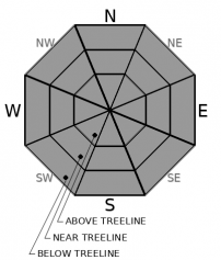
LOW avalanche danger continues for all elevations. Isolated areas of unstable snow may exist. Consider how terrain exposure may increase the consequences of a small unexpected avalanche.

1. Low

?

Above Treeline
Generally safe avalanche conditions. Watch for unstable snow on isolated terrain features.

1. Low

?

Near Treeline
Generally safe avalanche conditions. Watch for unstable snow on isolated terrain features.

1. Low

?

Below Treeline
Generally safe avalanche conditions. Watch for unstable snow on isolated terrain features.
    Generally safe avalanche conditions. Watch for unstable snow on isolated terrain features.
Avalanche Problem 1: Normal Caution
  • Type ?
  • Aspect/Elevation ?
  • Likelihood ?
    Certain
    Very Likely
    Likely
    Possible
    Unlikely
  • Size ?
    Historic
    Very Large
    Large
    Small

Ridgetop winds out of the NE increased to strong in speed overnight. Wind speeds were similar to a previous NE wind event that occurred on January 22nd. Due to the previous wind event, limited snow was available for wind transport last night. Any new wind slab formation is expected to be small and isolated. Continued warming will allow for minor amounts of roller balls/loose wet instability in sun exposed areas at all elevations. Avalanches large enough to bury a person are unlikely today.

Identify areas of wet snow surface conditions or where newly formed wind slab exists. If any avalanche activity occurs today, it will most likely occur in one of these locations. Small avalanches that would often be inconsequential may have significant consequences if occurring above cliffs, terrain traps, or in rocky chutes. Accidents in the current conditions are often traced back to terrain exposure, reliance on marginal islands of safety, and/or poor communication.

recent observations

* Snow surface conditions are becoming affected by warming in many areas. The snow surface on shaded, wind protected N aspects remains unconsolidated and has escaped melt at the mid and upper elevations.

* Significant wind erosion of the snow surface has occurred in near treeline and above treeline areas on all aspects. Exposed rain crust and firm ice exist in some areas and present a travel hazard.

* Recent observations from around the forecast area indicate that the old weak layers buried deep in the snowpack continue to gain strength.

Weather and CURRENT CONDITIONS
weather summary

High pressure continues to build over the forecast area. Air temperature inversion conditions will allow for a continued warming trend over the mid slope and upper elevations. Ridgetop winds out of the NE increased to strong in speed yesterday evening. Winds are forecast to decrease through the day today. A shift to W winds tomorrow will allow of further warming at all elevations. Confidence is increasing in additional storm systems impacting the forecast area later this week.

CONDITIONS ALONG THE SIERRA CREST BETWEEN 8200 FT. AND 9200 FT. IN THE LAST 24 HOURS
6am temperature: 28 to 34 deg. F.
Max. temperature: 38 to 42 deg. F.
Average ridgetop wind direction: NE
Average ridgetop wind speed: 48 mph
Maximum ridgetop wind gust: 74 mph
New snowfall: 0 inches
Total snow depth: 65 to 87 inches
Two-Day Mountain Weather Forecast Produced in partnership with the Reno NWS
For 7000 ft. to 8000 ft.
Saturday Saturday Night Sunday
Weather: Sunny then becoming partly cloudy. Snow levels below 7000 feet increasing to 7000 feet in the afternoon. Chance of precipitation is 0%. Mostly cloudy. Snow levels 8000 feet. Chance of precipitation is 0%. Mostly cloudy then becoming partly cloudy. Snow levels 8000 feet. Chance of precipitation is 0%.
Temperatures: 43 to 48. deg. F. 20 to 30. deg. F. 51 to 56. deg. F.
Mid Slope Winds: Light winds. Light winds. Light winds.
Expected snowfall: No accumulation. | SWE = none. No accumulation. | SWE = none. No accumulation. | SWE = none.
For 8000 ft. to 9000 ft.
Saturday Saturday Night Sunday
Weather: Sunny then becoming partly cloudy. Snow levels below 7000 feet increasing to 7000 feet in the afternoon. Chance of precipitation is 0%. Mostly cloudy. Snow levels 8000 feet. Chance of precipitation is 0%. Mostly cloudy then becoming partly cloudy. Snow levels 8000 feet. Chance of precipitation is 0%.
Temperatures: 40 to 48. deg. F. 29 to 35. deg. F. 48 to 54. deg. F.
Ridge Top Winds: East 15 to 25 mph. Gusts up to 45 mph decreasing to 35 mph in the afternoon. Light winds. West 10 to 15 mph with gusts to 30 mph.
Expected snowfall: No accumulation. | SWE = none. No accumulation. | SWE = none. No accumulation. | SWE = none.
Disclaimer

This avalanche forecast is provided through a partnership between the Tahoe National Forest and the Sierra Avalanche Center. This forecast covers the Central Sierra Nevada Mountains between Yuba Pass on the north and Ebbetts Pass on the south. Click here for a map of the forecast area. This forecast applies only to backcountry areas outside established ski area boundaries. This forecast describes general avalanche conditions and local variations always occur. This forecast expires 24 hours after the posted time unless otherwise noted. The information in this forecast is provided by the USDA Forest Service who is solely responsible for its content.

For a recorded version of the avalanche forecast call (530) 587-3558 x258