THIS AVALANCHE FORECAST EXPIRED ON January 30, 2019 @ 6:59 am
Avalanche Forecast published on January 29, 2019 @ 6:59 am
Issued by Andy Anderson - Tahoe National Forest - Sierra Avalanche Center

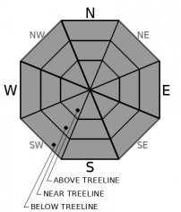
The avalanche danger remains LOW for all elevations. Continue to use normal caution while traveling in the backcountry.

1. Low

?

Above Treeline
Generally safe avalanche conditions. Watch for unstable snow on isolated terrain features.

1. Low

?

Near Treeline
Generally safe avalanche conditions. Watch for unstable snow on isolated terrain features.

1. Low

?

Below Treeline
Generally safe avalanche conditions. Watch for unstable snow on isolated terrain features.
    Generally safe avalanche conditions. Watch for unstable snow on isolated terrain features.
Avalanche Problem 1: Normal Caution
  • Type ?
  • Aspect/Elevation ?
  • Likelihood ?
    Certain
    Very Likely
    Likely
    Possible
    Unlikely
  • Size ?
    Historic
    Very Large
    Large
    Small

If any rain does fall today, it could help soften some snow surfaces. Otherwise, cloud cover and slightly cooler temperatures should keep most snow surfaces frozen. In the areas that do receive rain, limited precipitation amounts should not be enough to create more than small wet snow instabilities. If light snow falls at upper elevations, some "dust on crust" conditions may result. Variable firm snow surfaces still exist in many places including frozen sun crusts on solar aspects, icy rain crusts on wind-scoured slopes, and uneven firm wind textures on exposed slopes. While avalanche activity remains unlikely, the firm surfaces could make travel challenging and allow for other hazards including long sliding falls.

Matching backcountry travel plans to the skills of your group can help find enjoyable and safe recreation opportunities. Maintain awareness of the conditions and terrain to help find the best conditions for your crew. Stop and talk to each other to make sure everyone is on the same page and comfortable with the current conditions and terrain selections. 

recent observations

* Cloud cover kept most snow surfaces frozen yesterday. On the upper elevations of Stevens Peak and Castle Peak, observations revealed firm surface conditions ranging from frozen sun crusts on sun-exposed slopes to old icy rain crusts and uneven wind-textured surfaces on wind-scoured aspects. Some small patches of soft snow did exist on sheltered and shaded N aspects of Stevens Peak.

* Warm, wet, and sticky snow existed in lower elevation areas on Castle Peak and Stevens Peak yesterday. Ski cuts on steep rollovers on Stevens Peak did cause some small rollerballs and pinwheels. 

Weather and CURRENT CONDITIONS
weather summary

The forecast calls for the first in a series of disturbances to move through the area today and this evening. Temperatures should remain warm with highs in the 40's above 7000 ft. This small system may bring some light precipitation to the area in the form of rain below ~7500 ft and light snow above that. If any precipitation does fall accumulations should stay below .1 inches of water or less than an inch of snow. Some light SW winds may also occur. While this system remains unimpressive and small, it does herald a change in the weather with stronger storms forecasted later this week. Check in with the Reno NWS for more details.

CONDITIONS ALONG THE SIERRA CREST BETWEEN 8200 FT. AND 9200 FT. IN THE LAST 24 HOURS
6am temperature: 35 to 42 deg. F.
Max. temperature: 44 to 48 deg. F.
Average ridgetop wind direction: NE to SW
Average ridgetop wind speed: 5 to 15 mph
Maximum ridgetop wind gust: 34 mph
New snowfall: 0 inches
Total snow depth: 62 to 82 inches
Two-Day Mountain Weather Forecast Produced in partnership with the Reno NWS
For 7000 ft. to 8000 ft.
Tuesday Tuesday Night Wednesday
Weather: Mostly cloudy. Chance of rain and snow. Snow levels 7500 feet. Chance of precipitation is 25%. Mostly cloudy. Slight chance of rain and snow in the evening. Snow levels 7500 feet. Chance of precipitation is 15%. Mostly cloudy. Snow levels below 7000 feet increasing to 7500 feet in the afternoon. Chance of precipitation is 10%.
Temperatures: 40 to 45 deg. F. 23 to 29 deg. F. 41 to 46 deg. F.
Mid Slope Winds: Light winds. Light winds. Light winds.
Expected snowfall: 30% probability up to 1 inch. 70% probability no accumulation. | SWE = less than 0.10 inch. 30% probability up to 1 inch. 70% probability no accumulation. | SWE = trace amounts. No accumulation. | SWE = none.
For 8000 ft. to 9000 ft.
Tuesday Tuesday Night Wednesday
Weather: Mostly cloudy. Chance of snow. Snow levels 7500 feet. Chance of precipitation is 25%. Mostly cloudy. Slight chance of snow in the evening. Snow levels 7500 feet. Chance of precipitation is 15%. Mostly cloudy. Snow levels below 7000 feet increasing to 7500 feet in the afternoon. Chance of precipitation is 10%.
Temperatures: 37 to 43 deg. F. 23 to 28 deg. F. 37 to 43 deg. F.
Ridge Top Winds: Southwest 15 to 20 mph with gusts to 35 mph. Light winds. Light winds.
Expected snowfall: 30% probability up to 1 inch. 70% probability no accumulation. | SWE = less than 0.10 inch. 30% probability up to 1 inch. 70% probability no accumulation. | SWE = trace amounts. No accumulation. | SWE = none.
Disclaimer

This avalanche forecast is provided through a partnership between the Tahoe National Forest and the Sierra Avalanche Center. This forecast covers the Central Sierra Nevada Mountains between Yuba Pass on the north and Ebbetts Pass on the south. Click here for a map of the forecast area. This forecast applies only to backcountry areas outside established ski area boundaries. This forecast describes general avalanche conditions and local variations always occur. This forecast expires 24 hours after the posted time unless otherwise noted. The information in this forecast is provided by the USDA Forest Service who is solely responsible for its content.

For a recorded version of the avalanche forecast call (530) 587-3558 x258