THIS AVALANCHE FORECAST EXPIRED ON January 9, 2019 @ 6:55 am
Avalanche Forecast published on January 8, 2019 @ 6:55 am
Issued by Steve Reynaud - Tahoe National Forest

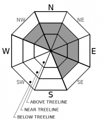
MODERATE avalanche danger will exist at all elevations throughout the forecast region due to wind slab and persistent slab avalanche problems.  Large destructive human triggered avalanches could be possible today. 

2. Moderate

?

Above Treeline
Heightened avalanche conditions on specific terrain features. Evaluate snow and terrain carefully; identify features of concern.

2. Moderate

?

Near Treeline
Heightened avalanche conditions on specific terrain features. Evaluate snow and terrain carefully; identify features of concern.

2. Moderate

?

Below Treeline
Heightened avalanche conditions on specific terrain features. Evaluate snow and terrain carefully; identify features of concern.
    Heightened avalanche conditions on specific terrain features. Evaluate snow and terrain carefully; identify features of concern.
Avalanche Problem 1: Wind Slab
  • Type ?
  • Aspect/Elevation ?
  • Likelihood ?
    Certain
    Very Likely
    Likely
    Possible
    Unlikely
  • Size ?
    Historic
    Very Large
    Large
    Small

Large wind slabs that formed during our last storm with up to 4 feet of snow and over 100mph winds exist on NW-N-NE-E-SE aspects in near and above treeline terrain.  These wind slabs will take time to adjust to the new load and gain strength.  Some of these wind slabs sit on top of old weak faceted snow layers that could allow for remote triggering, wide propagation, and large avalanches.  Strong to gale force winds will return today ahead of our next storm.  Another round of wind slab development will become possible as snow transport begins.


Avalanche Problem 2: Persistent Slab
  • Type ?
  • Aspect/Elevation ?
  • Likelihood ?
    Certain
    Very Likely
    Likely
    Possible
    Unlikely
  • Size ?
    Historic
    Very Large
    Large
    Small

Old weak faceted snow that was buried during our last storm cycle is showing signs of weakness in many areas of the forecast region.  These old near surface facets exists below 1.5 to 4' of recent storm snow.  Easy snowpack test failures along with widespread whumpfing and collapsing of the snowpack on this facet layer occurred yesterday in multiple areas.  Uncertainty exists as to how long this weak layer will last and if any avalanche activity has occurred.  This layer has been found in the 7000-9000' elevation range on NW-N-NE-E aspects.   

Large destructive avalanches are possible today.  Remote triggering and wide propagation could occur.  Until more information is learned, terrain management and conservative decision making are essential.  Travel on slopes well under 30 degrees with no overhead hazards.  Whumpfing or collapsing of the snowpack would indicate that this layer is still weak and potentially reactive. 

recent observations

*  Observations from Hidden Peak (West Shore area) showed widespread whumpfing and collapsing of the snowpack failing on the weak old faceted snow that is below the recent storm snow.  Consistent easy snowpack test results observed.  A large density change in the upper snowpack was observed up to high point of 8700'. 

*  Observations from Powderhouse Peak and Trimmer Peak ( Luther Pass area) and Andesite Peak (Donner Summit area) all showed similar conditions with whumpfing and collapsing of the snowpack on the old near surface facets.  Snowpack test results showed failure on the faceted layer.  Weaknesses were also found under the large density change within the storm snow.

*  At Incline Lake Peak (Mt. Rose area) some storm snow instabilities existed.  Weakness at the old snow surface was not as pronounced as in other areas.

*  Please let us know what you see out there!

Weather and CURRENT CONDITIONS
weather summary

Quiet weather for most of today before another storm enters our area tonight and into Wednesday.  Clouds and wind will be on the increase today with snow occurring late tonight and into Wednesday.  A winter weather advisory is in effect from 1am to 9pm Wednesday.  This storm has the potential to produce 6 to 12'' of additional snow along the Sierra Crest above 7000'.  Snow levels should start out around 7000-7500' tonight before dropping to lake level by Wednesday morning.  Uncertainty exists about the weather pattern into the weekend and if snow remains possible.

CONDITIONS ALONG THE SIERRA CREST BETWEEN 8200 FT. AND 9200 FT. IN THE LAST 24 HOURS
6am temperature: 33 to 40 deg. F.
Max. temperature: 40 deg. F.
Average ridgetop wind direction: SW to S
Average ridgetop wind speed: 15 to 25 mph
Maximum ridgetop wind gust: 96 mph
New snowfall: 0 to Trace inches
Total snow depth: 48 to 53 inches
Two-Day Mountain Weather Forecast Produced in partnership with the Reno NWS
For 7000 ft. to 8000 ft.
Tuesday Tuesday Night Wednesday
Weather: Cloudy. Slight chance of showers. Snow levels 7500 feet. Chance of precipitation is 15%. Cloudy. Slight chance of rain and snow in the evening, then snow likely after midnight. Snow levels 7000 feet. Chance of precipitation is 55%. Cloudy. Snow in the morning, then chance of snow in the afternoon. Snow levels below 7000 feet. Chance of precipitation is 75%.
Temperatures: 38 to 43. deg. F. 27 to 32. deg. F. 37 to 42. deg. F.
Mid Slope Winds: South 15 to 20 mph. Gusts up to 30 mph increasing to 40 mph in the afternoon. South 15 to 25 mph with gusts to 50 mph. South 15 to 30 mph with gusts to 45 mph.
Expected snowfall: No accumulation. | SWE = trace amounts. 80% probability up to 2 to 4 inches. 20% probability of 3 to 6 inches. | SWE = up to 0.20 inch. 90% probability of 2 to 4 inches. 10% probability of 4 to 8 inches. | SWE = 0.25-0.50 inch.
For 8000 ft. to 9000 ft.
Tuesday Tuesday Night Wednesday
Weather: Mostly cloudy. Slight chance of snow showers in the afternoon. Snow levels 7500 feet. Chance of precipitation is 15%. Cloudy. Chance of snow. Snow levels 7000 feet. Chance of precipitation is 55%. Cloudy. Snow in the morning, then chance of snow in the afternoon. Snow levels below 7000 feet. Chance of precipitation is 75%.
Temperatures: 35 to 40. deg. F. 25 to 30. deg. F. 35 to 40. deg. F.
Ridge Top Winds: South 15 to 30 mph with gusts to 50 mph increasing to 30 to 40 mph with gusts to 70 mph in the afternoon. South 35 to 50 mph increasing to 45 to 55 mph after midnight. Gusts up to 95 mph. South 40 to 60 mph with gusts to 95 mph.
Expected snowfall: No accumulation. | SWE = trace amounts. 80% probability of 2 to 4 inches. 20% probability of 3 to 6 inches. | SWE = up to 0.20 inch. 90% probability of 4 to 8 inches. 10% probability of 6 to 12 inches. | SWE = 0.30-0.55 inch.
Disclaimer

This avalanche forecast is provided through a partnership between the Tahoe National Forest and the Sierra Avalanche Center. This forecast covers the Central Sierra Nevada Mountains between Yuba Pass on the north and Ebbetts Pass on the south. Click here for a map of the forecast area. This forecast applies only to backcountry areas outside established ski area boundaries. This forecast describes general avalanche conditions and local variations always occur. This forecast expires 24 hours after the posted time unless otherwise noted. The information in this forecast is provided by the USDA Forest Service who is solely responsible for its content.

For a recorded version of the avalanche forecast call (530) 587-3558 x258