THIS AVALANCHE FORECAST EXPIRED ON March 12, 2019 @ 6:48 am
Avalanche Forecast published on March 11, 2019 @ 6:48 am
Issued by Steve Reynaud - Tahoe National Forest

MODERATE avalanche danger will exist due to wind slab and loose wet avalanche problems at all elevations.  Human triggered avalanches remain possible today.

2. Moderate

?

Above Treeline
Heightened avalanche conditions on specific terrain features. Evaluate snow and terrain carefully; identify features of concern.

2. Moderate

?

Near Treeline
Heightened avalanche conditions on specific terrain features. Evaluate snow and terrain carefully; identify features of concern.

2. Moderate

?

Below Treeline
Heightened avalanche conditions on specific terrain features. Evaluate snow and terrain carefully; identify features of concern.
    Heightened avalanche conditions on specific terrain features. Evaluate snow and terrain carefully; identify features of concern.
Avalanche Problem 1: Wind Slab
  • Type ?
  • Aspect/Elevation ?
  • Likelihood ?
    Certain
    Very Likely
    Likely
    Possible
    Unlikely
  • Size ?
    Historic
    Very Large
    Large
    Small

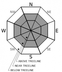
Lingering wind slabs continue to exist on NW-N-NE-E-SE aspects in near and above treeline terrain.  These wind slabs remain reactive to triggering with wind slab avalanches up to size D2 occurring recently.  Yesterday, winds shifted from the SW to the NE and have been moderate in speed.  Wind transport along with new wind slab development will continue on SE-S-SW-W-NW aspects in wind exposed near and above treeline terrain.  Rapid warming today may weaken existing wind slabs and cornices

Blowing snow, snow surface clues, and new cornice development should help to identify where new wind slabs are located.  Large cornices exist throughout the forecast region and represent potential overhead hazards.  Make a trip plan to avoid these specific areas.

Avalanche Problem 2: Loose Wet
  • Type ?
  • Aspect/Elevation ?
  • Likelihood ?
    Certain
    Very Likely
    Likely
    Possible
    Unlikely
  • Size ?
    Historic
    Very Large
    Large
    Small

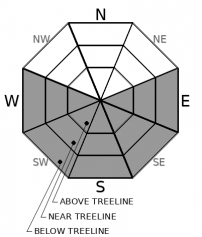
Gradual warming with the possibility of sunny skies today will allow loose wet instabilities to form on E-SE-S-SW-W aspects.  Depending on the amount of solar radiation occurring at your location, this rapid warming could start by mid to late morning.  Most instabilities should be in the form of roller balls and pinwheels and be relatively small in size.  Larger loose wet avalanches that involve all of the recent storm snow could occur in some areas that experience more warming.

Small roller balls, sticky snow, and deteriorating snow conditions will all indicate that the snow surface is warming and starting to loose strength.  Change aspects or avoid avalanche terrain that is experiencing rapid warming conditions.

recent observations

Wind slab avalanche activity yesterday reported from Granite Chief Peak (Squaw Valley area), Rifle Peak (Mt. Rose area), and Castle Ridge (Donner Summit area).  Wind slab avalanches up to size D2 reported.

*  Large cornices observed throughout the region.  Cornice collapses reported yesterday from Johnson Canyon (Donner Summit area) at 7400' on east aspects.

*  Southerly aspects have thin sun crusts, wet snow, and variable conditions.

Weather and CURRENT CONDITIONS
weather summary

A quiet weather day with the potential for some light snow showers and partly cloudy skies.  NE winds will be in the moderate range above 8000' with higher gusts possible in the most wind exposed areas.  A small weather disturbance will move into the area on Tuesday bringing light snow showers and increased winds.  Winds will shift back to the SW tomorrow and then move to the NW post storm.   High pressure begins to build in on Wednesday with light winds and gradual warming temperatures.  This high pressure may provide a long break in the storm activity with spring conditions forecasted. 

CONDITIONS ALONG THE SIERRA CREST BETWEEN 8200 FT. AND 9200 FT. IN THE LAST 24 HOURS
6am temperature: 17 to 21 deg. F.
Max. temperature: 32 deg. F.
Average ridgetop wind direction: NE
Average ridgetop wind speed: 20 to 35 mph
Maximum ridgetop wind gust: 57 mph
New snowfall: Trace to 2 inches
Total snow depth: 126 to 136 inches
Two-Day Mountain Weather Forecast Produced in partnership with the Reno NWS
For 7000 ft. to 8000 ft.
Monday Monday Night Tuesday
Weather: Mostly cloudy then becoming partly cloudy. Snow levels below 7000 feet. Chance of precipitation is 5%. Clear. Snow levels below 7000 feet. Chance of precipitation is 0%. Partly cloudy then becoming mostly cloudy. Chance of snow in the afternoon. Snow levels below 7000 feet. Chance of precipitation is 50%.
Temperatures: 32 to 37. deg. F. 13 to 21. deg. F. 32 to 37. deg. F.
Mid Slope Winds: Northeast around 15 mph in the morning becoming light. Gusts up to 30 mph. Light winds. Light winds becoming southwest 15 to 20 mph with gusts to 45 mph in the afternoon.
Expected snowfall: No accumulation. | SWE = none. No accumulation. | SWE = none. 80% probability up to 1 inch. | SWE = less than 0.10 inch.
For 8000 ft. to 9000 ft.
Monday Monday Night Tuesday
Weather: Mostly cloudy then becoming partly cloudy. Snow levels below 7000 feet. Chance of precipitation is 5%. Clear. Snow levels below 7000 feet. Chance of precipitation is 0%. Partly cloudy then becoming mostly cloudy. Chance of snow in the afternoon. Snow levels below 7000 feet. Chance of precipitation is 50%.
Temperatures: 27 to 33. deg. F. 12 to 17. deg. F. 28 to 34. deg. F.
Ridge Top Winds: Northeast around 15 mph with gusts to 30 mph. Light winds becoming east around 15 mph after midnight. Southwest 15 to 25 mph with gusts to 40 mph increasing to 25 to 35 mph with gusts to 65 mph in the afternoon.
Expected snowfall: No accumulation. | SWE = none. No accumulation. | SWE = none. 80% probability up to 1 inch. | SWE = less than 0.10 inch.
Disclaimer

This avalanche forecast is provided through a partnership between the Tahoe National Forest and the Sierra Avalanche Center. This forecast covers the Central Sierra Nevada Mountains between Yuba Pass on the north and Ebbetts Pass on the south. Click here for a map of the forecast area. This forecast applies only to backcountry areas outside established ski area boundaries. This forecast describes general avalanche conditions and local variations always occur. This forecast expires 24 hours after the posted time unless otherwise noted. The information in this forecast is provided by the USDA Forest Service who is solely responsible for its content.

For a recorded version of the avalanche forecast call (530) 587-3558 x258